
Catherine Walsh
Nine sculptures made from eight blocks of marble comprise the Juno Fountain commissioned by Cosimo I de’ Medici (1519-1574) for the Sala Grande of the Palazzo Vecchio (Fig. 1). The sculptures represent Juno, Ceres, Arno, Parnassus, Florence, Temperance, two peacocks, and an arc around and within which the figures are situated. Its iconography has inspired varied nuanced interpretations, but generally this artwork is understood as an allegory of the generation of water that emphasized Cosimo’s patronage of new aqueducts for Florence. Quarrying for the project began in 1555; Bartolomeo Ammannati (1511-1592) started work on it in 1556, probably completing it by 1563; and most of its parts remained in the Palazzo Vecchio until 1579, when their movement around Florence and its environs commenced, persisting for almost four centuries.[1]
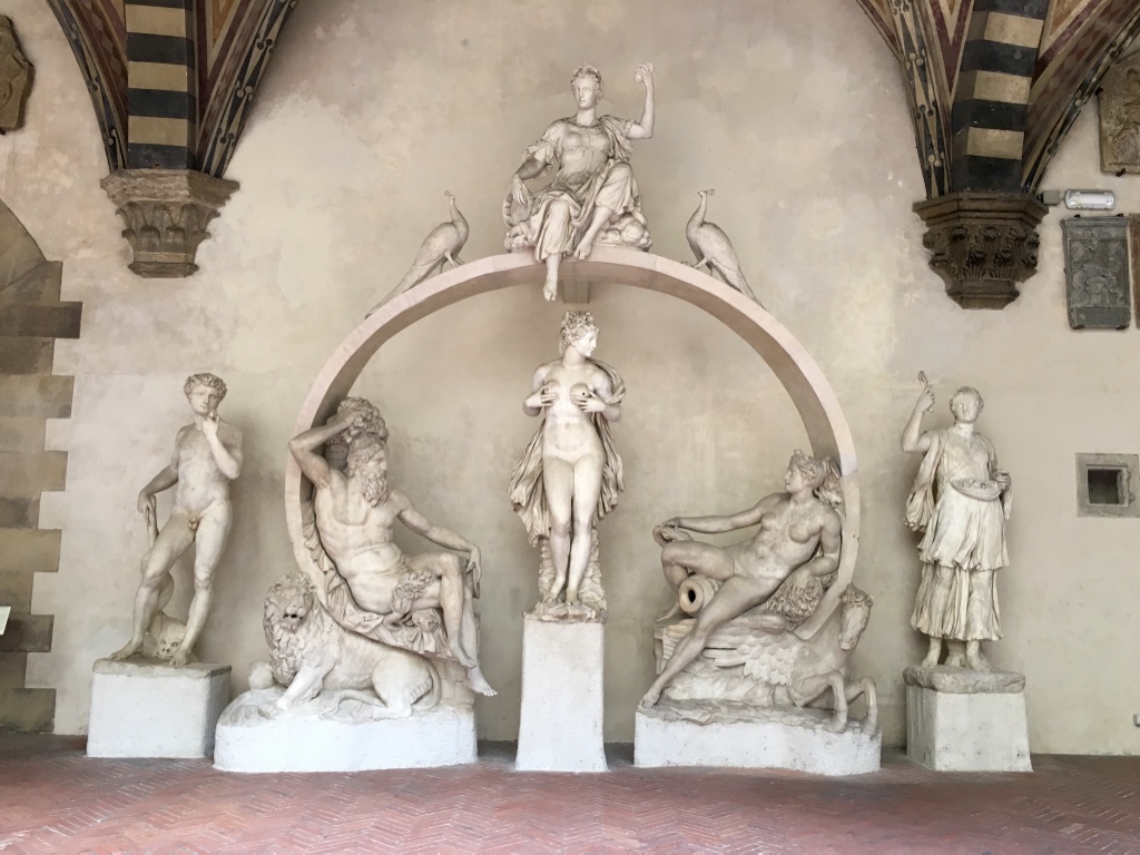
Fig. 1. Bartolomeo Ammannati, Juno Fountain, c. 1563. Marble, variable dimensions. From left: Temperance, Arno, Ceres, Parnassus, Florence; Above: Juno and peacocks. Museo Nazionale del Bargello, Florence. Photo by Catherine Walsh, 2017.
According to Detlef Heikamp, one of the artwork’s biographers, the itinerant sculptures, “after centuries of wandering,” could finally rest, “reunited,” at the Museo Nazionale del Bargello in 1973.[2] In 1977, a partial reconstruction was exhibited. Not until 2010 were all components reassembled and exhibited together.[3] Beginning with the earliest scholarship on the fountain, the changing locations of its sculptures have concerned researchers. However, most scholarship focuses on reconstruction of Ammannati’s original concept for the Sala Grande and interpretation of the iconography, while summarizing the acts of “wandering” that inspired careful inspection by scholars Friedrich Kriegbaum and Heikamp in the early and mid-twentieth century. The present study draws upon Kriegbaum’s and Heikamp’s work, but probes deeper into the movement of the fountain by using digital mapping methods to reexamine its unsettled sculptures.
Digital mapping facilitates the visual representation of relationships between artworks and places over time and the reconciliation of early modern descriptions of space with our current conceptions of geographical space. Multiple art historical mapping projects demonstrate the usefulness of digital tools for studying movement through space or its reshaping. For instance, Mapping Titian, Mapping Art Markets in Europe: 1300-1800, Artists in Paris, Mapping Gothic France, and The Nolli Map Website represent the potential of digital mapping to visualize and analyze provenance, trade of artworks, social lives of artists, and changes in the built environment and urban landscape. Like these projects, the present study emphasizes the ability of geographical data and visualizations to help us better understand artworks; this study distinguishes itself with a particular interest in the applicability of GIS tools for the tasks of analyzing dimensions and distances of spaces of/and sculptures, foregrounding uncertainty, and emphasizing the sculptures’ changing locations. Plotting spatial configurations with this technology allows for the reframing of longstanding art historical questions about the relationship between art and nature and between formal elements of artworks and their environments, while also highlighting blind spots and foci in reception histories. Still, the geographical visualizations generated for the present study do not easily resolve questions provoked by the Juno Fountain, nor do they intend to. The fountain sculptures’ spatial and temporal metadata reflect lingering uncertainty about various aspects of the sculptures’ afterlives. This uncertainty carries over to data curation issues representative of those encountered with other early modern, multi-part artworks that have become fragmented, such as altarpieces whose panels have been dispersed.[4] Focusing on the period from 1635 to 1789, this study demonstrates the challenges of and potential for using computational spatial analysis methods to visualize the dynamic afterlife of Ammannati’s Juno Fountain.
“Restlessness” and Fragmentation
Correspondence, payment records, literary descriptions, and visual depictions inform the spatial history of the fountain’s individual sculptures: when they moved, how long they remained in each location, how many sculptures were present, and how they were positioned. But inconsistencies between sources inspire many questions about the sculptures’ geographical statuses and their physical relationships to one another; lacunae in these sources make it impossible to fully understand the sculptures’ afterlives. Moreover, locations of some of the sculptures were unknown by the early twentieth century. These issues—irreconcilable data, gaps in knowledge, and absence of objects and records of them—present challenges for tracing the sculptures’ movements through space and time. The dismantling of the original sculptural composition and its traveling in a variety of configurations—sometimes multiple sculptures together, sometimes figures singly—further complicate matters. Understanding the spatial history of the fountain therefore requires tracking nine different itineraries.
Kriegbaum tackled this complex problem in his 1927 study, the first to trace the sculptures’ extended travels. Having recently found most of the components of this “lost fountain,” he characterized its life as one of itinerancy.[5] In this foundational scholarship, he described the fountain’s sculptures as “restless,” an apt term that I will deploy in this essay and explore in the accompanying visualizations.[6] The sculptures traveled from the Palazzo Vecchio to Pratolino (the villa and park developed by Francesco I de’ Medici (1541-1587)) less than two decades after Ammannati completed them, and returned to Florence by 1589. They continued to roam, “wander[ing]” into the garden of the Casino di San Marco in the 1630s and out of the garden in the 1730s.[7] Kriegbaum suggested that the sculptures, becoming untraceable in the mid-eighteenth century, then took on a temporary fugitive status. It was not until 1968 that all components, with the exception of the arc, were located.
Kriegbaum’s notion of the “restless” artwork reverberated in later studies. In his 1978 essay, Heikamp described its afterlife as one of “vagrant existence … [and] ever shifting locations.”[8] Building upon Kriegbaum’s work, Heikamp methodically examined the sculptures’ movements over four centuries. He included current information about the location of three sculptures (Juno and two peacocks) that remained lost to Kriegbaum.[9] Heikamp’s research on the fountain led to a new graphical reconstruction of it and, subsequently, the 1977 exhibition at the Bargello. His discussions of the fountain’s iconography and history of construction continue to be consequential for scholars; his published transcriptions of many relevant documents and literary descriptions of the fountain remain invaluable.[10]
Recent scholarship has revisited sixteenth-century accounts of the earliest locations of the sculptures. In his examination of the relationship of Florence and Temperance to the original fountain composition, Dimitrios Zikos addressed three alternatives for their placement, emphasizing gaps in the archival record and ambiguous descriptions in primary sources that reflected confusion about the sculptures’ (intended) destinations in the 1560s and 1570s as well as their iconographical meaning.[11] Zikos’ discussion brings into relief the complexity of interpreting these two figures, the tenuous nature of earlier reconstructions of the fountain that include them, and the significance of their (hypothetical) locations for these efforts.
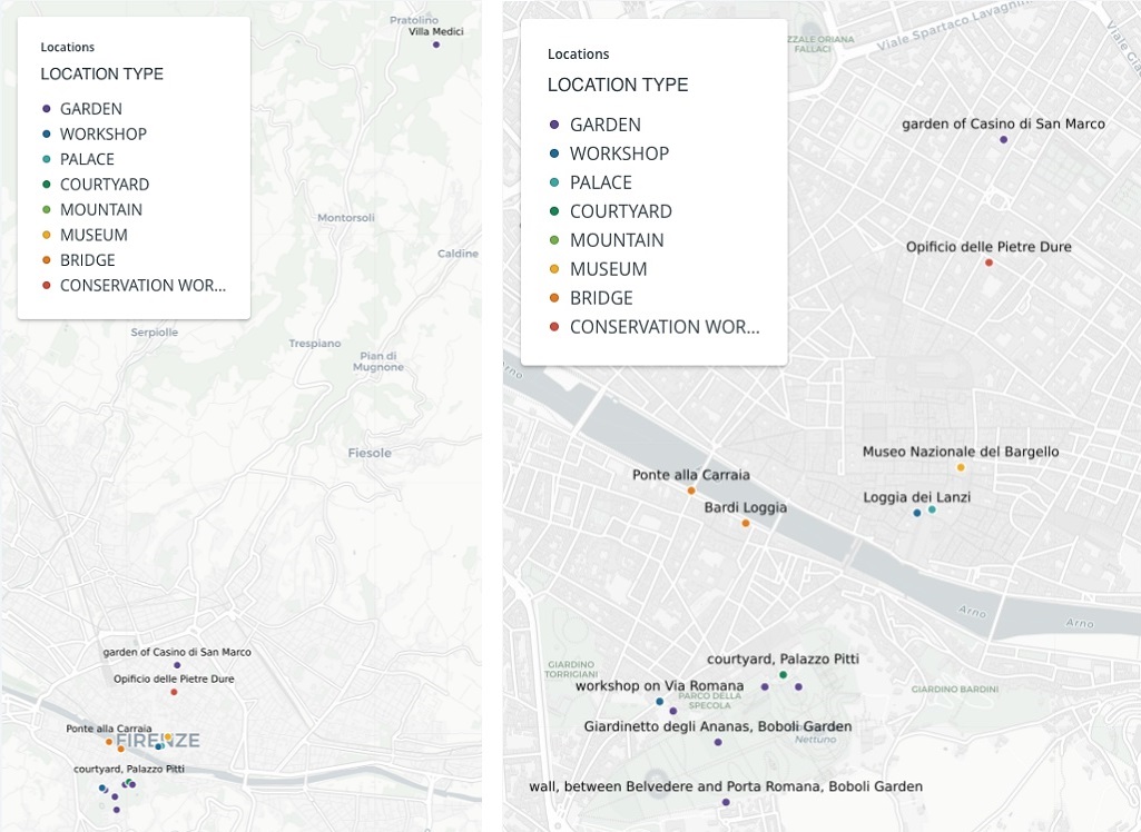
LEFT: Fig. 2. Locations of Juno Fountain sculptures, 1579-2017. Map created by Catherine Walsh using CARTO, 2018.
RIGHT: Fig. 3. Locations of Juno Fountain sculptures, zoomed to the Florence city center, 1579-2017. Map created by Catherine Walsh using CARTO, 2018.
It is unsurprising that such questions about the spatial history of the fountain persist. Not only do nine itineraries exist, but these journeys were multi-part, with individual sculptures occupying as few as six locations or as many as thirteen. Since 1579, the sculptures have inhabited at least eight different spaces (Figs. 2 and 3), sometimes moving around within a single site: the Palazzo Vecchio, Bardi Loggia, Pratolino, Palazzo Pitti courtyard terrace, Casino di San Marco garden, Boboli Garden, Pitti offices of the Soprintendenza, and Bargello.[12] Within the Pitti-Boboli complex, the sculptures were twice installed as a complete group, while moving multiple times to at least seven different places. In some instances the sculptures were displayed as stand-alone statues, and in others they were incorporated into niches or fountains with other objects.
Attributing the survival of the sculptures to their reuse, Heikamp invoked Kriegbaum’s characterization when he asserted that the 1574 deaths of Cosimo I de’ Medici, the patron of the fountain, and his advisor, Giorgio Vasari (1511-1574), precipitated the “wandering life of the statues.”[13] Cosimo’s successors, his sons Francesco and Ferdinando I de’ Medici (1549-1609), immediately repurposed the fountain in late sixteenth-century gardens. For example, Francesco had the sculptures moved to Pratolino, where macigno stone sculptures of “gods of the wind, the woods, the chase, and the fields” perched atop columns added to the fountain composition.[14] Inhabiting the same location near the Boboli Garden’s Porta di Annalena since the mid-eighteenth century, the Arno figure took on new meaning when transformed into a stand-alone fountain (along with a neo-classical base and antique Egyptian basin) in the nineteenth century.[15] The movements of these sculptures can thus be understood in terms of reuse and remixing—different locations and additions or subtractions of material made the fountain fragments signify and function in new ways.[16] Simultaneously, the original concept was, quite literally, lost: by the late eighteenth century, beholders could not accurately identify the artist or subject of some parts of the fountain.[17]
States of Being and States of Knowledge: Marble to Metadata to Map
To underscore the fragmented condition of the artwork, at only three points prior to 2010 were most or all nine sculptures assembled together: in the Sala Grande of the Palazzo Vecchio four of the six figures plus the arc and peacocks were present;[18] at Pratolino all nine parts were assembled together; and in the Palazzo Pitti courtyard, above the grotto, all nine parts were together.[19] In 1739, “some” marble sculptures from the fountain were brought to the Boboli amphitheater meadow; although scholars generally surmise that the entire fountain was reassembled there, this is not precisely clarified by the sources.[20] Otherwise, the sculptures existed separate from one another, at times within a shared spatial boundary, such as the Boboli Garden, and at times dispersed among several locations in Florence.
Archival records and reception history documenting the fountain’s fragmented existence provide core temporal and geographical metadata for this study,[21] which attempts to visualize the sculptures’ movements through and persistence in early modern spaces. I rely upon Heikamp’s appendix of sources, wherein original documents have been transcribed and edited, as well as upon other published primary source materials, such as eighteenth-century descriptions by Gaetano Cambiagi and Francesco Maria Soldini.[22] I parsed information contained in these sources and reorganized it using the spreadsheet that houses the dataset for this project. Thus, the metadata have been mediated multiple times.[23]
This series of remediations yields graphical expressions on a digital map. These visualizations are far removed from and abstractions of the physical, sculpted stones and their movement through space.[24] The visualizations are nodular and linear images that signify what humans wrote about sculptures, interpretations that did not capture every aspect of their itineraries.[25] As such, the map cannot claim to be a concrete, absolute re-presentation of the sculptures’ afterlives. Nevertheless, it provokes important questions: What is missing from the documentation? How can digital mapping draw attention to these gaps? How does the map obscure uncertainty within the metadata? Interrogating the metadata and the map spurs consideration of why irregularities exist, and what these irregularities might tell us about how writers and the sculptures themselves related to the environments where the sculptures’ presence is (or is not) well documented.[26]
The scholarship discussed above informs the data model and dataset underlying the visualizations and illuminates the changing nature of knowledge about the fountain and its sculptures’ locations.[27] Existing scholarship also underlines the challenges of tracing the movement of the fountain components. When objects are lost or damaged, gaps or inaccuracies in the record emerge; when they are poorly described or misidentified, perhaps because of changes to their original physical or spatial status, similar issues surface. The precise physical and geographical states of being of an object shape how we understand and perceive it. Thus, the visualizations reflect a nest of ontological problems related to the sculptures themselves, our knowledge about them, the way that this knowledge is interpreted in reception history and scholarship, and the status of the dataset itself.
Uncertainty about the precise locations of the fountain sculptures in the Palazzo Vecchio in 1579,[28] the relationship of the Florence and Temperance figures to the original composition (as discussed by Zikos), and the veritable disappearance of Juno from the mid-eighteenth century until 1938 are representative of these problems. Four of the sculptures probably moved around the Palazzo Vecchio, but their exact itineraries are not known; thus it is impossible to mark their locations during this period with the same precision as we can for later installations, such as the Arno sculpture’s placement near the Porta di Annalena during the eighteenth and nineteenth centuries. It is possible that Florence and Temperance were not intended as part of the original group, and three alternatives for their placement are found in archival documentation and primary source description. A lack of documentation makes it difficult for scholars to imagine where Juno was after 1739. These varied conditions of uncertainty, which range from variable and hypothetical location data to an object’s invisibility in the historic record, represent the spectrum of the kinds of knowledge found in or missing from the sources. Incorporating these disparate statuses into the map in a legible manner is a challenge for art historians.[29]
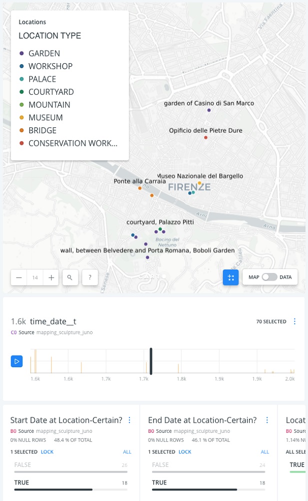
Fig. 4. Locations of Juno Fountain sculptures, filtered for precise date, 1579-2017. Map created by Catherine Walsh using CARTO, 2018.
Data curation, visualization strategies of GIS, and digital ontologies embedded within them can be employed to describe such varied and uncertain geographical statuses.[30] For example, within the dataset, I have included fields such as “date_certain” to help account for chronological uncertainty and “location_precise” for geographical precision. Filled with either “Y” for “yes” or “N” for “no,” these fields can be used to filter the visualization for sculptures whose locations are known with relative certainty within a particular temporal range (Fig. 4). It is also possible to custom design map legends within CARTO and other mapping platforms in order to suggest degrees of temporal and locational certainty. However, these strategies do not acknowledge that the identification of these geographical statuses represents acts of interpretation; deciding which metadata to include and how to organize metadata also requires interpretation. Johanna Drucker has repeatedly addressed these issues and has asked digital humanists to think about various acts of interpretation involved in constructing knowledge, and about how digital visual frameworks, including geographical ones, might be reconceived to better accommodate humanistic inquiry and qualitative interpretation.[31]
Soldini’s 1789 misidentifications of the Parnassus and Ceres figures stand as two extreme examples of historical misinterpretation.[32] That the titles he used—Arbia and Clemenza—are different from those traditionally accepted is indicated in the dataset, where I have included this information in the fields “alternative_title” and “alternative_title_dates.” However, how the process of identification/misidentification/re-identification depends upon multiple instances of human interpretation is not reflected in the dataset or visualization. Design of the data scheme represents yet another interpretive act: the column names in the spreadsheet suggest to users of the data, “here’s what I thought was important relative to the objects described by the sources and, ultimately, for the visualization.”[33] How certainty and precision are calibrated and defined is not visible; neither is the context of the description or depiction that aided the data curator’s interpretation.
Concerns about certainty, precision, and human interpretation might surface in any digital art history project, but in this example, they are amplified because of the “restless” and fragmented fountain, its inaccurate representations by artists, misidentifications by beholders, and scholarly debates about its original arrangement and iconography.[34] Drucker’s call to reimagine graphical representations of humanities data finds a well-suited case study in the Juno Fountain. One could conjure a geographical digital environment in which movement is calibrated to (described) states of visibility and disappearance, restlessness and stasis, fragmentation and wholeness.
Reconciling Place and Space: Granularity, Scale, and Movement
Instead, conventional chronological and geographical concepts define the visualizations examined here. Whereas the preceding section dealt with theoretical concerns about the sculptures’ ontology and that of the data, in the paragraphs that follow I consider practical challenges of reconciling location data for this project.[35] Between 1635 and 1789, the sculptures inhabited the Palazzo Pitti courtyard terrace briefly, the Casino di San Marco garden for about a century, and the Boboli Garden for fifty years.[36] While the placement of all nine parts on the terrace is described by multiple sources and depicted in multiple artworks,[37] comparable data about the placement of the sculptures in the Casino di San Marco garden and the Boboli Garden have not come to light. Thus, the act of mapping the sculptures’ presence in these three spaces relies upon diverse metadata that do not meet the same standard.
Sometimes sources describe locations with granularity equivalent to modern street addresses. For example, the fountain’s installation on the Palazzo Pitti terrace can be located with relative precision. Multiple early modern visual sources describe its position. Justus Utens’ painted lunette (1599) depicts the fountain on the terrace, in the horizontal center of the composition, below Giambologna’s Oceanus Fountain (c. 1575) and the amphitheater meadow. Soldini’s plan of the Boboli Garden (1789) indicates the location of the terrace above the courtyard (marked with an “X” shape on the left side of the image) and surrounded by a schematically depicted staircase. While it does not clearly depict the terrace or the fountain, Stefano Buonsignori’s map (1584, 1594) describes the relationship of the palace and garden to the city of Florence, helping the viewer understand the larger spatial context. Each of these images presents the fountain at a different scale and to a different degree of visibility, but together they help assemble an accurate understanding of its location. Moreover, the palace and courtyard terrace still exist, and appear to maintain the same layout today as they did in the period under consideration. Sources report that the Juno Fountain was removed from this place so that the Artichoke Fountain, still in situ, could replace it. Thus, two methods confirm the Juno Fountain’s seventeenth-century location: first, georectifying early modern sources representing the fountain’s location, and second, determining the GPS coordinates (43.764684, 11.250516) of the fountain currently in its place.[38] As discussed above, all nine components were located at this place in 1635, and so this metadata can be used for all nine entries in the dataset.
Location metadata for the sculptures from the time they were moved from the courtyard terrace (between 1635 and 1637) until 1789 are fuzzier. Multiple primary sources from this period contain descriptions of the fountain sculptures; these descriptions locate the sculptures in the Casino di San Marco garden and in the Boboli Garden. The sources characterize the sculptures in different ways: as part of the fountain commissioned by Cosimo I de’ Medici; as sculptures made for the Medici palace; and as sculptures seen near Palazzo Pitti.[39] Like the visual evidence from the sixteenth century, these written accounts of the sculptures’ whereabouts during the seventeenth and eighteenth centuries contain metadata of varying quality. The title of the fountain and its parts are not consistent among all descriptions, and the location information found in them inhabits a spectrum of specificity. These descriptions do not make clear that all nine components were located in the Casino di San Marco garden prior to moving to the Boboli Garden, though scholars have inferred that this was the case.
In 1677, Giovanni Cinelli wrote that “three figures” comprised an altered version of the fountain; he implied these were Ceres, Arno, and Parnassus but did not name them. In a subsequent description of sculptures at Pratolino, Cinelli listed all six figures, but as Heikamp pointed out, Cinelli did not seem to be aware that he described some of the same sculptures twice. In 1757, Cambiagi named one sculpture (Ceres, which he mistook for Clemenza) and referred vaguely to two others he knew Cinelli to have mentioned.[40] To my knowledge, visual depictions to reinforce and supplement these descriptions do not exist. Still, based on the information available, scholars accept that all of the sculptures existed together from 1637 to 1739 in the Casino di San Marco garden.[41] Yet in multiple ways location metadata for this period do not meet the same standards that location metadata for 1635 do.
Lastly, the space of the Casino di San Marco garden presents challenges. The current configuration of the site reflects multiple transformations during the past four centuries. Located across from San Marco and bounded by Via Cavour, Via San Gallo, and Via degli Arrazieri, the complex of buildings, courtyard, and garden spaces changed shape during the time the fountain sculptures were housed there. Comparing Buonsignori’s 1594 map and Ferdinando Ruggieri’s 1731 map, alterations to the complex are noticeable. Moreover, descriptions do not assign the fountain sculptures to specific locations within the garden. Thus, although the garden’s scale is suggested in these maps and can be estimated with GIS tools, it is impossible to generate latitude and longitude coordinates representing the sculptures’ locations in this space with the same precision of the GPS coordinates for the Palazzo Pitti courtyard location.[42]
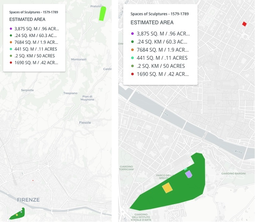
LEFT: Fig. 5. Estimated areas of spaces inhabited by Juno Fountain sculptures, 1579-1789. Map created by Catherine Walsh, using CARTO, 2018.
RIGHT: Fig. 6. Estimated areas of spaces inhabited by Juno Fountain sculptures, zoomed to the Florence city center, 1579-1789. Map created by Catherine Walsh, using CARTO, 2018.
Tracing the exact locations of the sculptures within the Boboli Garden between 1739 and 1789 is not feasible using known documentation. However, by 1789—as Heikamp discussed based on Soldini’s descriptions—all of the sculptures except for Juno seem to have been scattered about the garden. Yet as with the Casino di San Marco garden, the Boboli locations of all of the sculptures are not clear. The Casino di San Marco garden occupied perhaps a third of an acre within a city block, or perhaps less space than that; the Boboli Garden in 1789 measured close to 100 acres.[43] A huge shift in scale occurs between the Palazzo Pitti terrace (roughly a tenth of an acre), the Casino di San Marco garden, and the Boboli Garden; this problem of scale compounds that of fuzzy location metadata for some of the sculptures in the latter two spaces (Figs. 5 and 6). The dimensions of the Parnassus sculpture are 2.13 x .5 x .5 meters; roughly .25 square meter is required to accommodate the figure. Approximately 5,340 objects of these dimensions would fit into one third of an acre. Not only is the exact location unknown, but the possibilities are numerous.
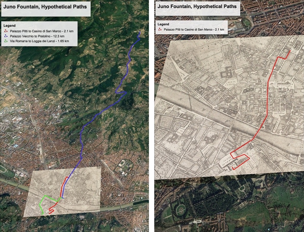
LEFT: Fig. 7. Hypothetical paths traveled by Juno Fountain sculptures, 1556-1789. Google Earth satellite imagery and georeferenced historical map, Ferdinando Ruggieri, Pianta della citta di Firenze nelle sue vere misure colla descrizione dei luoghi più notabili di ciascun quartiere, Florence, 1731. Harvard Map Collection, Harvard Library. Map created by Catherine Walsh, using Harvard Geospatial Library and Google Earth Pro, 2018.
RIGHT: Fig. 8. Hypothetical path traveled by Juno Fountain sculptures, 1635/1739. Google Earth satellite imagery and georeferenced historical map, Ferdinando Ruggieri, Pianta della citta di Firenze nelle sue vere misure colla descrizione dei luoghi più notabili di ciascun quartiere, Florence, 1731. Harvard Map Collection, Harvard Library. Map created by Catherine Walsh, using Harvard Geospatial Library and Google Earth Pro, 2018.
Tracing paths that the sculptures traveled between these places presents another challenge. Though information describing the sculptures’ movements after 1635 is thin,[44] estimating distances traveled and time expended is possible by creating hypothetical routes based on roads existing during the seventeenth and eighteenth centuries.[45] For example, streets described on Ruggieri’s map provide a relatively direct route from Palazzo Pitti to San Marco: along Via Guicciardini, across the Ponte Vecchio, north on Via Calimala, behind the Baptistery, continuing on Via de’ Ginori to turn east on Via Guelfa and north on Via Cavour, arriving at the San Marco garden after a journey of approximately two kilometers (Figs. 7 and 8). Moving the sculptures along this route might have required as many as six oxcarts, or six trips, depending on whether multiple sculptures were moved in one cart or not, the precise configurations of the oxen teams, and how many teams were employed. One load of marble, one carrata, weighing roughly one ton (850 kg), required a few hours to travel one mile.[46] The sculptures weigh between half a ton and one ton each.[47] Thus, the sculptures could have been moved between these locations (in 1635/37 and in 1739) in one day. There are alternatives to this route, of course. Furthermore, the conventions of transportation over land during this period compound uncertainty about the itineraries. Paths were regularly revamped, even en route, for a variety of reasons including weather conditions.[48] We cannot know with certainty the routes the sculptures traveled; still, the exercise of visualizing hypothetical paths is worthwhile, for it provokes questions about the environmental impact of sculptures, vehicles, animals, and humans moving through urban and rural space.
Conclusions
Collectively, the sculptures experienced at least 82 transportation events and traveled along routes representing perhaps 50 kilometers in total distance. Over four centuries, individual sculptures existed for as little time as a few weeks and as much time as (possibly) 331 years at individual locations. These basic calculations prompt consideration of the significance of repeatedly transporting large, heavy objects over time, and of the individual sculptures’ long-term presence in outdoor locations. How did movement or stasis affect the sculptures and the spaces they traversed and inhabited? Guglielmo Galli’s conservation report for Parnassus makes locational significance clear: “This sculpture was located along one of the paths in the Boboli Garden, close to a wall. The surface was covered with lichens and other such formations usually found on marble surrounded by plants.”[49] Location had formal and ecological consequences: placement affected form, with green matter obscuring figural representation and compromising the sculpture’s surface. In this micro-system of sculpture and lichen, stony stuff harbored life, and in doing so (at least temporarily) acquired organic, locational markers.
Extending this line of inquiry, we could imagine that the presence of the sculpture also disrupted ecology at the location, affecting the formation of natural matter, such as lichen, as a result of the sculpture’s own repurposing. Eco-materially, the sculpture shaped and was shaped by place. In part because of this operation, it prompted documentation that captured the artwork-location relationship. In a similar way, the two-century disappearance of Juno attests to the ability of artworks to define and dissolve space, and vice versa.[50] Mapping the afterlife of these and other sculptures comprising the unsettled Juno Fountain draws attention to the status of knowledge about them; to how that knowledge gives form to a spatial historical locomotive spectrum; and to the visibility and invisibility of the artwork and its locations. The digital geographical visualizations reinstantiate this artwork’s presence—and absence—through space and time in a manner that captures the definition and dissolution of locations no longer inhabited by its sculptures.
Catherine Walsh is Assistant Professor of Art at the University of Montevallo
Acknowledgments: The author wishes to thank the editors and two anonymous peer reviewers for insightful comments that significantly improved this article. Portions of the article were presented at Villa I Tatti in May 2017 and at Brown University in September 2017, and I am grateful for the feedback I received from participants at both events. Many thanks to Andrew Battista and Jodi Cranston for their generosity, as well as Bonnie Gordon, John Hunt, Lukas Klic, and Edward Wouk for the suggestions and resources shared with me.
[1] Detlef Heikamp, “Ammannati’s Fountain for the Sala Grande of the Palazzo Vecchio in Florence,” in Elisabeth Blair MacDougall, ed., Fons Sapientiae: Renaissance Garden Fountains (Washington, D.C.: Dumbarton Oaks, Trustees for Harvard University, 1978), 116-176. For recent summaries, see Cristina Acidini, “Fontana di Sala Grande o Fonte di Giunone,” in Cristina Acidini and Giacomo Pirazzoli, eds., Ammannati e Vasari per la Città dei Medici (Florence: Edizioni Polistampa, 2011), 184-185; and Emanuela Ferretti, “Bartolomeo Ammannati, La Fontana di Sala Grande e le Trasformazioni del Salone dei Cinquecento da Cosimo I a Ferdinando I,” in Beatrice Paolozzi Strozzi and Dimitrios Zikos, eds., L’Acqua, La Pietra, Il Fuoco: Bartolomeo Ammannati Scultore (Florence and Milan: Giunti, 2011), 136-155. For the documents, see the appendix in Heikamp, “Ammannati’s Fountain,” 153-173; and further discussion and excerpts in Ferretti, “Trasformazioni.” For discussion of the quarrying and movement of the marble blocks, see Hildegard Utz, “A Note on the Chronology of Ammannati’s Fountain of Juno,” The Burlington Magazine 114:831 (1972), 392, 394-395.
[2] Heikamp, “Ammannati’s Fountain,” 145.
[3] For the key reconstructions, see Marco Dezzi Bardeschi, “Una fontana dell’ Ammannati per Cosimo I,” in Bollettino degli Ingegneri, V (1969), 18-24; Heikamp, “Ammannati’s Fountain;” and, most recently, Giorgio Verdiani, Giacomo Pirazzoli, and Giada Cerri, “The Reconstruction of the ‘Fontana di Sala Grande’: And some hypothesis about its original layout,” Proceedings of the 18th International Conference on Virtual Systems and Multimedia (2012), 383-390. The Juno in the current reassembly is a copy, as the original could not safely rest atop the arc; the arc is a reconstruction, as the original was never found.
[4] Consider also objects like Paolo Veronese’s Petrobelli Altarpiece (c. 1563), cut apart to be sold as multiple paintings in 1788-1789 and only recently (mostly) reconstructed. See Xavier F. Salomon, “Reconstructing Veronese’s Petrobelli altarpiece,” The Burlington Magazine 151:1270 (2009), 4-13.
[5] Friedrich Kriegbaum, “Ein verschollenes Brunnenwerk des Bartolomeo Ammanati,” Mitteilungen des Kunsthistorischen Institutes in Florenz 3:3 (1929), 71-103.
[6] Kriegbaum, “Brunnenwerk,” 74.
[7] Kriegbaum, “Brunnenwerk,” 73-74.
[8] Heikamp, “Ammannati’s Fountain,” 120.
[9] In 1938, the Juno figure was located by Giovanni Poggi in storage at the Opificio delle Pietre Dure. Bertha Harris Wiles, The Fountains of the Florentine Sculptors and their Followers, from Donatello to Bernini (Cambridge, MA: Harvard University Press, 1933), 43. The peacocks were initially seen but dismissed by Kriegbaum; in 1968 Heikamp determined that these same objects, which he discovered at the same location as Kriegbaum had, were part of the fountain group. Heikamp, “Ammannati’s Fountain,” 117-118.
[10] See note 1, above.
[11] Possibilities for installation sites include niches adjacent to the courtyard staircase, beside the entrance to the rooms of Leo X, or at the entrance to the studiolo of Francesco I. Zikos, “Simbolismo,” 161. See also Hildegard Utz, “Bartolomeo Ammannatis Brunnen der Juno: Geschichte, Rekonstruktion und Deutung,” Scritti Di Storia Dell’arte in Onore Di Ugo Procacci 2 (1977), 381-407.
[12] Heikamp, “Ammannati’s Fountain,” 138-145.
[13] Heikamp, “Ammannati’s Fountain,” 133.
[14] Heikamp, “Ammannati’s Fountain,” 140.
[15] Heikamp, “Ammannati’s Fountain,” 145.
[16] On concepts of reuse, see Dale Kinney and Richard Brilliant, eds., Reuse Value: Spolia and Appropriation in Art and Architecture from Constantine to Sherrie Levine (Farnham: Ashgate, 2011). On the fragment’s relationship to the whole (especially from the late eighteenth century forward), see Ian Balfour, “‘The Whole is the Untrue’: On the Necessity of the Fragment (after Adorno),” in William Tronzo, ed., The Fragment: An Incomplete History (Los Angeles: Getty Research Institute, 2009), 83-91. An important distinction here is that the fountain parts represent whole, intact figures, not partial ones; still they are only parts of a dismantled whole work.
[17] Caterina Caneva, The Boboli Gardens (Florence, Italy: Becocci, 1982), 22. See the vague description of the sculptures’ move to the Boboli amphitheater meadow in 1739, and also the more particular descriptions of Arno, Parnassus (Arbia), Ceres (Clemenza), and Temperance (moved to various parts of the garden by 1789) in Francesco Maria Soldini, Il Reale Giardino di Boboli nella sua Pianta e nelle sue Statue (Florence, 1789), 16, 42-43, 53-54, 58-59. Soldini does not accurately identify the artist and makes errors in identifying the subjects of some of the sculptures.
[18] See my earlier discussion on alternative locations for Florence and Temperance, and note 12 above.
[19] Heikamp, “Ammannati’s Fountain,” 120-121, 138-139, 143-144.
[20] Gaetano Cambiagi, Descrizione dell’ Imperiale Giardino di Boboli (1757), 31-32; Heikamp, “Ammannati’s Fountain,” 145, 171.
[21] Other descriptive information such as the names given to the nine distinct objects at different points in time, the measurements of the sculptures (when available), and comments about the sources and the perceived degree of certainty or precision about the metadata therein are included; primary source place descriptions are supplemented by modern place names and latitude and longitude coordinates; and each entry contains ID numbers linking this dataset to the larger Mapping Sculpture dataset (indicated with “ms_”, my long-term digital mapping and research project from which this is drawn) as well as to Linked Open Data, such as The Virtual International Authority File (VIAF) and Getty Union List of Artist Names (ULAN).
[22] See notes 18 and 21, above.
[23] Beyond the acts of mediation that occur before the information takes digital form, the digital representation also signifies multiple things that any single datum is. For a concise discussion of this see Trevor Owens, “Defining Data for Humanists: Text, Artifact, Information or Evidence?” Journal of Digital Humanities 1:1 (2011), http://journalofdigitalhumanities.org/1-1/defining-data-for-humanists-by-trevor-owens/.
[24] See Johanna Drucker, “Digital Ontologies: The Ideality of Form in/and Code Storage—or—Can Graphesis Challenge Mathesis?,” Leonardo 34:2 (2001): 141-145; Valerie Allen, “Matter,” in Jeffrey Jerome Cohen, ed., Inhuman Nature (Washington, DC: Oliphaunt Books, 2014), 63, 73. For further discussion of the relationship between binary code underlying digital content and its role in abstraction, see Aden Evans, “Web 2.0 and the Ontology of the Digital,” DHQ 6:2 (2012) http://www.digitalhumanities.org/dhq/vol/6/2/000120/000120.html.
[25] See Ian Gregory, “‘A Map is Just a Bad Graph’: Why Spatial Statistics are Important in Historical GIS,” in Anne Kelly Knowles, ed., Placing History: How Maps, Spatial Data, and GIS Are Changing Historical Scholarship (Redlands, CA: ESRI, 2008), 124-149.
[26] The following ecotheory and material theory texts inform this project: Jane Bennett, Vibrant Matter: A Political Ecology of Things (Durham: Duke University Press, 2010); Serenella Iovino and Serpil Oppermann, “Stories Come to Matter,” in Material Ecocriticism, ed. Serenella Iovino and Serpil Oppermann (Bloomington: Indiana University Press, 2014), 1-20; Jeffrey Jerome Cohen, Stone: An Ecology of the Inhuman (Minneapolis: University of Minnesota Press, 2015). In addition, see the recent collection edited by Christy Anderson, Anne Dunlop, and Pamela H. Smith, The Matter of Art: Materials, Practices, Cultural Logics, c. 1250-1750 (Manchester: Manchester University Press, 2015).
[27] Google Sheets software organizes the metadata for this project. Spreadsheets are linked to the CARTO mapping platform. The sheets are used like a database, though they do not constitute a database technically. For a discussion of database design and data modelling, and further bibliography, see Stephen Ramsay, “Databases,” in Susan Schreibman, Ray Siemens, John Unsworth, eds., A Companion to Digital Humanities (Oxford: Blackwell, 2004), http://www.digitalhumanities.org/companion/.
[28] Zikos, “Simbolismo,” 157.
[29] Drucker, Knowles, and others have written about the tension between humanities data and digital graphical systems (from metadata requirements therein to the displays themselves), including GIS, and about the potential problem of users seeing digital map-as-truth. The map created for this study includes filters for the certainty and precision of locations and dates that can help users see that a spectrum of kinds of knowledge exists, but the effectiveness also depends upon the user’s ability to understand and navigate these features.
[30] Drucker, “Digital Ontologies;” Evans, “Web 2.0;” Lev Manovich, The Language of New Media (Cambridge, MA: MIT Press, 2001); Alan Liu, “Transcendental Data: Toward a Cultural History of Aesthetics of the New Encoded Discourse,” Critical Inquiry 31:1 (2004), 49-84.
[31] For instance see Johanna Drucker, “Humanities Approaches to Graphical Display,” Digital Humanities Quarterly 5:1 (2011), http://www.digitalhumanities.org/dhq/vol/5/1/000091/000091.html.
[32] See note 18, above. Note also that in recent scholarship the titles of individual figures are not consistently applied.
[33] Within the data scheme, more instances of interpretation occur: how information about time is described, which unit of measurement is used, if measurement is converted from inches to centimeters, and perhaps more obviously when assigning levels of precision and certainty to data.
[34] Neither Justus Utens’ painting (1599) nor Giovanni Guerra’s drawing (1598?) represent the sculptural group in a way that correlates with the archival record. Undoubtedly among others, Giovanni Cinelli (1677), Soldini (1789), and Kriegbaum (1927) misidentified or failed to identify various individual sculptures and/or the artist. See Heikamp, “Ammannati’s Fountain,” 118, 144, 146; Soldini, “Boboli,” 42-43, 53-54, 58-59; Kriegbaum, “Brunnenwerk,” 75-78.
[35] On the perennial challenge of precisely denoting place in digital history projects, see Anne Kelly Knowles, “GIS and History,” in Anne Kelly Knowles, ed., Placing History (Redlands, CA: ESRI, 2008), 1-25; David J. Bodenhamer, “History and GIS: Implications for the Discipline,” in Knowles, Placing History, 219-234.
[36] Within the Boboli Garden, the sculptures moved around until at least the nineteenth century, and at least seven parts of the artwork remained there until they were taken into the Bargello.
[37] Heikamp, “Ammannati’s Fountain,” 143-144.
[38] Using the DECIMA project’s georeferenced Buonsignori map and measurement tool, it is also possible to find the latitude and longitude coordinates for this location. However, because of the extant terrace and Artichoke Fountain, and because the Juno Fountain is not depicted on the Buonsignori map, it is perhaps slightly more direct and precise to use the coordinates for the Artichoke Fountain directly from Google Earth. https://decima-map.net/
[39] Heikamp, “Ammannati’s Fountain,” 169-171.
[40] Heikamp, “Ammannati’s Fountain,” 171.
[41] For one, Heikamp’s history of the fountain suggests that all of the sculptures moved to and from the Casino di San Marco garden together.
[42] See Stuart Dunn, “Space as an Artefact: A Perspective on ‘Neogeography’ from the Digital Humanities,” in Simon Mahony and Gabriel Bodard, eds., Digital Research in the Study of Classical Antiquity (Farnham and Burlington: Ashgate, 2010), 53-69.
[43] These approximate measurements were acquired using the DECIMA Buonsignori map and its measurement tool. Garden of Casino di San Marco: .1 – .33 acre, depending upon boundaries; Boboli Garden: 91.2 acres, roughly; Palazzo Pitti terrace: .11 acre.
[44] Meanwhile, correspondence indicates partial routes the marble traveled following quarrying and during sculpting at two different workshop locations. Kriegbaum, “Brunnenwerk,” 72; Utz, “Chronology,” 394.
[45] To create visualizations of hypothetical routes, Ferdinando Ruggieri’s 1731 Pianta della Citta di Firenze (georeferenced by the Harvard Geospatial Library and downloaded from the HGL site) was imported as a .kml file to Google Earth Pro. Paths were drawn and measured in Google Earth Pro, and then a KML file for each route was exported from that platform and imported into CARTO.
[46] For a description of the overland journey of marble from quarries to the Florence city center, see William Wallace, Michelangelo at San Lorenzo: The Genius as Entrepreneur (Cambridge and New York: Cambridge University Press, 1994), 57-61. To travel 15 km (9.3 miles approx.) required 1-2 days. Also see John Ward-Perkins, “Quarries and Stoneworking in the Early Middle Ages: the heritage of the ancient world,” in Artigianato e tecnica nella società dell’ alto medioevo occidentale 2 (Spoleto, 1971), 525-544.
[47] Verdiani, et. al., “Reconstruction,” 387.
[48] Fernand Braudel, Civilization and Capitalism, 15th-18th Century, Vol. I. The Structures of Everyday Life: The Limits of the Possible, trans. Siân Reynolds (New York: Harper & Row, 1981), 415-418.
[49] Guglielmo Galli, “Restoration Report of the Fountain Figures,” in Heikamp, “Ammannati’s Fountain,” 150.
[50] Thanks to Jodi Cranston for our discussion that inspired this turn of phrase.
Cite this article as: Catherine Walsh, “Unsettled Sculptures: Mapping the Afterlife of Ammannati’s Juno Fountain,” Journal18 Issue 5 Coordinates (Spring 2018), https://www.journal18.org/2678. DOI: 10.30610/5.2018.2
Licence: CC BY-NC
Journal18 is published under a Creative Commons CC BY-NC International 4.0 license. Use of any content published in Journal18 must be for non-commercial purposes and appropriate credit must be given to the author of the content. Details for appropriate citation appear above.