
Camille Mathieu
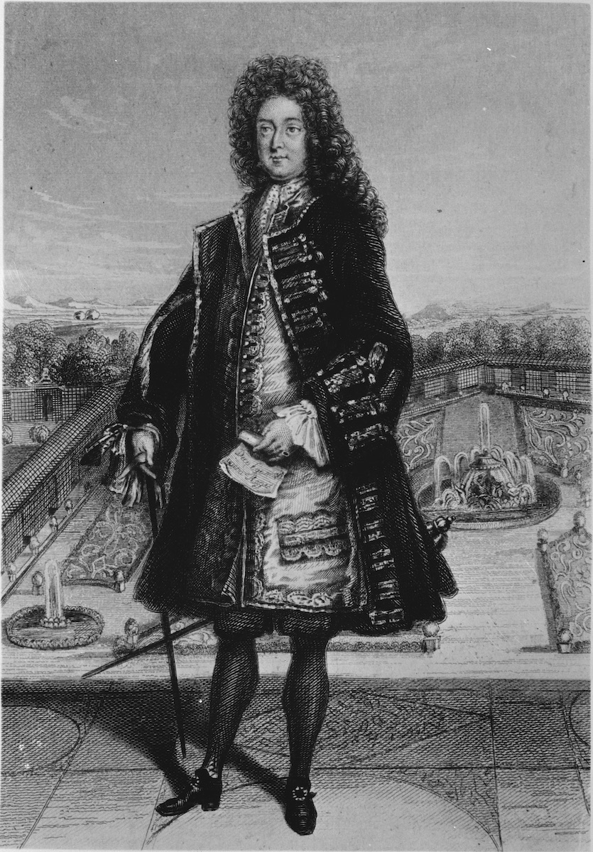
In a famous 1720 portrait of Scottish financier John Law, founder of France’s first bank (1716) and the Company of the West (1717), he stands in courtly dress in front of a well-manicured, formal French lawn (Fig. 1).[1] His dignified attire matches that of the orderly garden; his clothes are festooned with gold brocade while the garden is adorned with stately fountains, acanthian-scrolled parterres, and topiary trees. Both environment and man are contemporarily modish, consistent with the imagery of current fashion plates which showed courtiers, resplendent in silk and lace, posing in Le Nôtre-styled lawns. The gardens depicted in fashion plates, however, rarely offer such a distant perspective as the one afforded here; beyond the carefully trellised walkway defining the garden’s limit bursts a dense forest. The forest gives way to a plain above which rise craggy mountains, whose range seems to span the entire background behind Law. The mountains are the most contrived element of the image, for none of the gardens that Law was most likely to frequent in Paris or Versailles would have had such pronounced and particular topography.
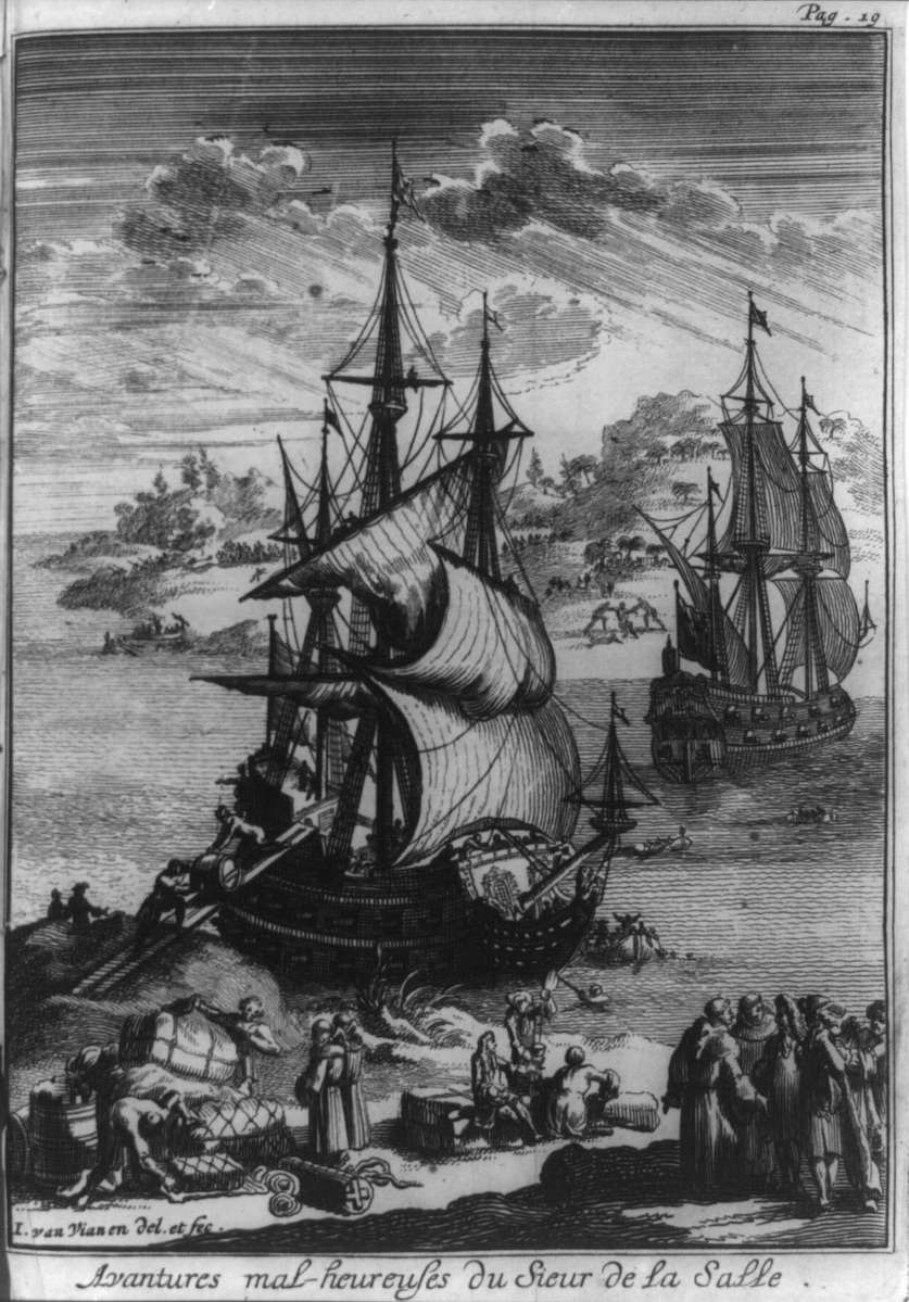
Instead, the mountains here resemble those marshaled to depict Louisiana’s fecundity and wildness in images produced in this period, both as promotional publicity for Law’s Company and independently. For example, a mountainous coastline dominates the background of a 1698 Van Vian print of explorer Robert Sieur de La Salle’s ill-fated attempt to colonize Louisiana in 1684 (Fig. 2). Though not geographically accurate (La Salle’s expedition mistakenly anchored in Texas’s Matagorda Bay), the mountains here indicate the foreignness and hostility of the terrain, their tree-lined tops cresting towards the downpour of rain promised by the heavy, gathering clouds. At the base of mountains, two men attack a third—foreshadowing La Salle’s murder at the hands of his own men after he failed to find the mouth of the Mississippi. As in John Law’s portrait, the seemingly rationally organized environment of the European Enlightenment—present here in the ample supplies piled ashore as well as in the outwardly disciplined sailors and settlers surrounding them—gives way quickly to an untamed, uncontrolled (and, in Louisiana, uncontrollable) terrain.
Louisiana’s wildness fostered imperial, economic, and geographic speculation. Contemporary scholarship on these related speculations tends to focus on France’s imperial ambitions for the New World, marshaling maps in order to explicate the ever-changing imperial boundaries and the “blank slate” aspect of as-yet unexplored territories.[2] I propose instead to begin with the visual outputs of geography—maps and their cartouches—and work backwards, investigating the shifting emphases of their imagery of Louisiana’s varied assets before 1720.[3] A map cartouche generally consists of a panel containing the map’s title and inscription, framed by decorative pictorial elements. Cartouches serve to magnify the map’s cultural message though allegory or illustration.[4] Drawing on cartographic scholar J.B. Hartley’s Foucauldian concept of “cartographic silence,” I interrogate the loudness with which authentic, natural abundance is claimed for Louisiana: first, in prints, maps, and travel narratives of the territory from the 1680s through the 1710s, and then, in John Law’s mobilization of, and eventual bodily incorporation into, this same discourse of plenty.[5]
In his propaganda materials—promoting Louisiana to the government, to Company concessionaires, and to potential settlers in France—Law innovatively equated Louisiana’s land and its resources directly with the money to be earned from investing in Company shares. Though the economic relationship between shares and land was far less straightforward, both were made to seem alike through Law’s promise of an outlandish reward for even the most minor effort or investment.[6] This bold strategy had the effect of inextricably linking the land to both Law’s person and to his economic system, itself called the Mississippi System for its perceived entanglement with Louisiana.[7] Law’s marketing of Company shares and concessions drew on long-standing ideals of the natural and labor-free bounty of America, a bounty he made more appealing by mythologizing, diversifying, and exoticizing it. However, his loudly proclaimed fantasies of easy money and effortless cultivation, like the maps that promoted them, deliberately stifled the grim realities of Eurocentric ‘discovery’ and exploitation narratives: that the success of French rule in Louisiana would be impossible without Indigenous knowledge, colonial warfare, and large-scale forced African or Indigenous labor.
Making Myths of Mountains, 1680-1717
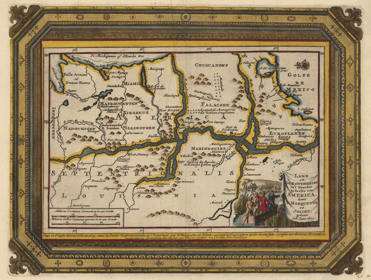
European maps of French Louisiana from the 1670s onward fostered myths of a natural, lucrative land mass while suppressing Indigenous intellectual contributions to the knowledge they represent.[8] Aspirationally relating Louisiana’s ore resources to those in New Spain, these maps were drawn to emphasize the ruggedness of the terrain as well as the proximity to New Mexico’s mountains.[9] A map documenting the early Mississippi River explorations of French-Canadians Father Jacques Marquette and Louis Jolliet in 1673 not only shows a southwestern tributary of the Mississippi, the Red River, running into Spanish New Mexico’s ore-rich peaks, but also represents the Mississippi River and its northernmost tributaries as being lined with mountain ranges (Fig. 3a). While parts of the Mississippi do in actuality abut prominent bluffs, drawing and labeling them as mountains (“Bergen”) speaks to an aspiration to mine wealth from the areas nearest to the River itself, the better to send the ore downriver quickly for export to France.
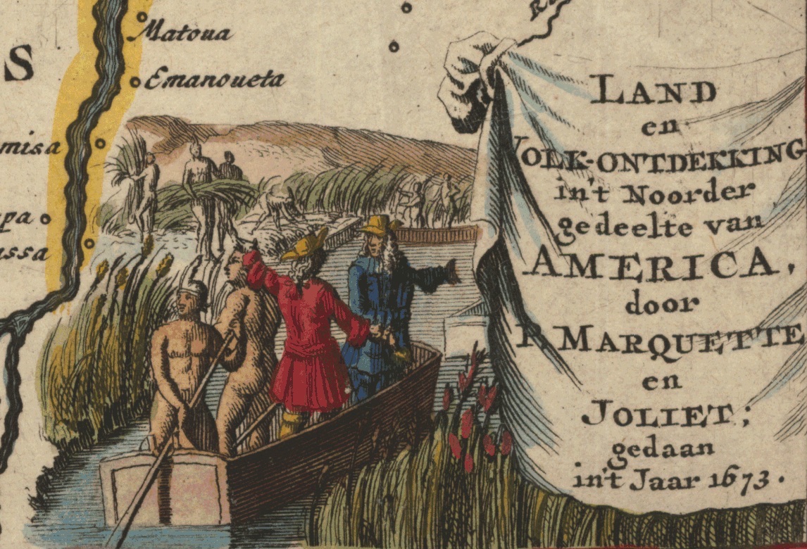
The map’s cartouche exoticizes exploration and exploitation even as it silences Indigenous power and knowledge (Fig. 3b). The high crags rising up from the riverbank in the background of the cartouche gesture at the natural mineral riches of the country. In their shadow, overdressed Frenchmen converse together, standing in a typical Mississippi flat boat as it is expertly piloted through the river’s cattails, or cane, by nude Indigenous men. Europeans here are seen playing at discovery, or supplanting Indigenous geographical knowledge with that of their own in a process that scholar Jean O’Brien has described as “firsting.”[10] The Frenchmen seem not to notice the Indigenous men clearing cane from the river in the background, reiterating the narrative that manual labor is performed by docile, willing, non-Europeans while the job of direction, of thought, and of naming is left to white explorers. The knowledge gained from Indigenous tribes encountered—including the enumeration of Tribal groups based along the river, a common feature of Louisiana maps—is suppressed, despite the cartouche’s emphasis on their manual labor. Indigenous men are visualized here as a means to the end of resource exploitation.
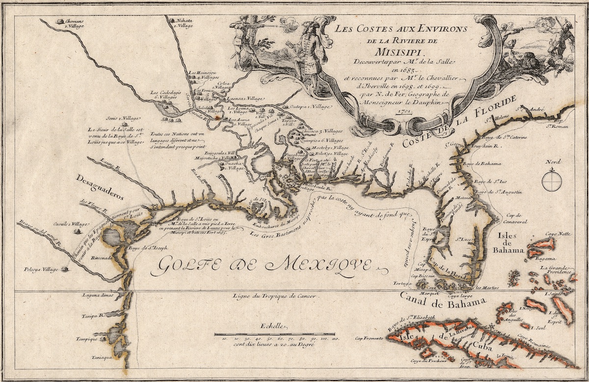
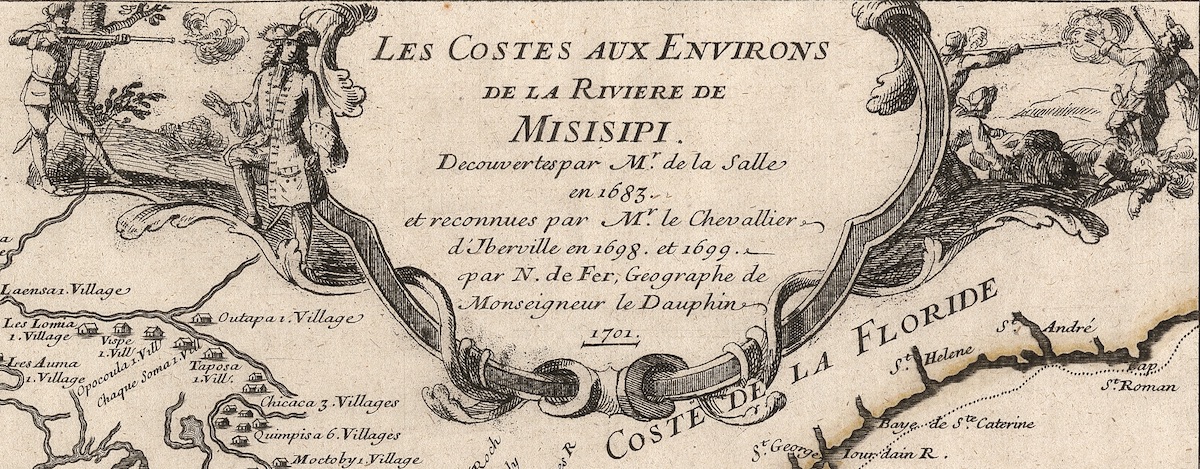
French geographer Nicolas de Fer’s 1701 map, documenting the same 1684 La Salle expedition as Van Vian’s earlier print, emphasized both Louisiana’s proximity to Spanish New Mexico’s ore-rich mountains as well as the geographic dominance of the Mississippi River watershed—and therefore France—over the Gulf Coast region (Fig. 4a). The map actually expands France’s territorial claims by placing sites established by La Salle on his disaster-filled journey to find the Mississippi River quite far to the west.[11] The cartouche depicts an event alluded to on the map itself by the abrupt ending of the line representing La Salle’s trek across what is now Texas: La Salle’s murder in the swampy coastal terrain at the hands of his own men (Fig. 4b). Behind this murderous scene rise the hills and mountains of New Spain, inaccurately but aspirationally. The La Salle and the Marquette/Jolliet cartouches embellish the imperial narrative of the maps they serve by projecting mountains full of ore—resources apparently worth dying for—in places where they do not actually exist. Yet, the positioning of these maps within scientific discourse serves to lend even greater support to the visual claims of the cartouches, with geographic information and visual imagery locked into a mutually reinforcing narrative.[12]
Cultivating Abundance: Text and Image
Louisiana’s imaginatively mapped mountains not only sustained but also helped amplify the illusion that wealth of all kinds was quickly and easily extractable from the land—this in opposition to a gradual build-up of capital over time through colonization, trade links, and agricultural exploitation. The royal mandates (Lettres patentes) issued to both Louisiana backers—first, financier Antoine Crozat in 1712, and then John Law in 1717—reflect the ways in which royal interest in Louisiana was fueled in part by this kind of speculative mapping. Crozat’s Lettres patentes specifically list gold, silver, precious gemstones, and pearls as products sure to be found in Louisiana.[13] While the 1712 Lettres also reference silk and indigo as potential exports, they do not account specifically for how those cash crops will be cultivated.[14] In contrast, Law’s 1717 Lettres offer a more diverse portfolio of resource exploitation. The goals of ore exploitation seem more modest in 1717; the crown expects to find principally copper and lead, as opposed to gold and pearls. However, the 1717 letters explicitly encourage cash crop cultivation right from the text’s preface, advocatingfor the transport of 6,000 white men (including indentured servants) and 3,000 enslaved Africans to Louisiana.[15] This shift in royal planning serves as an admission that ore findings alone would not render Louisiana profitable, yet still underrepresents the labor needed to support a plantation economy. The ideology of natural abundance that first manifested itself in the projection of ore resources on maps is, at the beginning of the eighteenth century, further projected onto agricultural exploitation.

Law’s Louisiana-specific Company propaganda, created from 1717-1720, was designed to attract both colonists and investors by painting the broadest possible picture of natural uncultivated wealth in Louisiana. To aid in his recruitment efforts, Law and his Company employed a multi-media approach, mobilizing maps, prints, and publicity tracts in multiple languages.[16] The most famous of the publicity texts include three embellished, if anonymous, travel narratives written from alleged eyewitness perspectives and published in the Nouveau Mercure from 1717 to 1719— one even claimed Louisiana could become “France’s Peru” on account of its riches.[17] A print by engraver François-Gérard Jollain distributed in Paris from 1717-1720 featured an image of colonists trading at the fictionally bustling port city of New Orleans (Fig. 5). The image is a useful lens though which to examine these Nouveau Mercure narratives, as it was most often reprinted with text below it repeating some of the journal’s more outrageous claims about Louisiana’s abundance.[18]
Jollain’s image portrays life in New Orleans, and consequently, Louisiana, as orderly: full of good social relations between French people of quality. This is articulated in the foreground of the image featuring finely dressed Westerners embracing one another in a well-regulated civic space. Local tribes are depicted as submitting peacefully to this social regulation; as noted in the Nouveau Mercure articles, their interests were not in warmongering, but in trading and in worshipping the God of Frenchmen.[19] Accordingly, at the left of the scene, Jesuit missionaries convert enraptured Indigenous Peoples to French Catholicism.
In Law’s publicity tracts, all potential threats—from rattlesnakes to violent Indigenous tribes to bears—are exoticized in their wildness even as they are proclaimed governable. Jollain’s image encourages this interpretation by reveling in the foreignness of the clothing and bodily decoration of the Indigenous Peoples present, while also displaying their ready submission to the “civilized” behavior of casually getting drunk with colonists.[20] At the right of the image, a Frenchman trades with an Indigenous hunter for specific articles mentioned in the articles of the Nouveau Mercure. Piled up in the foreground at the feet of the two men, wild suckling pig and all manner of dead game birds are exchanged for bright red cloth from France.[21] As Law’s propaganda texts promise, the Company of the West is shown providing the colony with necessary provisions for survival, showcased in the trade offerings of colonists and the barrels of alcohol in the foreground.[22]
Everywhere in Jollain’s image, there are signs of cultivation and of profit from the colony’s resources. The ore-heavy mountains, crop-saturated hills, fish-laden bay, and fruit-bearing palm trees signal the natural abundance surrounding the (mostly fictional) fortified city of New Orleans. The smoking pipe of the man at right—who, in some versions of the print, appears to be dark-skinned—indicates the successful cultivation of tobacco. Yet neither tobacco nor an extensive discussion of the labor that would be required to cultivate it appear in the Nouveau Mercure articles.[23] Even references to plantation culture, stressed repeatedly as a French royal goal in the 1717 Lettres patentes, are vague: for example, indigo’s natural ubiquity is mentioned frequently in the Nouveau Mercure articles, but the scale and method of potential cultivation is only obliquely addressed.[24] The Nouveau Mercure texts make no mention of enslaved Africans and only a passing reference to enslaved Indigenous Peoples, framing them simply as war booty.[25] Instead, then, of dwelling on the possibility of importing forced labor, the texts stress potential gains that could be achieved by advantageously trading with Indigenous Peoples for resources and tricking them into freely providing their labor to cultivate silk from the abundant mulberry trees. These, along with subsistence farming, were the chief commercial activities promoted by Law in Louisiana.[26]
The labor of erecting towns and plantations, and of cultivating native flora and fauna, is left ill-defined in these texts in part because the propaganda materials suggest that this work had been largely completed or would demand no effort. For example, the February 1719 Nouveau Mercure letter claims that, though one could easily find (white) indentured servants willing to immigrate to Louisiana to aid Frenchmen in setting up farms, it was sufficient (and indeed, general practice) for neighbors to help out one another only occasionally in order for the land’s wealth to be tamed into regulated productivity.[27] The bonhomie of life as described in Law’s Louisiana—“tranquility reigns here and society is enjoyable”—relies on the land’s overflowing bounty.[28] Its natural excess makes its cultivation easy and allows individual, lower-class, white Europeans upward mobility: “no one asks you for anything, and all that you possess is yours and you can live very independently.”[28] The letters thus reveal themselves to be aimed at two groups: ideal potential colonists, such as the skilled white European laborer, and wealthy prospective land or share buyers. The Nouveau Mercure’s conspicuous silence on the issue of African slavery, and even the feasibility of a plantation economy at large, is drowned out by the loudly extolled virtues of freely growing indigo and self-reliance.
Mapping Abundance: Law and De l’Isle’s Louisiana
The equation of the abundance promised by a share in Law’s Company with that naturally occurring in Louisiana’s terrain is made explicit in European maps of French North America and Louisiana produced from 1717 to 1720, in both the language employed on the landmass and in the maps’ visual decoration.[30] As maps of imperial territories are most likely to reference reigning sovereigns, the number that directly reference Law or his family—either in their dedications or their pictorial rhetoric—is a testament to his propagandistic talent. That is to say, by 1720, Law’s successful grafting of the image of a spontaneously flourishing colony onto a pre-existing mythology of superlative natural resources had become so inextricably linked with the hyperbolic rhetoric surrounding his Company’s profits that it caused geographic and economic speculation on Louisiana to remain intertwined long after the Mississippi Bubble had burst. In post-1720 maps, however, the poor management of the Company’s finances was also taken on, teleologically, by the land Law had failed to tame.
While most of the maps that feature Law tend to be of Louisiana and the adjacent British colonies, Law’s likeness itself is boldly inscribed into the cartouche of famed German engraver Gabriel Bodenehr’s General Map of North America (1718-1720). This map lacked the most recent geographical data, still showing California as a separate island (Fig. 6a).[31] Yet in the map’s geography, Law’s Louisiana dominates North America: the Mississippi River stands out prominently in its blank ground. As in the Marquette/Jolliet map, the Mississippi is lined with ore-rich mountains. Their wealth is reasserted by the map’s emphatic and unusual inclusion of the vast, gold-producing territories of New Spain in Central and South America. This geographic focus on wealth-generating territory is repeated in the cartouche (Fig. 6b). At its center is an oval portrait of John Law, styled similarly to a hand-held miniature. He is sumptuously dressed and holds out a blank piece of paper in his right hand, which might be an allusion to the paper trading of shares in his Company.[32] Above him is inscribed a Latin phrase implying that he should be greatly respected, an attitude that the starry-eyed men surrounding his portrait in the cartouche have adopted.[33]
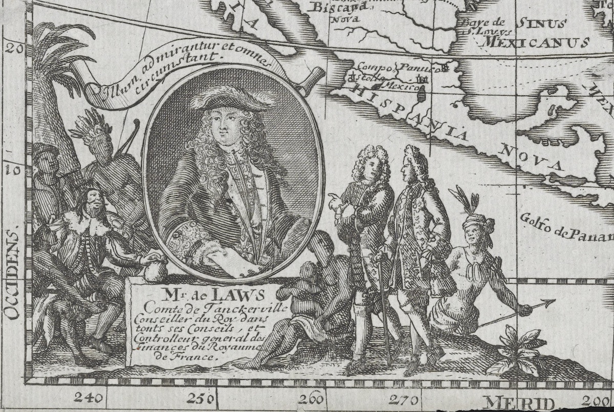
The individuals surrounding Law seem to be engaged in a kind of time-travelling fantasy of profit and exchange. The foreground of the cartouche features two well-dressed Frenchmen, conversing as they walk past the portrait and acknowledging Law’s presence by pointing at him. The Frenchmen, potentially themselves investors in Law’s Company, are regarded with curiosity by the figures neighboring them: an Indigenous woman, nursing a child, and a spear-wielding Indigenous man. By the eighteenth century, representing the continent of America as an Indigenous woman was a well-established convention in the print and map trade.[34] Smaller-scale, regional maps, however, often included images of “local” Indigenous people on the cartouches: an ethnographic gesture that lent the imperial enterprise the veneer of knowledge-furthering.[35]
In Bodenehr’s map, the representation of Indigenous Peoples draws heavily on popular Renaissance prints of the Tupinamba Tribe of Brazil; in the French imagination, this tribe had become a sort of generic stand-in for Indigenous Peoples of the New World after their encounters with the French in the 1500s.[36] Many of the Indigenous men and women in Jollain’s New Orleans print, for example, share the Europeanized iconography of Tupinamba traits: the women are bare-chested, and the men sport crowns of upright feathers.[37] Bodenehr’s shadowing schema seems to place the Indigenous Peoples at the cartouche’s right side further back in space and time than the Frenchmen in the foreground—they are primitivized by perspective. However, the contemporary fertility of the land and its link to Law’s scheme is visualized in the rich American soil that links all of the characters, upon which the nursing woman sits and from which a tobacco plant springs in the foreground.
The potential wealth Law’s Louisiana could generate is figured in the cartouche in more literal terms on the left-hand side of his oval portrait. There, an Indigenous man, carrying rolled up goods for trading—possibly animal hides—crouches near to the ground. Behind him stands a man in eighteenth-century lower-class dress whose race is difficult to distinguish since he, too, is in the primitivist shadows of the cartouche: perhaps an indentured servant or a settler. To the right of him is a crowned, standing Indigenous warrior, carrying a bow and drum of sorts. These three figures represent the enriching prospects of trade and colonial development. Seated in their midst is a white man with long black hair and an elaborate moustache, sporting sixteenth-century Spanish courtly dress, full lace ruff included. A profiteering conquistador, he holds a sack of gold in his hand and, like the other figures, stares reverently at Law. The conquistador represents the French hope that, under Law, Louisiana would become “France’s Peru.”[38] Reading the cartouche from left to right, Law could be interpreted here as bridging the gap between the legendary wealth of New Spain and the hoped-for wealth of French Louisiana.
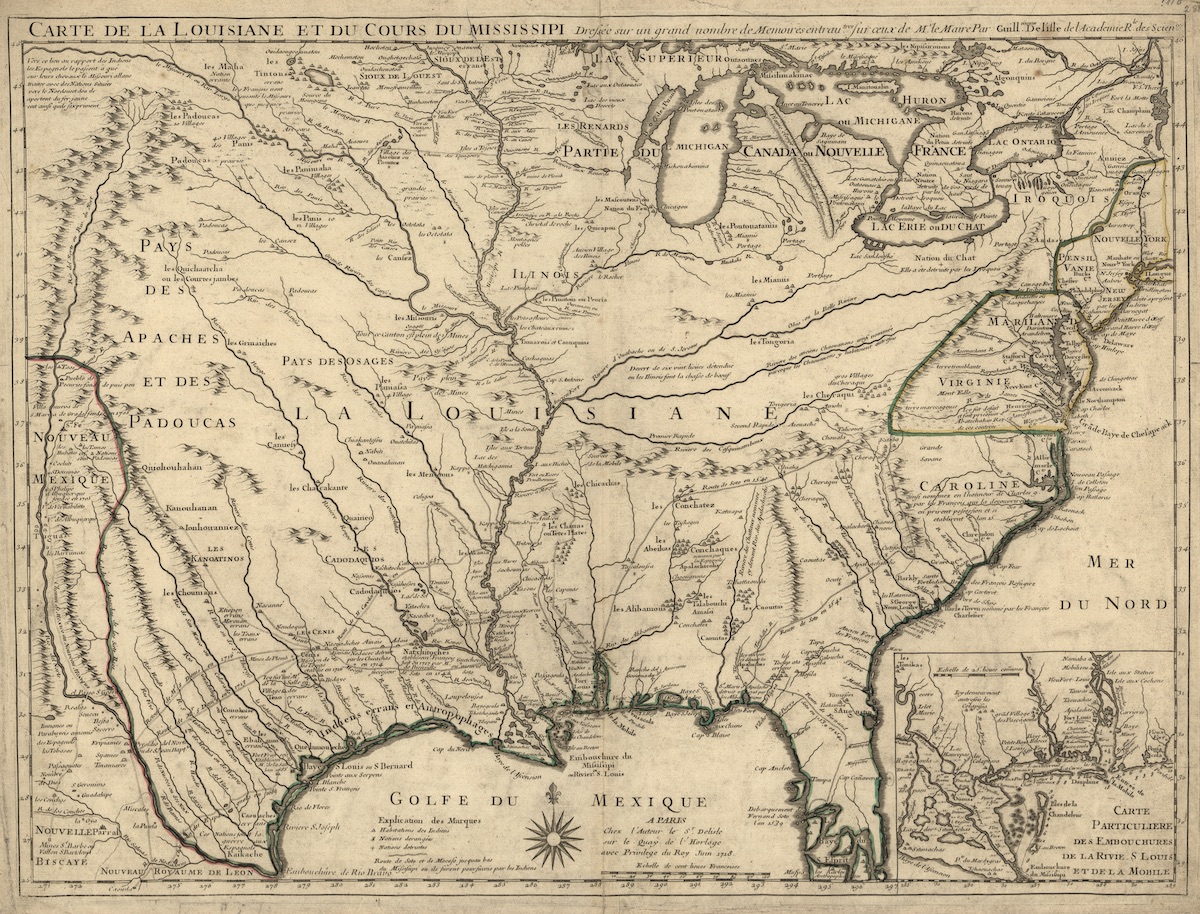
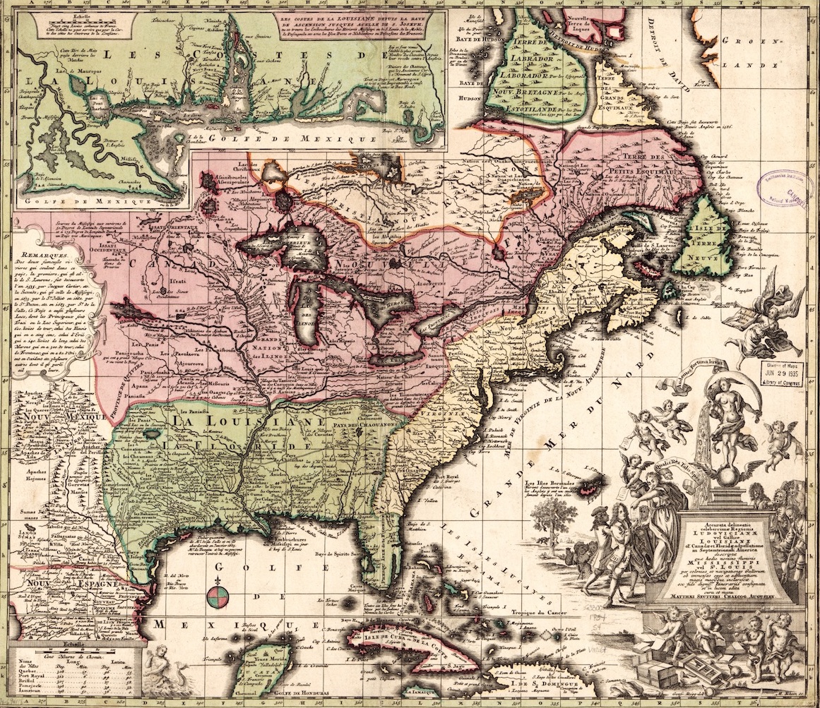
The monetary value of Louisiana’s distinct assets, as opposed to its historical place in the exploitation of the New World, is the subject of Guillaume de l’Isle’s well-known 1718 map of the colony (Fig. 7). De l’Isle first presented a version of this map to the Conseil de la Marine (the ministry of state) alongside a memorandum on the virtues of the land itself in October 1717.[39] Based in part on the rosy outlook and technical information imparted to de l’Isle by a famous missionary to Louisiana, François le Maire, the map is historically credited with re-igniting royal interest in the colony.[40] By 1718 when it was published, this map had become so inextricably linked to Law’s colonial enterprise that it was recopied and disseminated for foreign-language propaganda purposes by printmaker Christoph Weigel in 1718-1719, and again by English cartographer John Senex in 1719.[41] Unlike de l’Isle’s map, both the Weigel and Senex maps feature elaborate cartouches which enumerated, iconographically, their larger political, economic, and social ambitions. The later maps and their cartouches remained silent, however, on the imperative of forced labor to actualize these lofty goals. Information from de l’Isle’s map also helped to inform the speculative mapping of Nicolas de Fer, whose 1718 map of Louisiana was most likely the first to brand the New World with the coat of arms of the Company, while identifying it as such.[42]
The most common feature that later mapmakers borrowed from de l’Isle was the particular way in which he presented Louisiana’s terrain; the (too) broad reach of the Mississippi’s tributaries allowed him to inaccurately appropriate for France parts of the ore-rich New Mexico mountains and the fertile, tobacco-producing plains of the British Carolinas.[43] De l’Isle emphasizes the legitimacy of France’s geographic claims to this territory by including historic, nationalistic annotations: crisscrossing trails denote the successes of French explorers while the establishment of frontier cities like Natchitoches is proclaimed in loud, large writing.[44] Many of the Indigenous Tribes alongside the River are also specifically named, listed similarly to those in the Nouveau Mercure propaganda letters of 1717 and 1718.[45] Mapping these signs of French knowledge signaled that, while the region offered much to discover, it was ultimately knowable by Europeans and therefore could be successfully exploited.[46]
De l’Isle’s Louisiana is awash in mines and natural resources. The country between the Missouri and Arkansas rivers is even labeled “plein de Mines” twice in overlapping areas to underscore the abundance of mineral wealth. The Mississippi watershed claimed by France is again lined with mountains, but specific annotations in the territory itself reveal only the existence of the lower-grade metals named in the Law’s Lettres patentes—copper and lead. An allusion to the supposed gold trade between the Spanish and more northern tribes of Indigenous Peoples is offered in the text at the source of the Missouri.[47] Though the mines are the most visually apparent asset of the terrain, the Mississippi’s watershed itself is full of islets, tributary rivers, bluffs, and ecors on which the French have bestowed names evocative not just of French saints or royalty (Margot, Louis, Marie) but also, importantly, of local food sources and fauna. Place names reference tortoises, wild buffalo, deer, turkeys, salt, nanny goats, swallows, and flowers. Most of these terms imply Arcadian bounty, not danger; titles featuring snakes, crocodiles, and bears, animals which Law’s tracts deem to be exotically threatening but easily defeated, are rare. The French names of these geographical features—names which Senex’s English version does not contest but simply translates—reveal the extent to which the map reflects what Law’s Company stakeholders wanted to see.[48] “Turkey Point” or “Wild Buffalo River” are imagistic titles that feed imaginative visions of an undemanding, natural bounty.
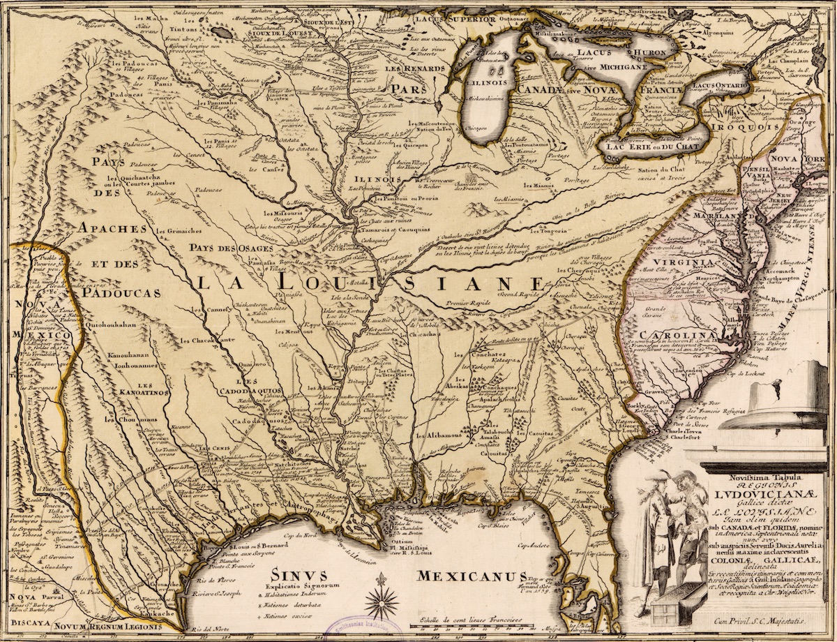
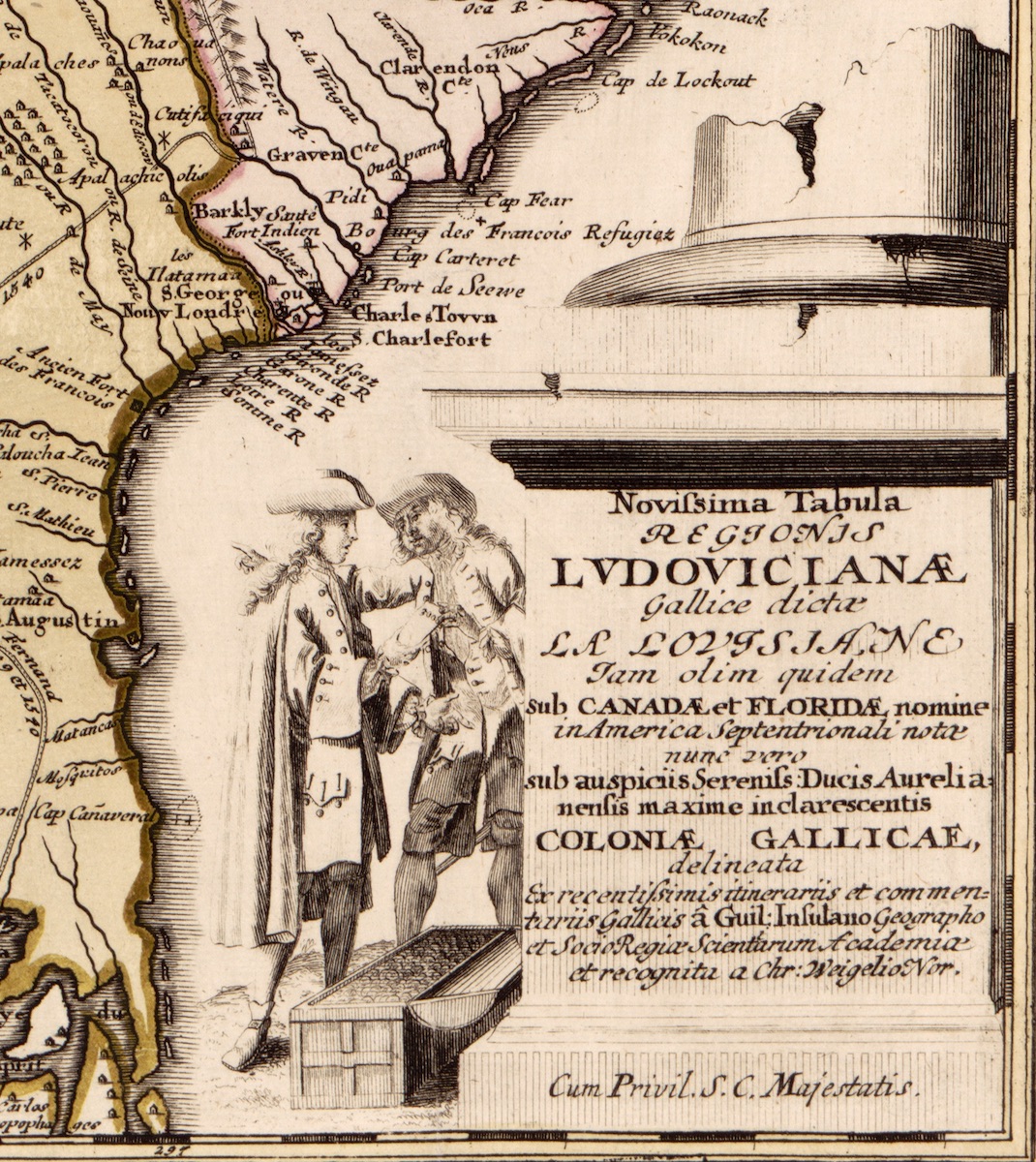
The easy prosperity inscribed in names or represented by ore-filled mountains in de l’Isle’s map is the subject of the cartouches in both Weigel’s (1718-1719) and Senex’s (1719) copies. These cartouches allow for the visual projection of fantasies that geographical information conveyed on the map can only point to. In these later maps, the cartouche performs the “discourse of power” by revealing, as if already actualized, the French imperial demands on the region.[49] Weigel was a known map and image engraver in Leiden; his map of Louisiana artfully illustrates the ways in which cartouche-making can effectively employ the decorative tropes of artistic engraving to spin myth from fact.
Weigel’s 1718 redesigning of de l’Isle’s map aggrandizes the French nation by titling the map with a lofty Latin inscription—lauding the Bourbons of France, and noting that Canada, Florida, and Louisiana are now part of their great colonial empire in America (Fig. 8a). This Latin text is placed into the plinth of a stately, if crumbling, column base, further elevating its message (Fig. 8b).[50] At the left of the neoclassically inspired inscription, two well-dressed Frenchmen, again engaged in conversation, stand over an open chest of gold coins. The cloak-wearing man with his back to the map receives from the other a slip of paper inscribed with the number 3,000. The open-mouthed incredulity of the man at left, along with his downward pointing gesture, implies that the chest of gold is equivalent to the paper in his right hand—the surprising price for 3,000 shares in the Company of the West. The man at the right dispensing the shares reassures the buyer of the great value of his purchase through a similarly equalizing gesture: between the 3,000 shares and the territory of Louisiana, towards which his right arm points in a not dissimilar way to the Frenchmen in Bodenehr’s map, pointing to Law’s portrait. The real fortune, the seller suggests, is to be found in the land of Louisiana itself and its plentiful resources. Weigel’s map, which translates key passages relating to mining resources into Latin, was most likely aimed at German investors and colonists, just over a thousand of whom had immigrated to Louisiana by 1722.[51] The visual detail of the coffer full of money helps reinforce the link between Law’s banking scheme and the colony’s land; both are homologous in their certain abundance.
Senex’s 1719 map builds on the information copied from de l’Isle, further specifying the nature of Louisiana’s bounty by pointing to agricultural and mining sources of wealth in its cartouche (Figs. 9a and 9b). At the expense of the Bourbons, Senex dedicated his map to John Law’s (Scottish) brother, “William Law of Lauriston,” directly linking both Laws to the land depicted. This dedication and the hyperbolic, elaborate visual vocabulary used in the cartouche seem to have ensured that its iconography would later be re-used to denigrate John Law after his downfall.
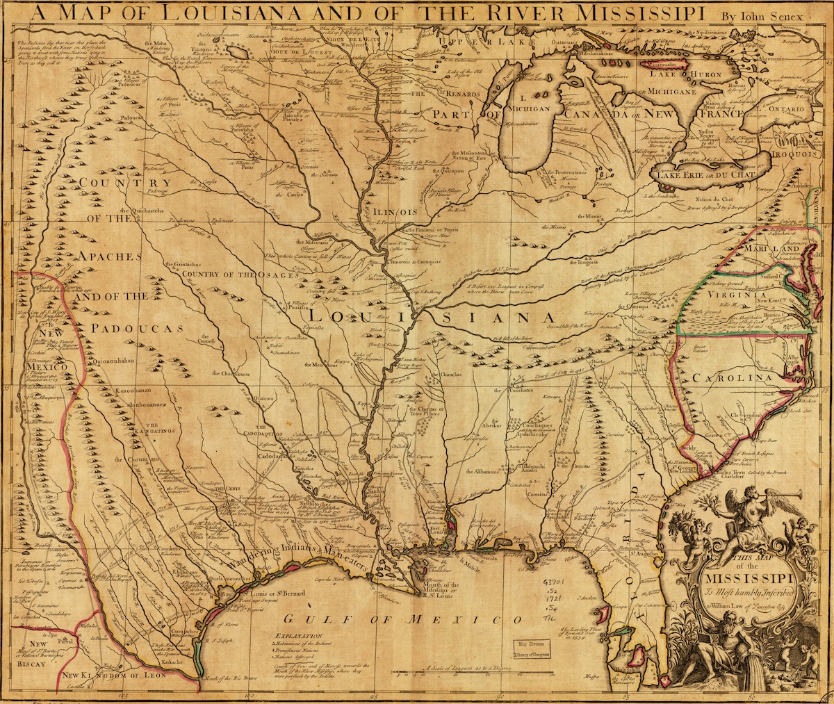
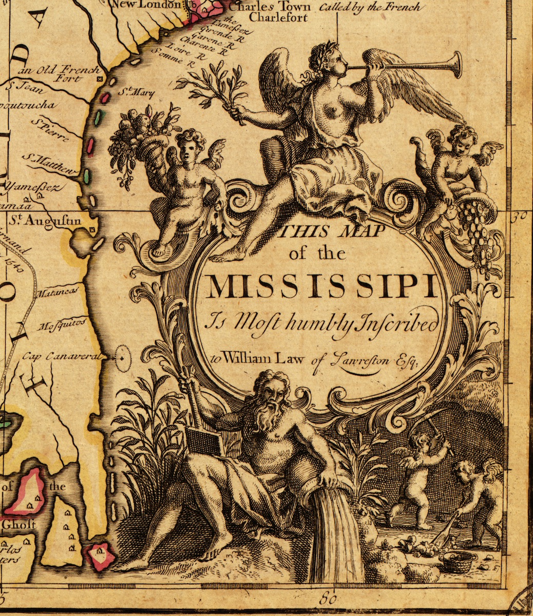
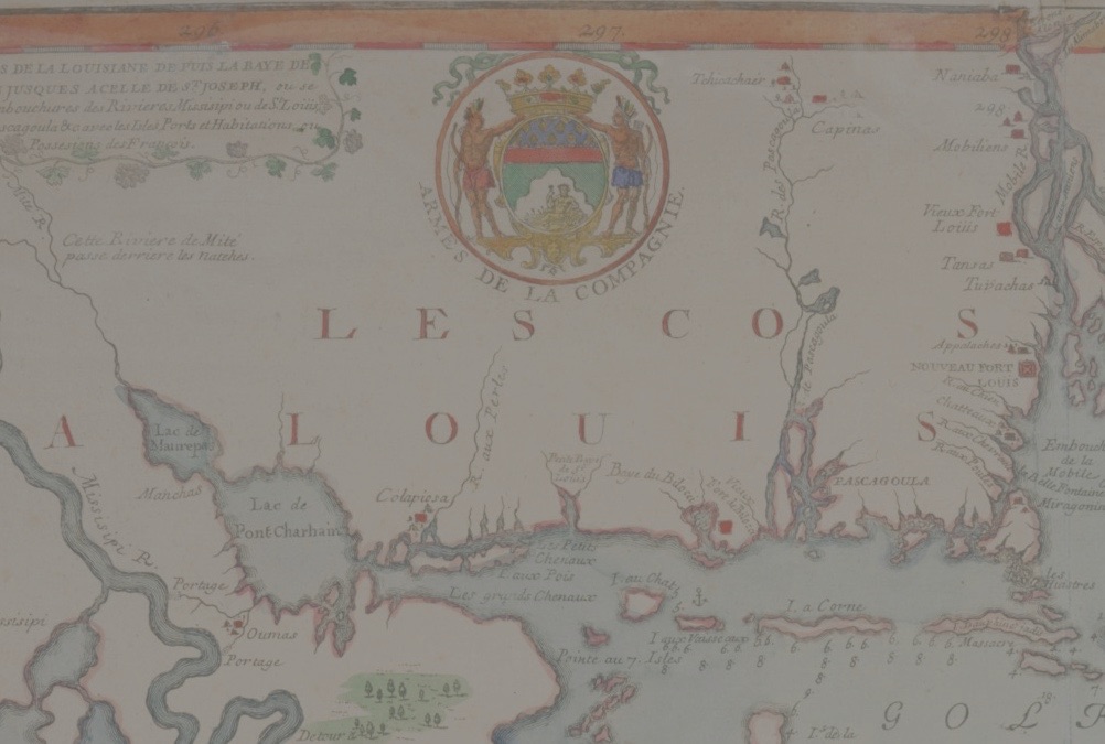
No doubt in tribute to Law, the cartouche appropriates and develops aspects of the Company of the West’s imagery (Fig. 10). The Company’s seal, dictated by the King in the 1717 Lettres patentes, consisted of two Indigenous men (called “sauvages” in the text) holding up a crest with a nude representation of a river god; he reclines on a golden cornucopia, above which is placed a band of golden fleur-de-lis in a blue background, topped by a golden crown.[52] In the Senex cartouche, the Company seal’s Indigenous men—a potential labor force for the colony, those who revealed and assured its riches—are replaced by insouciant, white, winged cherubs. The cornucopia in the seal, still filled with fruit, reappears in the Senex cartouche as held aloft by a cherub at the left, himself seated at the feet of the goddess Fame. This accolade of Fortune, blowing out on her trumpet eastwards to Europe, draws the intrepid to Louisiana’s shores, while a cherub on the right rains down gold coins from his cornucopia.[53] The colonial violence needed to create and maintain the significant labor force that would harness all of the riches represented in the cartouche is whitewashed in the erasure of the Indigenous potential laborers depicted in Company seal.
The bottom register of the cartouche reiterates the theme of fantastical, effortless riches, juxtaposing the River’s bounty with those of the mountains. Both support, in a structural and allegorical sense, the agricultural and monetary abundance pictured above them. The Mississippi River god, also drawn from the Company’s seal, sits on a fertile riverbank from which spring indigo leaves at the left, and grains of wheat (which proved impossible to grow in Louisiana) at the right of his downturned urn. Opposite him, in the only early Louisiana map cartouche to portray ore mining, little cherubs dig blithely underground for precious stones. In Senex’s cartouche, the acts of labor demanded to sustain the colony are turned to farce; wealth materializes as a natural product of Louisiana’s earth and water, even as the labor that brings about that wealth is dematerialized as child’s play. In Britain’s American colonies, profits from forced labor were already turning indigo into gold; that Senex’s British cartouche projects this fate onto Louisiana without acknowledging the role of forced labor in successful resource exploitation—or indeed, of any kind of mortal effort—shows how thoroughly Law’s propaganda had permeated wider colonial discourse on the territory.
Colonial Violence and the Iconography of Abundant Failure
The repeated references to Law’s Mississippi System in maps produced prior to the 1720 economic crash reveal the extent to which Law’s profits in the banking world were linked to the vision of an effortlessly exploited Louisiana; mere investment in the Company or the land were both presented visually as sure routes to vast riches. For, just as the Conquistador’s gold in Bodenehr’s cartouche is realized at no cost to himself, so too is the wealth drawn from Louisiana to concessionaires, investors, or even colonists. This labor-free rhetoric was embedded into the Company’s modus operandi from its inception. Since Law’s name had appeared to guarantee profits, the New World under his jurisdiction could be nothing but profitable. The colony’s role as a monetary asset, to be explored and exploited, is deliberately invoked in these maps, which all suggest a physical relationship between the land and money— in the form of gold drawn from its foreign earth and rivers, or of coins exchanged for a share in its speculative riches.
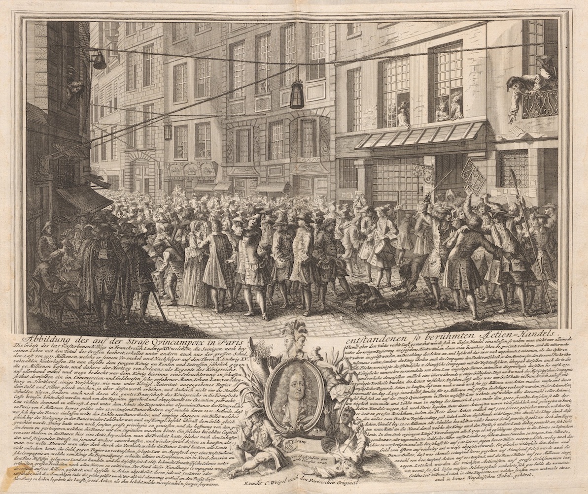

How quickly the association between Law’s person, Law’s Company, and the wilderness of Louisiana turned sour is made evident in a cartouche-like vignette on a German print from 1720 that links a pre-existing image of Company share-trading in Paris’s Rue Quincampoix with a text lambasting Law (Figs. 11a and 11b).[54] This 1720 print was created by Christophe Weigel, the same engraver who recopied the de l’Isle map and added to it the cartouche of two men trading Company shares for gold coins. The iconography that had indicated the bounty of Louisiana in Company literature and in Bodenehr’s and Senex’s maps is here turned on its head, beginning with the repetition of Law’s portrait in miniature. Here, Weigel crowns it with a double-faced female Janus figure—a symbol of Law’s duplicitous economic and geographic mythologies. On the left side of the image, a beautiful woman holds a cornucopia upright filled with jewels and coins: Law’s promises. Below her, not indigo plants but blossoming cattails (cane)—cleared by Indigenous Peoples in the background of the Marquette/Jolliet map cartouche—link her to a despondent, seated man. He is chained in perpetual servitude to the stone supporting Law’s image, his death sentence lying on the earth below him in the form of a paper letter. The paper, which represented his share in the great profits Louisiana’s earth was projected to contain, reveals only the soil’s barrenness. At right, in a strange perversion of Senex’s cherubs, more letters of credit are poured down from a withered, cornucopia-wielding woman atop Law’s portrait. The letters fall upon terrified courtiers, one man already plunging his sword into his body as a result of his newfound poverty. Instead of making one rich, the land which engendered this death scene offers no future. In failure, as in success, the mythology that money could be made quickly and easily by investing in Law’s Company, or by settling in Louisiana, was painted with the same brush.
Economic, social, and political developments in the colony after Law’s downfall in 1720 caused Louisiana’s abundance to be increasingly re-visualized as a dangerous excess of unpredictable wildness: untamable without slave labor, inhospitable, and inexorably violent. The environment was hostile; the first major hurricane to hit the new town of New Orleans in 1723 nearly wiped it out completely.[55] A significant workforce was required to profitably cultivate cash crops; though the first slave ships arrived at Louisiana’s shores only shortly before Law’s downfall, the 1720s saw an intense acceleration in the importation of enslaved Africans, commensurate with the labor required for the increased attempts at large-scale farming.[56] Small-scale agricultural farming—and the attendant dream of freedom from serfdom for white Frenchmen articulated in Law’s publicity tracts—was increasingly abandoned as a profit-generating ideal in favor of plantation-style cultivation of indigo, rice, and tobacco.[57] Louisiana was moving, albeit haltingly, towards an Antilles-style social and political colonial regime. The Code Noir, which had regulated slave behavior and dictated master-slave relations in the French Antilles, was adopted in Louisiana in 1724.[58] By the end of the 1720s, the colony had developed a plantation-based economy more along the lines of what Crozat and Law had envisioned in private mémoires on the subject but had never really bothered to develop on the ground.[59]
The brutal, bloody wars with the Natchez tribe in the late 1720s, instigated by a French attempt to appropriate their sacred lands for large-scale tobacco and indigo cultivation, cemented the reputation of Louisiana within France as an unstable place of unpredictable extremes.[60] The Natchez Massacre and the French retaliation decimated the local population and nascent cash- crop plantations in the area. Law’s Company of the West, despite having merged with the Company of the Indies in 1719, could no longer sustain the heavy losses Louisiana had been accruing since 1717; accordingly, the Company of the Indies was reorganized in 1731 to exclude trade with Louisiana.[61] Law’s gamble on the colony’s profitability had become disastrously unsalvageable.
Shortly after the Company’s reorganization and more than a decade after the Mississippi Bubble had burst, the inextricable link between the failures of Law’s System and those of the colony itself resurfaced in Matthäeus Seutter’s Map of Western America of 1734. Louisiana was here depicted as a source of (French) economic ruination (Fig. 12a). Seutter’s divisions of North America’s terrain placed French Louisiana farther away from traditional sources of bounty, as the cartographer redressed some of de l’Isle’s excesses by returning most of the Carolinas to Britain and the southern Rocky Mountains to Spain. In an even more aggressive illumination of the dead-end that mining in Louisiana had reached, Seutter rid the immediate terrain around the Mississippi River Valley of its mountainous iconography.
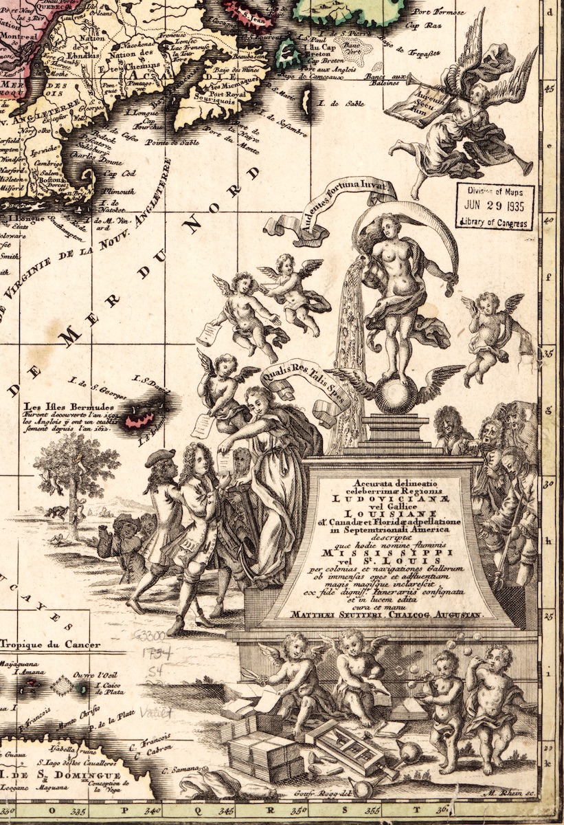
Around one-sixth of the map is given over, however, to the intricate cartouche criticizing Law’s System (Fig. 12b). Seutter, a German cartographer, would certainly have been familiar with contemporary engravings relating to the Mississippi and South Sea Bubbles of 1720. His cartouche draws extensively on the visual language of bubble iconography, found in Weigel’s 1720 print and concretized in the Dutch satirical image and text compendium, Het groote Tafereel der dwaasheid (The Great Mirror of Folly, abridged here as the Tafereel).[62] The compendium, published in 1720, brought together Greco-Roman, biblical, and other allegorical imagery in poems, texts, cards, and maps relating to the speculative bubbles in England, Holland, and France—and contains a much more negative rendition of the print Weigel used in his own satire of Law.[63]
Seutter’s cartouche mobilizes the imagery of abundance built up from the earliest maps of French Louisiana and eviscerated in the prints in the Tafereel. Above the inscription on his cartouche’s plinth is a figure of Fortuna standing on an unstable, winged orb.[64] Here posed like an amalgamation of the River God in Senex’s map, the Mississippi Company crest on de Fer’s map, and the young woman of Weigel’s print cartouche, Fortuna holds a cornucopia from which flows water studded with gold and jewels: the Mississippi itself and the trade it will bring, projected as liquid gold. That hope of great riches, further highlighted by a Latin inscription at Fortuna’s feet (“Qualis Res Talis Spes”), is translated into paper shares wielded by cupids on the left.
On the right of the cartouche, on the side of the Old World, are the men who have already been betrayed by this mirage of gold. Over them a cherub shakes only an empty bag of money. The distressed French noblemen tear their hair (and wigs) off, clasp their hands in anguish, or attempt suicide, either by strangulation or falling on a sword, as one man did in Weigel’s print cartouche of 1720. The iconography of suicide and of men stripping off their courtly apparel is a sign of changing wealth in the Tafereel’s prints.[65] Also typical of Bubble iconography are the insouciant cherubs below the inscribed pedestal, who blow bubbles as they create new shares from paper.[66] The paper shares they cut lie on the earth next to empty sacks of gold, signifying only the illusion of wealth in the face of the actual impoverishment of Louisiana’s land.
Louisiana’s elusive prosperity is both propagated and undercut by the activity at the left of the cartouche, where Company shares are handed out by cherubs and a goddess who has her hand on an anchor. This figure often personifies Marine activity, which here could be the navy, bringing colonists or concessionaires, possibly even the men on the left, to Louisiana. The well-dressed men in the left foreground accept the paper shares gratefully. Behind them, set into a landscape of rolling hills, two more men converse, pointing at the land (and map) even further in the background. One makes a gesture similar to that in the 1718 Weigel map cartouche, equating his bag of gold with Louisiana’s terrain. Behind him rise the craggy mountains articulated in the cartouches of the earliest French maps of the colony: still mythical, still promising gold.
A tree towards which the gold-wielding man also gestures stands between him and the mountains. Its leaves resemble contemporary depictions of the dense foliage of mulberry trees—native to Louisiana and the source of fantasies of silk cultivation in Law’s publicity tracts.[67] The tree is climbed by what looks to be the same man, shown in a compressed unit of time: ascending the tree and then falling down from its great height. The imagery of individuals climbing a tree was famously mobilized on a print of a “Bubble Card” made to satirize the South Sea Bubble in Britain.[68] However, the British bubble tree is climbed by noble men and women alike; attracted to its fruit-laden boughs, they ultimately fall, victims to its treacherous surrounding waters. In the Seutter map, the tree is barren, like the hard ground beneath it on which the falling man breaks his back. The emotions in the man’s body language convey less an attraction to climbing than the fear of falling and the fall itself. Falling to one’s death is a common fate of many investors in Tafereel imagery: shareholders and allegories of Companies are seen plummeting earthwards from cliffs and buildings to which Law, or Fortune, has led them. [69]
But the grand master of the great fall remains Law himself. In the Tafereel, Law, with his development of the Mississippi System, is likened to Icarus, a figure of Greek myth who climbed to great heights on artificial wings, only to fly too close to the sun and finally fall to the ground, dead (Fig. 13).[70] The gold allegedly located in the distant mountains behind Seutter’s fateful tree is here revealed as a costly illusion before the investors or settlers can even begin to reach it. There are no riches without labor, and there would be no source of ready labor in Louisiana without colonial violence.
Conclusion
The texts, images, and maps produced in 1717-1720 in response to Law’s effort to publicize Louisiana as a profitable enterprise effectively captured investors and settlers’ imaginations by using and further developing the geographic speculation present in the earliest maps and travel narratives of the Mississippi River. Colonization and speculation, both geographical and pecuniary, under Law became an exercise in exchanging the known for the unknown in the hopes of obtaining a profit of mythic proportions. The very principle of Company shares ultimately conditioned the French colonial dream of an almost farcically fertile promised land in America.
Law’s person and persona, as the reprinting of his unaltered portrait (Fig. 1) in most editions of the Tafereel suggests, were key elements marshaled in support of that dream.[71] His portrait’s implausible background almost gives the game away, except that the product he is selling in this image—the labor-free lifestyle of wealth accumulation (his opulent clothing), surrounded by both luxurious comfort (his magically manicured garden) and exoticized danger (the distant mountains)—is of universal appeal, as indeed was that of his Louisiana. In its deliberate obscuring of the labor required to generate wealth, the portrait echoes the “cartographic silences” in the maps of Louisiana from 1717 onwards. The silent labor of the French gardeners, weavers, and lace-makers needed to create Law’s projected look of confidence is concealed here, just as maps of Louisiana suppressed Indigenous knowledge, colonial imperatives of forced labor, and violence against Indigenous Peoples. The leap of faith required in both geographic and economic speculation is doubtless more easily performed when such elements are hidden in plain sight, tied instead to a flesh-and-blood embodiment of Icarus, ascending.
Camille Mathieu is a Lecturer in Art History and Visual Culture at the University of Exeter, UK
Acknowledgments: For their support and research assistance, the author would like to thank the AHRC, Liz Chant (UCL) and, at the Library of Congress, Washington DC: the Kluge Center, Julianna Meinz, and all the staff of the Geography and Map Division—especially Mike Klein, Ed Redmond, and Tony Mullan. The author would also like to thank the editors and anonymous reviewers of this volume of Journal18 for their comments on earlier drafts of this work.
[1] The Company of the West (Compagnie de l’Occident) is the official, royally mandated name of the commercial enterprise founded by Law in 1717 to exploit Louisiana (see Lettres patentes En Forme d’edit, Portant Establissement D’une Compagnie De Commerce: Sous Le Nom De Compagnie d’Occident (Paris: Imprimerie royale, 1717), Article 1, 4. As such, this is the Company that will be referenced in this text. It is commonly referred to as the Mississippi Company in both 18th-Century and modern imagery and scholarship. In 1719, the Company of the West merged with the French East India and China Companies to become the (French) Company of the Indies (Compagnie des Indes). See Albert Girard, “La réorganisation de la Compagnie des Indes (1719-1723), Part 1,” Revue d’histoire moderne et contemporaine 11:1 (October 1908), 15, 20.
[2] Recently, Paul W. Mapp, The Elusive West and the Contest for Empire, 1713-1763 (Chapel Hill: The University of North Carolina Press, 2013). See also Arnaud Orain, La Politique du Merveilleux (Paris: Fayard, 2018).
[3]“Cartouches,” Imago Mundi 27 (1975), 8. Also J.B. Hartley, “Deconstructing the Map,” Cartographica 26: 2 (1989), 1-20.
[4] C.N.G. Clarke, “Taking Possession: The Cartouche as Cultural Text in Eighteenth Century American Maps,” Word and Image 4:2 (1988), 455-456.
[5] See J. B. Hartley, “Silences and Secrecy: The Hidden Agenda of Cartography in Early Modern Europe,” Imago Mundi 40 (1988): 57-76.
[6] On the economic relationship between Company shares and Louisiana, see chapters 12-15 in Antoin E. Murphy, John Law: Economic Theorist and Policy-maker (Oxford: Oxford University Press, 1997).
[7] Murphy 1997, “The Conceptualization of the System,” 2.
[8] “Indigenous Peoples” will be used throughout this text to refer to Native American Indians or First Nations Peoples, as per Michael Yellow Bird, “What We Want to Be Called: Indigenous Peoples’ Perspectives on Racial and Ethnic Identity Labels,” American Indian Quarterly 23:2 (1999), 2.
[9] Mapp, 150-157. Also Carl A. Brasseaux, “The Image of Louisiana and the Failure of Voluntary French Emigration, 1683-1731,” Proceedings of the Meeting of the French Colonial Historical Society 4 (1979), 47-48.
[10] Jean M. O’Brien, Firsting and Lasting: Writing Indians out of Existence in New England (Minneapolis: University of Minnesota Press, 2010). Also Lauren Beck, “Implicating Race in Exploration History,” Terrae Incognitae 50:3 (2018), 96-97.
[11] Alfred E. Lemmon et al., Charting Louisiana: Five Hundred Years of Maps (New Orleans: Historic New Orleans Collection, 2003), 34.
[12] Surekha Davies, Renaissance Ethnography and the Invention of the Human: New Worlds, Maps and Monsters (Cambridge: Cambridge University Press, 2016), 2, 116.
[13] Lettres patentes du Roy qui permet au sieur Crozat, secrétaire du Roy, de faire seul le commerce dans toutes les terres possédées par le Roy et bornées par le Nouveau-Mexique et autres, sous le nom de gouvernement de la Louisiane (Paris: 1712), 2-4. Also Lettres patentes (1717), 6, 11.
[14] Lettres patentes 1712, 4-7.
[15] Lettres Patentes 1717, 4, 17-18.
[16] Orain, La Politique du Merveilleux, 176-186.
[17] These propaganda texts from the Nouveau Mercure were transcribed, annotated, and translated in May Rush Gwin Waggoner, ed., Le Plus Beau Païs Du Monde: Completing the Picture of Proprietary Louisiana, 1699-1722 (Lafayette: Center for Louisiana Studies, 2005), 34-101. Hereafter, letters are referred to by original publication date, citing the pages of the English translation. Waggoner, ed., Le Plus Beau Païs Du Monde,“Introduction,” 19-31; February 1718, 49.
[18] Sophie White, “Geographies of Slave Consumption: French Colonial Louisiana and a World of Goods,” Winterthur Portfolio 45:2/3 (2011), 235.
[19] Waggoner, ed., Le Plus Beau Païs Du Monde, September 1717, 37.
[20] Ibid.,September 1717, 45; February 1718, 67, 79; March 1719, 85.
[21] Ibid., September 1717, 43; February 1718, 59; March 1719, 85. A color image of this print can be found here: http://hnoc.minisisinc.com/thnoc/catalog/1/2813 (accessed September 15, 2020).
[22] Ibid.,March 1719, 85.
[23] Orain notes that the provision of slave labor by “nègres” for both mining and cultivation is written into what he believes to be the preparatory text from which all the Nouveau Mercure articles were drawn: the anonymous Mémoire sur la Compagnie du Mississipi et les établissements qu’elle se propose de fonder en Louisiane, Archives Nationales d’Outre-Mer,C13 A5 f.13 (Orain, La Politique du Merveilleux, 181-183). However, there is no evidence that this preparatory text was ever published. Ultimately, the essays printed in the Nouveau Mercure avoid—I argue, deliberately—any mention of African slaves being brought over to do the hard labor of plantation agriculture.
[24] Waggoner, ed., Le Plus Beau Païs Du Monde,September 1717, 43; February 1718, 77.
[25] Ibid., February 1718, 67.
[26] Ibid.,February 1718, 59, 75-77; March 1719, 83-85. See also Daniel Usner, Indians, Settlers, and Slaves in a Frontier Exchange Economy: The Lower Mississippi Valley Before 1783 (University of North Carolina Press, 1992), 244-275.
[27] Ibid.,March 1719, 83-85.
[28] Ibid., March 1719, 85
[29] Ibid.,March 1719, 85. See also Orain, La Politique du Merveilleux, 191-192.
[30] Key maps omitted here but analyzed in my next project include: Nicolas de Fer, La France Occidentale dans l’Amerique Septentrional (1718);and Herman Moll, A New Map of the North Parts of America Claimed by France (1720).
[31] This map’s dating is problematic; it was reprinted in multiple languages and contains geographical information outdated by 1718, but reproduces a later version of the Company seal, also in use on Moll’s 1720 map.
[32] Law’s dress here is similar to that of the “Actioniste” character in the Tafereel who proffers shares to prospective buyers, e.g., ‘Quinquenpoix’ pl. 75. See also Nina L. Dubin, Meredith Martin, and Madeleine C. Viljoen, Meltdown! Picturing the World’s First Bubble Economy (Turnhout, Belgium: Harvey Miller/Brepols, 2020), 104-109. The author would like to thank Nina Dubin and Meredith Martin for allowing her advance access to this publication.
[33] “Illum Admirantur et Omnes Circumstant.”
[34] Michael J. Schreffler, “Vespucci Rediscovers America: The Pictorial Rhetoric of Cannibalism in Early Modern Culture,” Art History 28:3(June 2005): 298-299, 304-306.
[35] Davies, Renaissance Ethnography and the Invention of the Human, 276-271.
[36] Michael Wintroub,“Civilizing the Savage and Making a King: The Royal Entry Festival of Henri II (Rouen, 1550),” The Sixteenth Century Journal 29: 2 (Summer 1998), 465–494.
[37] For the longevity of Tupinamba iconography, see Dubin et al., Meltdown, 63-65.
[38] Waggoner, ed., Le Plus Beau Païs Du Monde, February 1718, 49.
[39] Orain, La Politique du Merveilleux, 82-88,176.
[40] Lemmon et al., Charting Louisiana, 58. See also N-M. Dawson, L’Atelier Delisle. L ‘Amérique du Nord sur la table à dessin (Sillery, Québec: Septentrion, 2000), 239-241.
[41] On Weigel’s map, see Orain, La Politique du Merveilleux, 179-181.
[42] On de Fer’s 1718 map, see Ibid., 179.
[43] Lemmon et al., Charting Louisiana, 58; Orain, La Politique du Merveilleux, 177-181.
[44] Spanish conquistador Hernando de Soto’s explorations (1539-1542) are also demarcated.
[45] Waggoner, ed., Le Plus Beau Païs Du Monde, September 1717, 39-41; February 1718, 57-73.
[46] On examining maps of discovery through a Foucauldian lens, see Hartley, “Silences and Secrecy,” 57.
[47] Orain, La Politique du Merveilleux, 183.
[48] Clarke, “Taking Possession,” 486.
[49] Matthew H. Edney and Mary Sponberg Pedley, eds., The History of Cartography, Volume 4: Cartography in the European Enlightenment (Chicago: University of Chicago Press, 2020), 246-247.
[50] Neoclassical architectural features are common decorative elements of cartouches in this period. See Martin Rückner, The Social Life of Maps in America, 1750-1860 (Chapel Hill: University of North Carolina Press, 2017), 218.
[51] Label text from Erin Greenwald, ed., Pipe Dreams: Louisiana under the French Company of the Indies, 1717-1731, exhib.cat. (New Orleans, The Historic New Orleans Collection, 2013).
[52] Lettres patentes (1717), 18. See also Sara E. Melzer, Colonizer or Colonized: The Hidden Stories of Early Modern French Culture (State College, PA: University of Pennsylvania Press, 2012), 91-122.
[53] On the contemporary iconography of Fame, see Dubin et al., Meltdown, 82-85.
[54] The image and text resemble “Rue Quinquempoix en l’Année 1720” in Het groote tafereel der dwaasheid … (Amsterdam: s.n., 1720), pl. 16; however, Weigel leaves the Parisian (Humblot) print unaltered and uses a different “cartouche.” More research must be undertaken to determine whether the German print is derived from the Dutch or vice-versa.
[55] Eleonora Rohland, “Hurricanes in New Orleans: Disaster Migration and Adaptation, 1718–1794,” in Bernd Sommer, ed., Cultural Dynamics of Climate Change and the Environment In Northern America (Leiden: Brill, 2015), 138-139.
[56]Gwendolyn Midlo Hall, Africans in Colonial Louisiana: The Development of Afro-Creole Culture in the Eighteenth Century (Baton Rouge: Louisiana State University Press, 1992), 58.
[57] Waggoner, ed., Le Plus Beau Païs Du Monde, March 1719, 83-87; and “Memoire of Jean Béranger,” 187-189. See also James Pritchard, In Search of Empire: The French in the Americas, 1670–1730 (Cambridge: Cambridge University Press, 2004), 138-139; and Jack D. L. Holmes, “Indigo in Colonial Louisiana and the Floridas,” Louisiana History: The Journal of the Louisiana Historical Association 8:4 (1967), 331-333.
[58] Shannon Lee Dawdy, Building the Devil’s Empire: French Colonial New Orleans (Chicago: University of Chicago Press, 2008), 197-200.
[59] John Law, Œuvres de J. Law … contrôleur-général des finances de France, sous le régent ; contenant les principes sur le numéraire, le commerce, le crédit et les banques: avec des notes (Paris: Chez Buisson, 1790), 409. Christopher Morris, “Wetland Colonies: Louisiana, Guangzhou, Pondicherry, and Senegal” in Christina Folke Ax et al., eds., Cultivating the Colonies: Colonial States and Their Environmental Legacies (Athens: Ohio University Press, 2011), 135-136, 147.
[60] Pritchard, In Search of Empire, 139.
[61] Marcel Giraud, History of French Louisiana, vol. 5, The Company of the Indies, 1723–1731 (Baton Rouge: Louisiana State University Press, 1974), 398; Usner, Indians, Settlers, and Slaves, 72.
[62] For Bubble iconography, see Dubin et al., Meltdown, especially pp. 50-109.
[63] Frans DeBruyn, “Het groote tafereel der dwaasheid and the Speculative Bubble of 1720: A Bibliographical Enigma and an Economic Force,” Eighteenth-Century Life 24:1 (2000), 62-64. See also William N. Goetzmann, Catherine Labio, K. Geert Rouwenhorst, and Timothy G. Young, eds., The Great Mirror of Folly: Finance, Culture, and the Crash of 1720 (New Haven: Yale University Press, 2013).
[64] On the contemporary iconography of Fortune, see Dubin et al., Meltdown, 90-94.
[65] For example, in “Rue Quinquempoix en l’Année 1720,” pl. 16, and “Schyn Bedriegt,” pl. 28.
[66] Dubin et al., Meltdown, 13.
[67] Waggoner, ed., Le Plus Beau Païs Du Monde, September 1717, 37; February 1718, 75-77.
[68] Dubin et. al, Meltdown, 44-47.
[69] See “De Begeerlykheyt Zoekt,” pl. 56; “De Verwarde Actionsten Torenbouw Tot Babel,” pl. 31; and “De Eklips der Zuider Zon,” pl. 15 in Het groote tafereel der dwaasheid, 1720.
[70] See de Bruyn, “Reading Het groote tafereel,” 13; 38, n. 23. See also Dubin et al., Meltdown, 96-102.
[71] Het groote tafereel der dwaasheid, pl. 2.
Cite this article as: Camille Mathieu, “An Effortless Empire: John Law and the Imagery of French Louisiana, 1683-1735,” Journal18 Issue 10 1720 (Fall 2020), https://www.journal18.org/5285.
Licence: CC BY-NC
Journal18 is published under a Creative Commons CC BY-NC International 4.0 license. Use of any content published in Journal18 must be for non-commercial purposes and appropriate credit must be given to the author of the content. Details for appropriate citation appear above.