Jason Nguyen
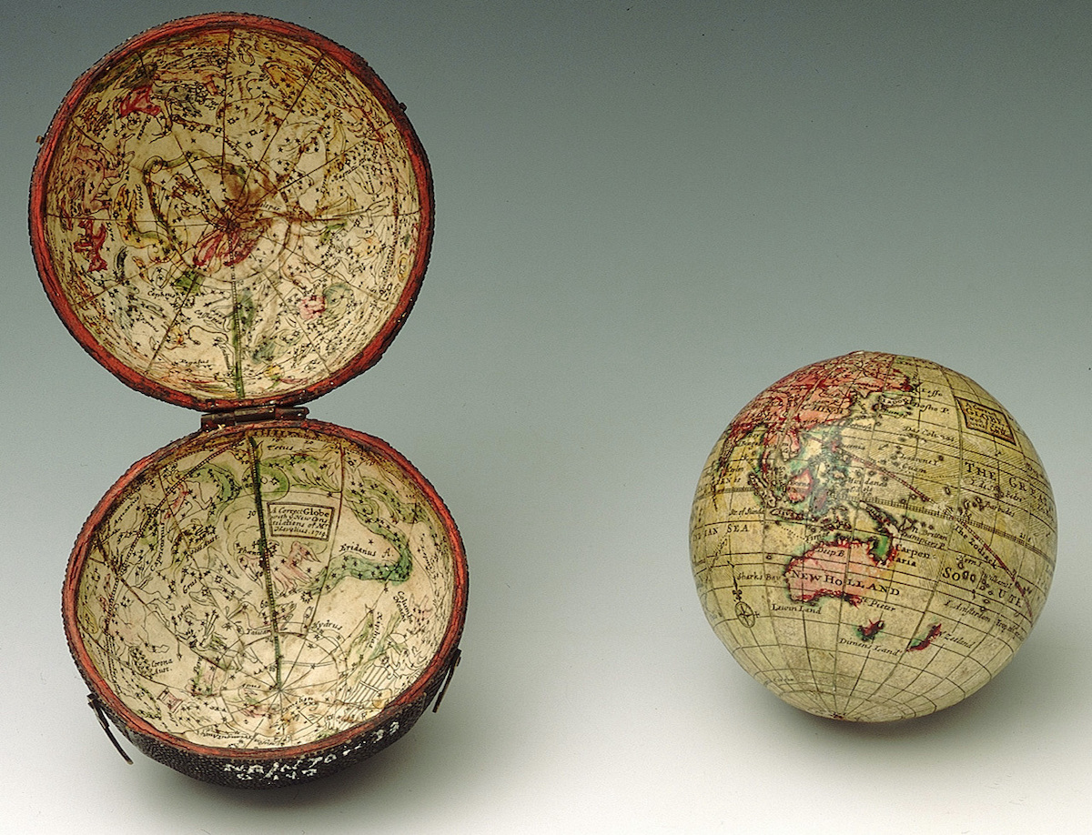
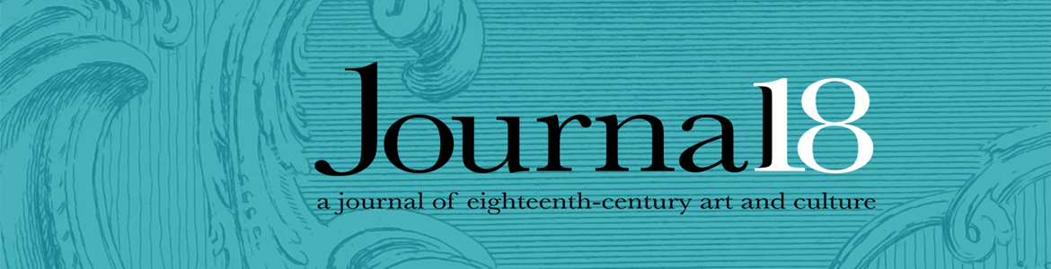
The National Maritime Museum in London houses thousands of artifacts from British nautical history. Among these items is a small handheld globe from 1719 by the British cartographer Herman Moll (Fig. 1). These popular commodities, made of papier-mâché and plaster and wrapped in printed and hand-colored paper, functioned in the eighteenth century as status symbols for prosperous individuals and as educational tools for their children.[1] In this example, geographic regions are toned in reds and greens, with areas unknown to European eyes often illustrated incorrectly, if at all. California is depicted as an island, and northwestern Canada tapers away at around 49° North, after which Moll wrote, “Parts Unknown” (Fig. 2). Between the Tropics of Cancer and Capricorn, small hatch marks depict the direction of the trade winds—the prevailing equatorial easterlies that facilitated early modern sea travel to the Americas. A dashed red line charts the maritime journeys by the English buccaneer William Dampier, which are labeled “Cap.! Damp(ier) tract round ye world.” The three-inch sphere fits within a hinged wooden case, whose interior maps the constellations by the Polish astronomer Johannes Hevelius. This exquisitely crafted object testifies to the artistry involved in globe production as well as the commercial status of cartography in early eighteenth-century Britain.
Moll manufactured pocket globes during the 1710s, when these objects were at their most fashionable. Drawing from earlier Dutch and English examples, cartographers like Moll, John Senex, and Richard Cushee produced these items for a growing consumer base fascinated by globalism and cartography, stemming in part from British imperial expansion and the extensive literature on nautical travel and adventure. A foreigner himself, the German-born Moll moved to London in the 1670s, becoming one of the leading cartographers of his day.[2] In addition to pocket globes, he engraved maps for scientific and literary works, including those by Dampier and Daniel Defoe, and produced his own books, periodicals, and prints. In 1701, he wrote and illustrated A System of Geography, which established his position as an author in his own right.[3] In 1718, he began to print The World Described (1718-1763), an atlas of some two-dozen double-folio maps of regions around the globe (Fig. 3).[4] Moll’s prolific output testified to his commercial spirit as well as the market for cartographic goods during the eighteenth century.
At the time, London was a major center of mapmaking, given its standing as an important scientific hub and the capital of a growing empire. There, Moll was a part of an elite intellectual circle that included Dampier and Defoe as well as Jonathan Swift, John Locke, Robert Hooke, the antiquarian William Stuckey, and the privateer Woodes Rogers, among others. They convened at Jonathan’s Coffee House, the famed meeting place on Exchange Alley that was also the site of financial speculation and stockbroking for the city’s moneyed investors. From his interlocutors, Moll gained prized information about natural history, navigation, and colonial trade, which he incorporated into his cartographic goods. Given that a pocket globe sold for an average of 15 shillings, or about half a month’s wages for a general laborer, one can assume that he intended them for a comfortable if not elite clientele.[5] For a prosperous subset of society, these luxury objects miniaturized a world that was becoming increasingly interconnected through exploration, trade, and the stock exchange. Dampier’s route, boldly delineated across the oceans, gestured to the vast maritime networks that supported commercial prosperity at home.
Moll’s globes and maps frequently included mistakes—a fact that period commentators and contemporary scholars have acknowledged.[6] Swift ridiculed Moll’s errors at the end of Gulliver’s Travels (1726), his fantastical satire of a voyager thrown dramatically off course: “I arrived in seven hours to the south-east point of New Holland” (the period term for Australia), confessed the wayward protagonist.
This confirmed me in the opinion I have long entertained, that the maps and charts place this country at least three degrees more to the east than it really is; which I thought I communicated many years ago to my worthy friend, Mr. Herman Moll, and gave him my reasons for it, although he has rather chosen to follow other authors.[7]
Historians have typically considered Moll’s influence in the context of British imperialism as opposed to cartographic science. Dennis Reinhartz has studied the cartographer in relationship to his social circle, highlighting how Moll’s proximity to Dampier, Rogers, and others provided him with recent geographic and navigational information.[8] His maps, according to Reinhartz, served as crucibles of period intellectual thought. Drawing from methods in book history, Jonathan E. Crowley shows how the organization of The World Described provided an enduring cartographic image of the British Empire to Moll’s readership.[9] The atlas departed from the convention established by Abraham Ortelius’s Theatrum Orbin Terrarum (1570), which opened with an image of the world and then proceeded through the continents. Instead, Moll instructed his readers to begin with the British Isles, then continue to the state’s overseas interests, and end with other global empires. Despite his Eurocentrism, Moll avoided many of the Orientalizing visual trappings of other early modern cartographers.[10] In this regard, his focus was more overly commercial, promoting the economic potential of British colonization and trade. On the domestic front, Philip Koyoumjian explains Moll’s success in the London map trade, showing how the state’s inability to fund expensive cartographic projects left a void that Moll’s studio filled.[11] His lucrative enterprise, which sold individual maps for as low as fivepence each, circulated images of the world to a broad subset of early eighteenth-century British society.[12]
Whereas most scholars have analyzed Moll’s maps, far fewer have studied his globes—likely a result of their brief period of manufacturing and novelty status. Indeed, their smallness and often imprecise assembly precluded their use for navigation or scholarly analysis. Yet, as commodities, they serve as particularly useful case studies for tying eighteenth-century British consumerism to certain geopolitical developments that historians have seen as prescient of global modernity, namely speculative capitalism. This article looks at Moll’s brief pocket globe production during the 1710s and argues that the objects’ design and size, especially when considered alongside his contemporaneous books and maps, signaled changes in both consumer behavior and political economy. In this regard, their diminutiveness reveals and conceals important and often disturbing aspects of modern capitalism as formalized at the time.
Moll produced the small luxury items during one of the most turbulent decades in European political and economic history. Burdened by deficits stemming from the Great Northern War (1700-1721) and the War of Spanish Succession (1701-1714), Britain sponsored the creation of the South Sea Company in 1711. The joint-stock corporation assumed the national debt, for which the government agreed to make payments with an interest rate of five percent. In return, Parliament granted the company a monopoly on the trade of enslaved Africans to the Spanish Americas. Upon the encouragement of Swift, Defoe, and Moll, among others, well-heeled investors at Jonathan’s purchased South Sea shares, hoping to profit from accrued interest on the government’s loan and the company’s overseas activities. During this period, Moll grew his cartographic practice, selling pocket globes, publishing The World Described, and writing two books to promote the South Sea Company (replete with fold-out maps of South America). These events, which coincided with the rise in consumerism in London, generated an unprecedented bubble that famously burst in the autumn of 1720, unleashing a torrent of satirical imagery that ridiculed geography, globalism, and Europe’s frenzied embrace of speculative investment.
The cost of an average pocket globe placed it out of reach for the everyday laborer but within the budgets of London’s emergent middling classes. During the late seventeenth and eighteenth centuries, England witnessed extraordinary growth in luxury consumption by individuals from different social and economic backgrounds. The amount and variety of goods found in the average home increased dramatically, specifically in the case of small decorative objects.[13] The composition and compactness of Moll’s pocket globes speak to the profound transformations in global finance and domestic consumerism at the turn of the eighteenth century. As miniaturizations of the world, replete with Dampier’s nautical journeys, they depicted the maritime infrastructure that generated European wealth. At the same time, their size presumed a portability and conspicuousness that catered to a population fascinated by the novelty of small decorative commodities. As such, they are unique lenses through which to examine the relationship between cartography, consumerism, and the burgeoning structures of global capitalism—along with their attendant connections to colonialism, the stock exchange, and slavery.
Cartography and the Consumer Revolution
The appeal of pocket globes reflects the broadening of Britain’s consumer base as well as the commercial status of geography in early eighteenth-century London. Whereas mapmakers in France worked mostly in the service of the state, those in England aligned more with engravers and catered to a popular clientele. The printmaker Joseph Moxon introduced the novelties to the London market in the 1670s. In a sales catalogue, he emphasized their mobility: “Concave hemispheres of the starry orb, which serves for a case to the terrestrial globe of 3” diameter made portable for the pocket.”[14] Commodities such as these elicited curiosity among eighteenth-century Britons, notably for their artistic inventiveness, references to faraway lands, and reliance on the modern sciences.[15] In his practice, Moll capitalized on two centuries of cartographic practice linked to global travel and colonization. Early modern exploration established a worldwide network of trade, which provided European mapmakers with information about places previously unknown. Britain’s imperial expansion and the consolidation of England, Scotland, and Ireland following the Civil Wars (1636-1651), writes David Armitage, helped establish a collective understanding of empire tied to Protestantism, naval prowess, and commerce.[16] Moll’s pocket globes gave domestic and consumer form to these operations, thereby integrating geopolitics into the private lives and social behavior of his consumers.
The technical demands of navigation conditioned the design of early modern European globes and maps. The oldest known terrestrial globe, credited to Martin Behaim and Georg Glockendon and dating to 1492, bears a striking resemblance to the hand-drawn map that Christopher Columbus likely referenced to chart his travels across the Atlantic.[17] In the mid-sixteenth century, the Flemish geographer Gerardus Mercator began to incorporate engravings in globe manufacturing. He incised geographic data into gore-shaped copper plates, from which he made prints that could be cut out and assembled to make a sphere. His eponymous technique of cartographic projection, which flattened converging lines of longitude so that they sat parallel on a pictorial plane, was the conceptual unraveling of a printed and assembled globe. Because a map in Mercator Projection showed latitude and longitude as universally perpendicular, mariners could draw a line of constant bearing as straight (on a globe, these lines spiral toward the poles). This approach, which exaggerated the geography at the poles (given that due north and south were evenly spread across the map’s top and bottom), distorted spatial reality for the purpose of navigation.
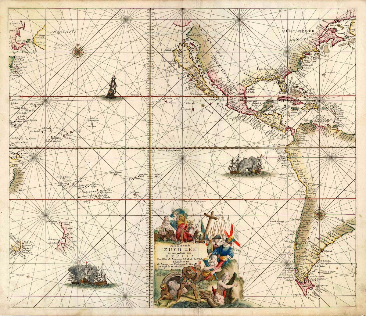
In addition to their functionality, maps and globes promoted European colonization. A chart of the South Seas from Johannes van Keulen’s popular Nieuwe Lichtende Zee-Fakkel (1681-1684) illustrates Dutch ships overpowering their Spanish adversaries (Fig. 4).[18] The cartouche at the bottom celebrates the political union of the Dutch and English, brought into accord by the marriage of William and Mary. In 1677, William, the Prince of Orange and Stadtholder in the Dutch Republic, married his cousin Mary II, third in line to the English throne, in a gesture to unite the countries following the Anglo-Dutch Wars (1652-1654, 1665-1667, and 1672-1674). The alliance of the two naval powers established a consolidated Protestant front against France and Spain. During the early modern period, clergymen like Richard Hakluyt and philosophers like Hugo Grotius encouraged overseas expansion in the name of the reformed faith.[19] The connection between religion and colonialism is made evident by the image above the map’s title. There, van Keulen delineated how commerce (illustrated by the allegorical woman with a ship atop her head), buttressed by geography (the globe), military valor (the figure of victory), and the reformed faith (the naked cross), would bring enlightenment to the violent people of the South Seas (the man to the left is shown carrying a sack of decapitated heads). The Orientalizing depiction of the Pacific Islander contrasts with the purified image of Protestant virtue. The map suggested that access to the world’s bounty was the Protestants’ God-given reward for a life founded on reason and intellectual clarity—conditions that were refined through sea travel and trade.
Moll’s collaboration with established navigators contributed to his commercial popularity. He worked for the London publisher James Knapton, who printed several books on overseas travel and trade, giving Moll unparalleled access to information on maritime geography. By the late seventeenth century, most European writers had abandoned their reliance on classical and biblical texts to explain foreign lands. As such, cartography supported an approach to natural history that privileged empirical observation and description. He engraved the maps for William Dampier’s A New Voyage around the World (1697), which chronicled the latter’s nautical journeys between 1679 and 1691.[20] Moll recycled information from the map for later endeavors, including The World Described and his pocket globes from the 1710s, despite important scientific realizations—notably, the fact that geographers had since confirmed Baja California’s status as a peninsula and not an island. Dampier’s book caught the attention of the Admiralty, which in 1699 commissioned him to explore the eastern sections of Australia.[21] That year, Knapton published the buccaneer’s A Discourse of Trade-Winds (1699), for which Moll similarly provided the maps.[22]
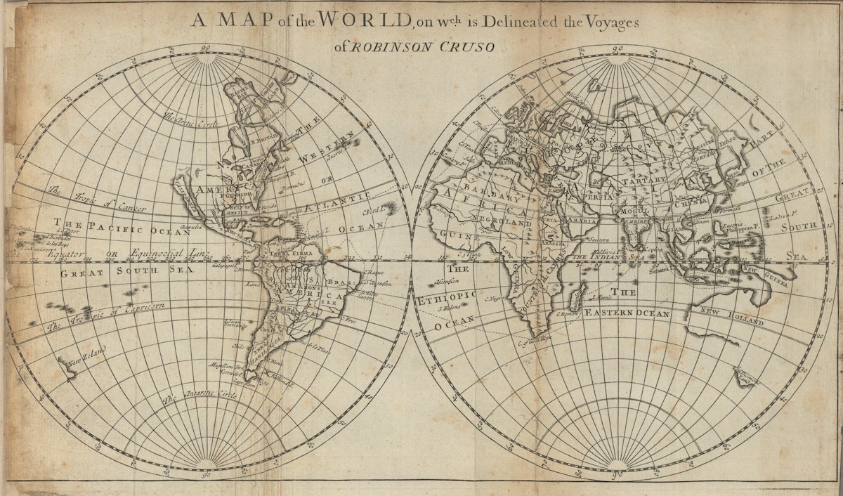
Dampier and Moll mutually benefitted from their partnership. With Moll, the buccaneer gained a well-known illustrator. Moll’s richly detailed maps fed the reader’s imagination by giving visual form to places only known through travelers’ accounts and the growing body of literature on pirates and privateering.[23] From Dampier, the cartographer received the latest geographic information, which he employed in later commercial endeavors. It is not surprising, then, that Daniel Defoe turned to Moll to provide the maps for his Robinson Crusoe series of 1719.[24] At the beginning of The Farther Adventures of Robinson Crusoe, released four months after the initial novel, Moll reproduced Dampier’s map, though replacing the buccaneer’s path with that of Defoe’s seafaring traveler (Fig. 5). Despite the book’s astonishing plot, the Crusoe saga struck many readers as shockingly realistic, notably for the confessional nature of the prose and the rich descriptions of nautical travel and foreign landscapes.[25] The inclusion of cartographic imagery, drawn from books on maritime travel and trade, anchored Defoe’s tale in geographic space and gave credibility to his dramatized account of nautical adventure.[26]
Maps, globes, and atlases were also fashionable teaching devices. The manual from one pocket globe recommended that children suspend it in front of a candle to mimic Earth’s orbit around the sun.[27] Similarly, an eighteenth-century atlas outlined how geography supported the “education of young minds, for young Gentlemen, for the rustic with time for self-education, for the merchant or general trader.” Its proper understanding helped one maintain “useful and polite Conversation, [making one] qualified to confirm, to object, to explain, to correct, or to refute … and thereby keep up that spirit which is the Soul of good company.”[28] Broadening economic opportunities among the commercial population and medical developments that increased the average lifespan led to an approach to education that stressed socialization more than religious salvation.[29]
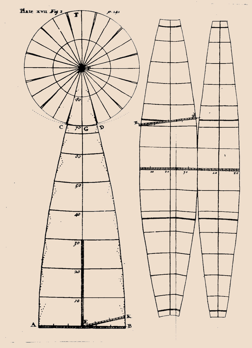
The interest in geography was so widespread that, in 1717, the cartographer John Green published The Construction of Maps and Globes, which included a template to assemble a paper globe oneself (Fig. 6).[30] The circle on the upper left depicts the poles, and the gores on the right illustrate the area between lines of longitude. This fabrication technique is discernible on Moll’s pocket globe, noting the loss of paper at the Arctic Circle (Fig. 2). Green criticized the errors of past cartographers while highlighting geography’s importance for facilitating travel and trade and for eliciting a sense of adventure. Directed at financially comfortable consumers, amateur mapmakers, and would-be voyagers, cartographic manuals and pocket globes helped popularize scientific information that was once reserved for navigators, scholars, and politicians. They aided sociability—long considered a force that contributed to secular modernity—while also embodying the ideology of European imperialism and commercial expansion.
The Geography of Speculation
Cartography helped visualize the overseas activities that supported economic prosperity at home. Defoe, in his Atlas Maritimus & Commercialis (1728), a richly illustrated atlas written for “gentlemen, merchants, and mariners,” categorized geography not as a humanist endeavor but instead as a tool for the promotion of commerce, government, and empire.[31] He conceived the world as a source of natural reserves bound together by shipping and trade. The merchant’s duty was to manage and manipulate this system of commodities in order to maximize national economic growth.[32] To protect its commercial and colonial networks, Britain dramatically increased its military budget, which it leveraged against a series of economic reforms, notably a raise in taxation, the development of credit and public deficit financing, and the creation of institutions to manage monetary operations.[33] From the seventeenth century onward, banks and trading corporations supported the government’s fiscal and military operations through private investment. Moll’s cartographic images fueled the imagination of Britain’s would-be shareholders by illustrating the colonial resources to be extracted and exchanged on the international market.
The Glorious Revolution (1688-1689), which deposed the Catholic James II and VII in favor of his Protestant daughter Mary II and her husband William of Orange, ushered in a wave of political and economic reforms.[34] To fund ongoing involvement in the Nine Years’ War (1688-1697), William and Mary supported the creation of the Bank of England, established in 1694 by the Whig statesman Charles Montagu. Modeled on the Bank of Amsterdam, it granted the state interest-accruing loans to finance the war.[35] Presuming Westminster’s financial stability, private stakeholders purchased bank shares, which supported everyday operations and generated profits for investors based on interest revenue. In its early years, the bank lent an astonishing £45 million to the government, thereby generating an annual return rate of almost twelve percent for its shareholders.[36] The institution, which lacked a permanent headquarters until 1734, operated out of Grocers’ Hall in the City of London, the financial heart of the empire. The trading that ensued prompted Defoe to write sarcastically that the area had morphed into a veritable “Corporation of Usury.”
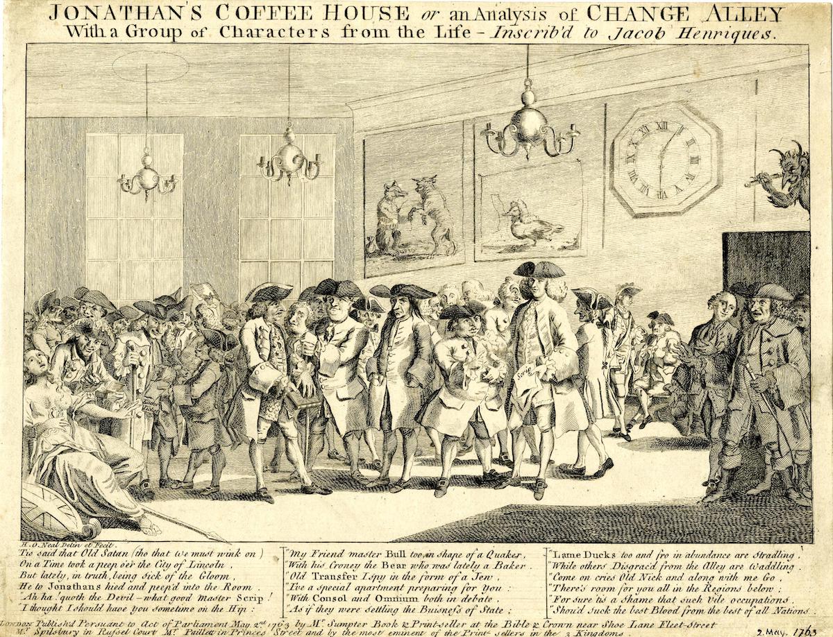
The Bank of England and trading institutions like the East India Company (est. 1600), the Royal Africa Company (est. 1660), and the Hudson Bay Company (est. 1670) fit within a broader European culture of financial speculation. In London, the Royal Exchange provided a venue for the market valuation of stocks and commodities.[37] It established the prices for goods like spices, sugar, and furs and brought different colonial powers and trading enterprises into competition. At coffeehouses like Jonathan’s and Garraway’s, financiers bought and sold shares, which generated a secondary market in Europe that was physically detached from the act of resource exploitation (Fig. 7). To manage the dangers associated with maritime travel, marine insurance companies such as Lloyd’s and the Rotterdam Company in the Dutch Republic placed a premium on the chance that commercial goods might be lost at sea.[38] These efforts, writes the historian Jonathan Levy, marked the beginning of a global risk economy, whereby the chance of peril itself became a commodity.[39] During the seventeenth and eighteenth centuries, stock gambling and insurance—actions that today seem like conceptual opposites—were understood as commercial pairs and supported the emergence of an economy premised on speculative investment in colonial markets.[40]
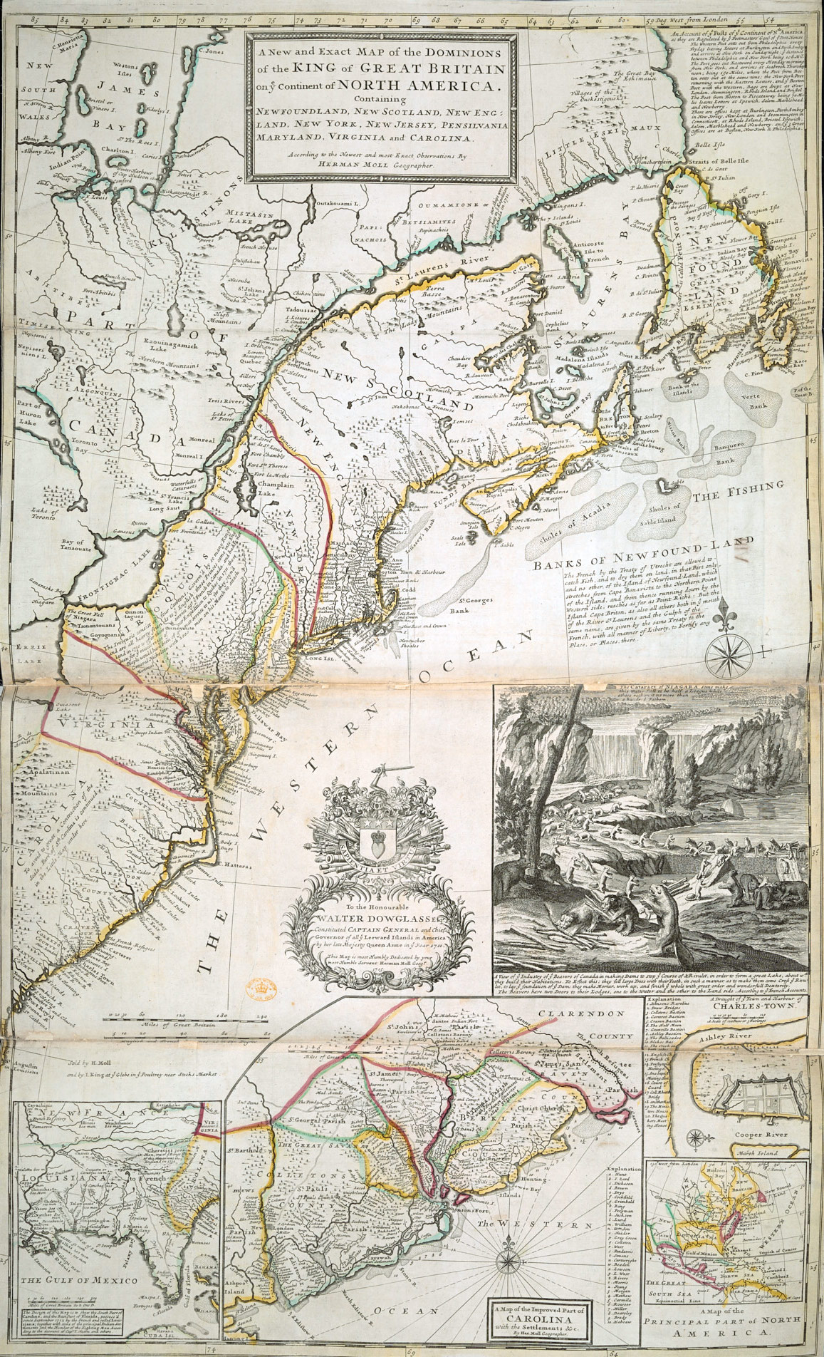
Moll’s maps of North America celebrated the wealth to be gained through resource extraction and trade. His New and Exact Map of the Dominions of North America (1715), commonly known as “The Beaver Map,” visualized the fishing and fur industries and defended Britain’s territorial claims against the French (Fig. 8). He asserted the country’s sovereignty over much of the land from Newfoundland to the Carolinas, writing atop the Grand Banks that the French were permitted “to catch Fish, and to dry them on land, in that Part only, and no other, of the Island of Newfound-Land.”[41] The vignette directly below, which Moll lifted from a print by the French cartographer Nicolas de Fer, showed beavers felling trees and constructing a dam at the base of Niagara Falls.[42] The scene promoted the fur trade, which supplied pelt for the European hat industry, while also stressing the Protestant virtue of labor for colonial settlement and expansion. While Moll acknowledged the Iroquois presence along the shores of Lake Ontario, writing that they were “hearty friends to ye English,” the allegorical inset nevertheless reinforced the perception of the Americas as a place of untapped abundance awaiting European cultivation.
Mapping the South Sea Company
The costs to fund the War of Spanish Succession left Britain on the edge of financial collapse. Government spending averaged £7 million per year, with the public debt standing at an unprecedented £36 million at the war’s end.[43] The conflict, which pitted France and Spain against the Grand Alliance (England, the Dutch Republic, and the Archduchy of Austria), concerned the future of the Spanish crown and, by consequence, the control of its resource-rich American colonies. Should Philip V retain the throne, France and Spain would be ruled under a unified House of Bourbon, thereby extending French influence in the Americas. By 1710, with deficits skyrocketing, investors began to lose confidence in the state’s liquidity, initiating a credit slump that threatened Britain’s ability to sustain battle.[44] The Tory statesman Robert Harley, recently appointed Chancellor of the Exchequer by Queen Anne, sought to restructure government debt.[45] In 1711, he launched the South Sea Company, which absorbed the remainder of the national debt (nearly £9.5 million) in exchange for a monopoly on British trade in the Spanish Americas. Moll, eager to capitalize on early interest among London’s investors, published two books on the economic prospects of the joint-stock venture. Like his pocket globes, the illustrations focused on the maritime infrastructure of trade and exchange. In doing so, he emphasized the idea that domestic prosperity relied as much on speculative investment as on the import and export of commodities in and out of Britain.
Joint-stock corporations like the South Sea Company and France’s Mississippi Company harnessed state budgets to private investment. From the government’s side, these companies assumed debts in exchange for overseas trading privileges. From the investors’ side, shares from a successful company promised extraordinary financial rewards through dividends. To drum up support among potential investors, Harley solicited aid from the influential voices on Exchange Alley.[46] In June 1711, Swift penned an article in the Examiner in which he projected that the Chancellor’s company would “prove the greatest Restoration and Establishment of the Kingdom’s Credit.”[47] Defoe, a frequent confidant and collaborator of Harley, had long advocated for colonial investment in South America.[48] That autumn, he recommended the initiative, writing: “Bringing so great an Undertaking so near Perfection, in so short a time, may well be reckon’d among the Wonders of Her Majesty’s glorious Reign.”[49] Furthermore, a Spanish Empire weakened by a decade of war would be unable to deny British commercial incursions.
Moll’s A View of the Coasts, Countries and Islands within the Limits of the South Sea Company (1711) turned to natural history and cartography to promote the joint-stock corporation. In the Preface, he stressed the importance of the institution for economic prosperity at home: “[T]he Publick Welfare of the Kingdom depends so much on the success of the Company newly Establish’d to carry on a Trade to the South Seas[.]”[50] South America, rich in flora, fauna, and material reserves, was already known to English navigators, notably though the voyages of John Narborough and Dampier. Britain was well positioned to forge trading partnerships with the Hitnu of Arauca (modern-day Colombia) and the Mapuche in Purén (modern-day Chile), among others, who long resented the Spanish presence.[51] That the book concluded with a list of commissioners whom the reader could contact for Company shares highlights the commercial orientation of Moll’s scientific study.
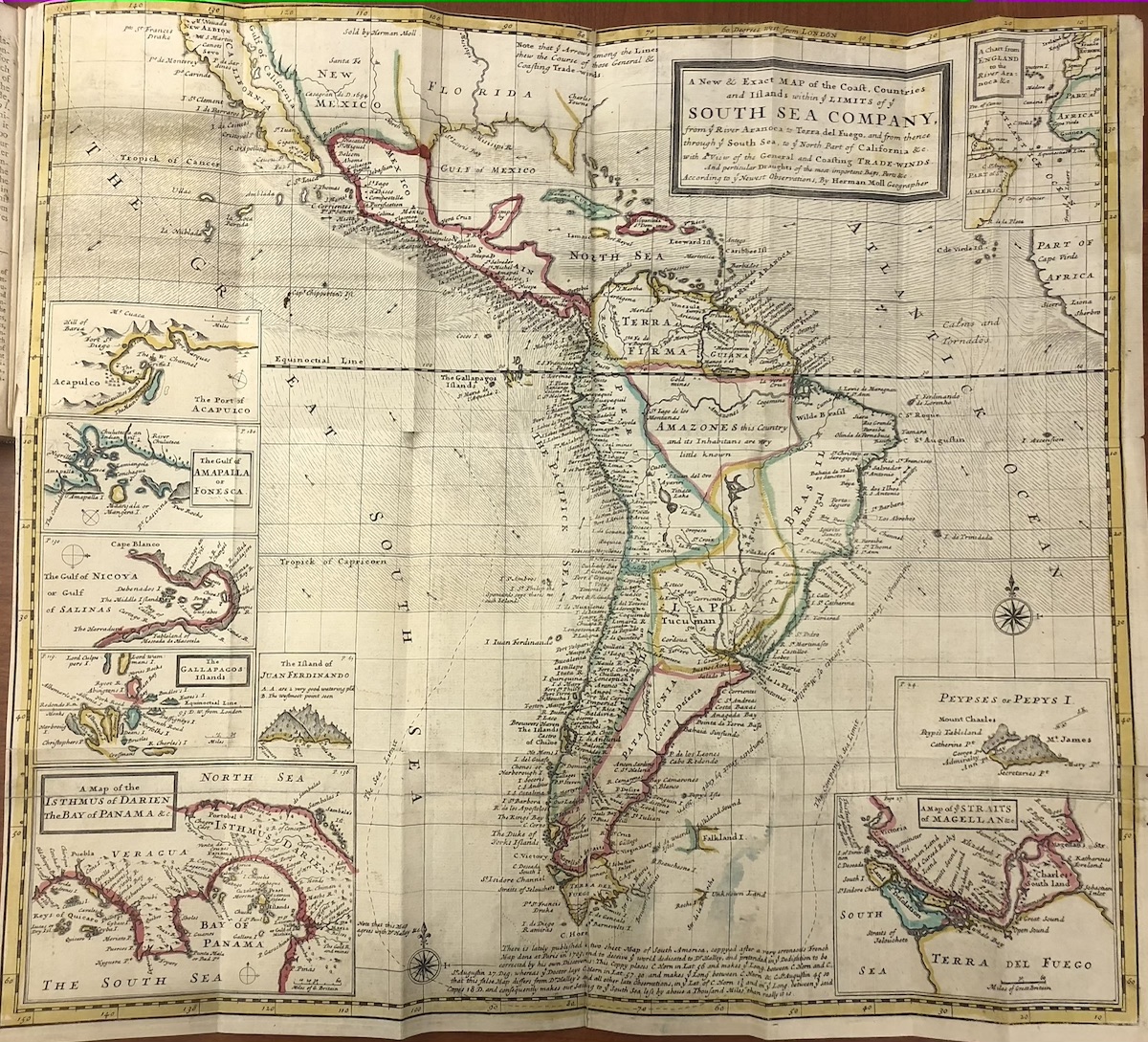
At the end of the book, Moll included a color-coded fold-out map of South America (Fig. 9). He constructed the plan using Mercator Projection, which flattened the cardinal directions and gave the composition the appearance of a nautical chart. The attention to waterways and ports, as evidenced by the sheer number of sites labeled on the shoreline, confirms that Moll’s focus was maritime trade. Nine inset maps ring the edge of the composition, including a distorted one at the upper-right corner of the sheet that charts the journey from England to the Company’s proposed northernmost port at the mouth of the Orinoco River (minimizing the apparent distance between Europe and South America). The others illustrate regional harbors for possible British invasion. Moll demarcated the limits of the corporations’ territorial waters in a dashed line that begins at the Rio de la Plata immediately south of Portuguese Brazil (toned in green), continues around the Terra del Fuego, the island explored by Magellan in the sixteenth century, and extends north along the western coast of the Americas. The book, rich in textual and visual descriptions of the continent and its resources, presented evidence of the Company’s economic potential in an effort to stimulate the curiosity of would-be investors.
In reality, the South Sea Company made few inroads into Spanish trading networks. Instead, it functioned almost entirely as a front for the Atlantic slave trade—a fact understood and accepted by its early backers.[52] The Company’s task, writes the historian Carl Wennerlind, was to assure potential shareholders of the security and profitability of the enterprise.[53] That period debates centered on the risks of nautical travel, as opposed to the life and subjectivity of enslaved Africans, illustrates the degree to which discourses on credit and wealth actively concealed the horrors of forced labor. Moll acknowledged slaving activities by stressing the continent’s port cities and, on the far-right side of the sheet, including the western tip of Africa. Atop the oceans, he denoted the prevailing east-to-west winds that facilitated early modern sea travel to the Americas, which he lifted from Sir Edmund Halley’s recent study of the Earth’s maritime currents and magnetic field. He cited the astronomer by name, thereby placing science in the explicit service of human trafficking.
Cartography and the Slave Trade
Historians have struggled to understand Moll’s involvement in the South Sea Company. There is no evidence that he purchased shares or profited directly from the corporation. Reinhartz positions his interests in South America within the broader European fascination with the South Seas—a concern that, for Moll, dated to his earliest collaborations with Dampier.[54] Gillian Hutchinson more firmly places the book within the context of the transatlantic slave trade.[55] Yet, the singular feature of Moll’s cartographic business was its commercial orientation. It is unlikely to be coincidental that the expansion of his business, which included pocket globes and atlases, intersected with an experiment that promised to expand the city’s consumer base. The design of his novelty globes—which recorded the period’s nautical routes, port cities, trade winds, and the archaic term “Negroland” to denote the African kingdoms from which Britain traded human laborers—nevertheless gestured toward the systems of capital, exploitation, and slavery that fueled British commercial growth.
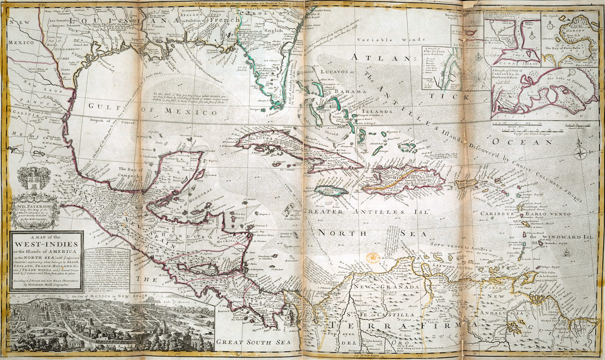
The South Sea Company intensified its engagement with the slave trade following the War of Spanish Succession. As part of the Peace of Utrecht, signed between 1713 and 1715, Spain retained much of its American territories but granted Britain a thirty-year monopoly of the Asiento, the contract that gave exclusive rights to provide enslaved laborers to the Spanish Americas.[56] Queen Anne yielded these privileges to the South Sea Company, with the agreement that it transport 4,800 enslaved Africans per year and share one-quarter of the profits with the Spanish king.[57] Spain allowed the Company to establish offices in the port cities of Buenos Aires, Caracas, Cartagena, Havana, Panama, Portobelo, and Veracruz. At the time, Moll produced a map that highlighted recent British incursions in the Caribbean, specifically the conquests of Barbados in 1627 and Jamaica in 1655 (Fig. 10).[58] The South Sea Company established headquarters on both islands, which Moll toned and labeled “English.” There, attendants received slaving vessels from Africa, as illustrated by the ship sailing toward Barbados on the map. They tabulated the number of enslaved people who survived the Middle Passage.[59] Of those who remained, the healthiest were sent to the designated Spanish ports as part of the Asiento agreement. By color coding the map according to British- and Spanish-controlled territories, Moll granted it a practical function related to the slave trade.
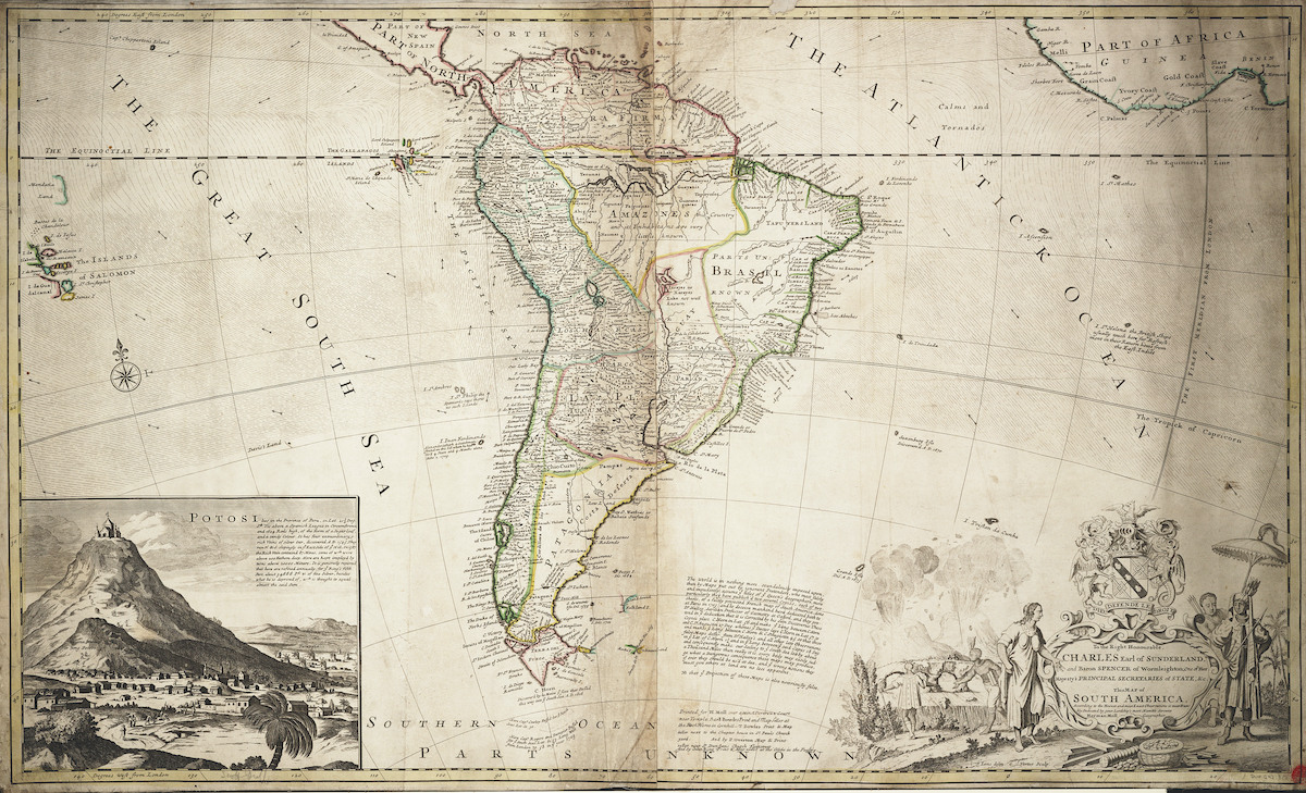
To exploit these new circumstances, Moll issued a second edition of A View of the Coasts, Countries and Islands within the Limits of the South Sea Company. The new map presented a more atmospheric depiction of South America, replacing his buccaneering insets for a perspectival vignette and an elaborately designed cartouche (Fig. 11). The composition functioned as an unequivocal endorsement of Britain’s intercolonial slave trade. On the right of the map, he illustrated western Africa in greater detail. He labeled Sherbro Fort (in modern-day Sierra Leone), Cape Mesurado (in modern-day Liberia), and Elmina Castle, Cape Coast Castle, and Fort Christianborg (in modern-day Ghana), which were ports of departure for European slaving ships destined for the Americas. On the left side of the map, he included a scene depicting the silver mines at Potosi in modern-day Bolivia, where Spanish settlers subjugated 30,000 Africans to drain the mountain of its reserves. In the cartouche at the lower right, the engraver turned to allegory to visualize the commercial relationship between Europe (left) and South America (right). Tellingly, he foregrounded the scene with silver coins and bars, the material resources to be gained by the partnership, and placed the actions of human labor in the background.
Moll’s cartography exists at the intersection of geography and commerce—where the depiction of faraway lands functioned as commodities for a consumer and investor population. As such, Moll’s enterprise sheds light on the political, economic, and geographic infrastructure of speculative capitalism. On his globes, the inclusion of the trade winds and Dampier’s maritime route centered attention on the dehumanized mechanisms of trade and exchange. On the map of the South Sea Company, Moll located the meridian in London, further anchoring the composition in the British Empire’s political and economic center. His use of Global Projection, as opposed to the more utilitarian Mercator Projection of his earlier chart, emptied the map of any perceived navigational function. In this regard, the curving lines of longitude, which granted the image the appearance of a globe, confirmed its status as a commercial as opposed to a practical composition.
Bubbles and Globes
Fervent speculation in the South Sea Company generated unprecedented stock inflation by the early months of 1720.[60] However, the Company made minimal advances in South American trading and consistently failed to fulfill its contractual obligations to the Spanish king. The eventual bursting of the economic bubble unleashed a torrent of satirical images on the commercial print market. Engravers made constant reference to globes, bubbles, and ships in an effort to deride the naïve optimism in overseas speculation.[61] On the fringes of one Dutch print, Minerva, goddess of wisdom, ponders an overturned globe while a ship is violently tossed at sea (Fig. 12). The inclusion of an owl to signify knowledge serves as a rejoinder to the vanity that incited global commercial expansion. In this regard, globes proved no more stable than bubbles, understood both physically and financially. The upturned sphere and the capsizing vessel emphasize the risks of market gambling at home and abroad.
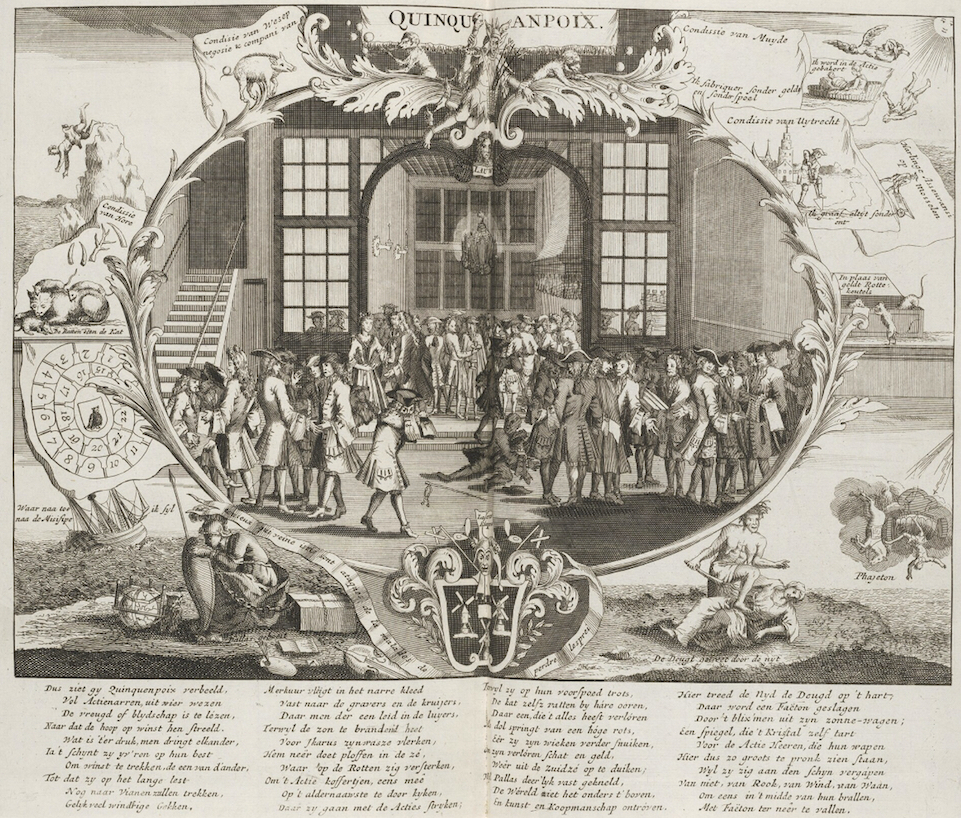
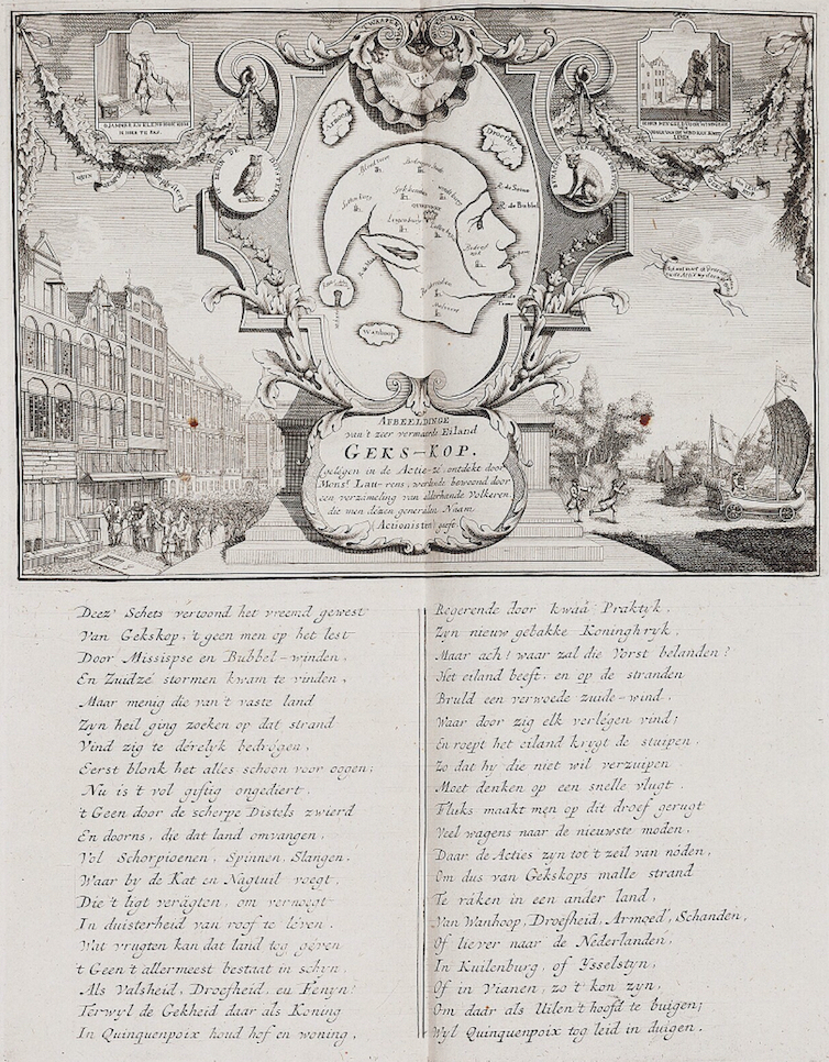
The cartographic depiction of faraway places, which long served to encourage European exploration and settlement, came under critique. That investment in exotic islands proved a fool’s errand was the message of another print (Fig. 13). On the left, a frenzy of investors gambles on potential returns from the Island of Mad-Head, in the center, located in the satirical Sea of Shares. Ports and cities include Deceivers Town, Fool’s Dyke, Foolsbury, Liarbury, Fort Blind, Fort Evil, and the Islands of Poverty, Sadness, and Despair. The three rivers, aptly named the Thames, Seine, and Meuse after the European cities most impacted by the stock market crash, form the profile of a stock trader in a fool’s cap. The image parodied the frontispiece of Sir Thomas More’s Utopia (1516) to ridicule European aspirations and assumptions regarding global expansion. Distant islands were no more suitable for financial investment than they were for idealized colonies or commonwealths.
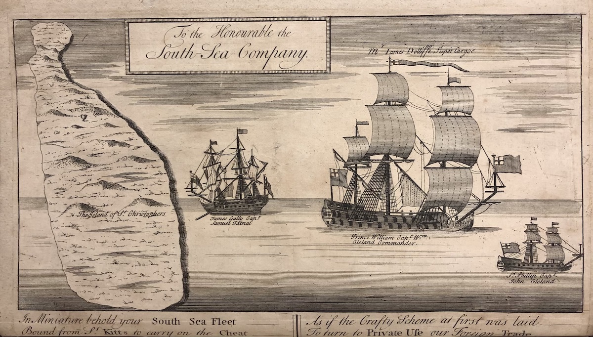
English commentators derided the greed that overtook the City of London. One print turned to rhyme to moralize the South Sea Company’s deception (Fig. 14). “To the Honourable South Sea Company,” mockingly states the print, which portrays three ships in the Caribbean. To the left is the Island of Saint Kitts, over which Britain gained control following the War of Spanish Succession. The plate reads:
In Miniature behold your South Sea Fleet
Bound from St. Kitts to Carry on the Cheat
As if the Crafty Scheme at first was laid
To turn to private use our Foreign Trade.
The words critique the private investor’s attempt at personal gain, especially when anchored in an institution founded on dishonesty. The image sheds light on the horrors of the Company’s trading operations. During the early modern period, Saint Kitts was one of the foremost destinations for slave ships, owing to its status as a plantation island for sugar production. Even after the bursting of the economic bubbles of 1720, the South Sea Company continued its engagement in human trafficking. It is estimated that during the years it held the Asiento, from 1713 to 1739, the Company transported more than 34,000 enslaved people from western Africa to the Americas.
Moll’s cartographic enterprise continued long after 1720. Although he discontinued the manufacture of pocket globes around that year, the objects remained in vogue until the middle of the eighteenth century. Swift, though critical of Moll’s geographic errors, pilfered his maps for Gulliver’s Travels.[62] Defoe’s A New Voyage Round the World (1724), which is widely believed to be a renewed proposal for a South Sea trading scheme, similarly made use of Moll’s books and images.[63] Yet, the cartographer’s publications contained inaccuracies that thwarted the feasibility of the plan, specifically the existence of the Andes where Defoe planned a trading route. It is ironic that Moll’s cartography, which catered to a consumer clientele, undermined the success of a commercial venture. Pocket globes and atlases functioned as goods that, for many eighteenth-century Britons, presented the world as a network of resources by which one could profit through speculative investment. In this regard, the charting of Dampier’s voyage across the surface of Moll’s globe could not innocently suggest the wonder of nautical adventure. Instead, it marked the embrace of an economic system for which domestic prosperity and luxury consumption relied on stock market returns—dependent as they were on imperial expansion and the subjugation of human life.
Jason Nguyen is an Assistant Professor at the John H. Daniels Faculty of Architecture, Landscape, and Design at the University of Toronto in Toronto, Canada
Acknowledgments: I thank Nina Dubin and Meredith Martin for their insight and advice during the writing of this article. The two anonymous reviewers offered invaluable critique. I am also grateful to Michaela Rife, who provided encouragement during critical moments of research.
[1] Katie Taylor, “Pocket-Sized Globes,” in Explore Whipple Collections (Cambridge: Whipple Museum of the History of Science, University of Cambridge, 2009).
[2] Laurence Worms and Ashley Baynton-Williams, British Map Engravers: A Dictionary of Engravers, Lithographers and their Principal Employers to 1850 (London: Rare Book Society, 2011), 456-458; and Dennis Reinhartz, “New Information on Herman Moll, Geographer,” Imago Mundi 40 (1988), 113-114.
[3] Herman Moll, A System of Geography (London: Timothy Childe, 1701).
[4] The World Described appeared in at least ten editions, published in London and Dublin: c. 1718, c. 1720, c. 1726, c. 1728, after September 1730, 1730-1732, 1732-1735, after January 1741, 1740-1745, and c. 1754-1763. See Jonathan E. Crowley, “Herman Moll’s The World Described (1720): Mapping Britain’s Global and Imperial Interests,” Imago Mundi 68:1 (2016), 16 and fn 1.
[5] The price is provided in the catalogue entry for Joseph Moxon’s pocket terrestrial globe from ca. 1679 at the British Library (004975913). “Moxon’s Pocket Globes,” British Library, https://www.bl.uk/collection-items/moxons-pocket-globe (accessed September 1, 2020). Christopher Hibbert provides information on income levels in early modern England in The English: A Social History, 1066-1945 (New York: W.W. Norton, 1987), 466-476.
[6] Moll’s depiction of California as an island, despite period evidence to the contrary, is one example. John Green, The Construction of Maps and Globes (London: T. Horn, 1717), 133-147, esp. 140.
[7] Jonathan Swift, Travels into Several Remote Nations of the World … (London: Benjamin Motte, 1726), 244.
[8] Dennis Reinhartz, The Cartographer and the Literati: Herman Moll and his Intellectual Circle (Lewiston, N.Y.: E. Mellen Press, 1997), esp. 71-112.
[9] Crowley, “Herman Moll’s The World Described,” 16-34.
[10] Alexander M. Zukas, “The Cartography of Herman Moll and European Views of Muslim South Asia, 1700-1730,” Journal of World History 25:2/3 (June/September 2014), 311-339.
[11] Philip Kyoumijian, “Herman Moll and the London Map Trade, 1678-1732,” Imago Mundi 70:2 (2018), 252-253. See also Koyoumijian’s doctoral dissertation, “Maps and the Making of Geographical Knowledge in Britain, 1660-1730,” Ph.D. diss., University of Rochester, 2019.
[12] Mary Sponberg Pedley, The Commerce of Cartography: Making and Marketing Maps in Eighteenth-Century France and England (Chicago and London: The University of Chicago Press, 2005), 235-237.
[13] Lorna Weatherill, Consumer Behaviour and Material Culture in Britain, 1660-1760, 2nd ed. (London and New York: Routledge, 1996), esp. 1-22. See also Neil McKendrick, “The Consumer Revolution of Eighteenth-Century England,” in The Birth of a Consumer Society: The Commercialization of Eighteenth-Century England, eds. McKendrick et al. (London: Europa Publications, 1982), 9-33; John Brewer and Roy Porter, eds., Consumption and the World of Goods (London and New York: Routledge, 1995); and Ann Bermingham and Brewer, eds., The Consumption of Culture 1600-1800: Image, Object, Text (London and New York: Routledge, 1995).
[14] Quoted in Sylvia Sumira, Globes: 400 Years of Exploration, Navigation, and Power (Chicago and London: University of Chicago Press, 2014), 88-89.
[15] Maxine Berg, Luxury and Pleasure in Eighteenth-Century Britain (Oxford: Oxford University Press, 2005), esp. 21-45 and 46-84.
[16] David Armitage, The Ideological Origins of the British Empire (Cambridge: Cambridge University Press, 2000), 1-23 and 100-124.
[17] Arthur Davies, “Behaim, Martellus and Columbus,” The Geographical Journal 143:3 (November 1977), 451-459.
[18] Johannes van Keulen, Nieuwe Lichtende Zee-Fakkel (Amsterdam: Johannes van Keulen, 1681-1684).
[19] Richard Hakluyt, Divers Voyages Touching the Discoverie of America (London: Thomas Woodcocke, 1582); and Hugo Grotius, Mere Liberum (Amsterdam: Lodewijk Elzevir, 1609). The latter was translated by Hakluyt between 1609 and 1616. Grotius, The Free Sea, trans. Richard Hakluyt, ed. David Armitage (Indianapolis, IN: Liberty Fund, 2004).
[20] William Dampier, A New Voyage around the World (London: Knapton, 1697). See also Glyndwr Williams, The Great South Sea: English Voyages and Encounters, 1550-1750 (New Haven and London: Yale University Press, 1997), 106-132.
[21] Dampier published his findings as A Voyage to New Holland (London: Knapton, 1703) and A Continuation of a Voyage to New Holland (London: Knapton, 1709).
[22] Dampier, A Discourse of Trade-Winds (London: Knapton, 1699). That year, Moll also engraved maps for William Hack, Collection of Original Voyages (London: Knapton, 1699); and Lionel Wafer, A New Voyage and Description of the Isthmus of America (London: Knapton, 1699).
[23] Benjamin Schmidt, Inventing Exoticism: Geography, Globalism, and Europe’s Early Modern World (Philadelphia: University of Pennsylvania Press, 2015); and Mary D. Sheriff, Enchanted Islands: Picturing the Allure of Conquest in Eighteenth-Century France (Chicago and London: University of Chicago Press, 2018).
[24] Daniel Defoe, Robinson Crusoe (London: W. Taylor, 1719) and The Farther Adventures of Robinson Crusoe (London: W. Taylor, 1719).
[25] Paula R. Backscheider, Daniel Defoe: His Life (Baltimore and London: The Johns Hopkins University Press, 1989), 437-466.
[26] Barbara J. Shapiro writes how cartography and travel writing contributed to the establishment of the modern “fact.” Shapiro, A Culture of Fact: England, 1550-1720 (Ithaca, NY and London: Cornell University Press, 2000), 63-85.
[27] Taylor, “Pocket-Sized Globes,” https://www.whipplemuseum.cam.ac.uk/explore-whipple-collections/globes/pocket-sized-globes (accessed September 1, 2020).
[28] Emanuel Bowen, A Complete System of Geography (London: William Innys, 1747), Introduction.
[29] John Evelyn and John Locke wrote about the importance of education for children. J.H. Plumb, “The New World of Children in Eighteenth-Century England,” in The Birth of a Consumer Society, eds. McKendrick et al., 286-315.
[30] Green, The Construction of Maps and Globes, 119-143.
[31] Defoe, Atlas Maritimus & Commercialis; or, a General View of the World, so far as Relates to Trade and Navigation (London: Knapton: 1728), 1:ii. Defoe’s authorship of the book is debated; see Jess Edwards, “Daniel Defoe and Atlas Maritimus & Commercialis,” in Katherine Ellison et al., eds., Topographies of the Imagination: New Approaches to Daniel Defoe (New York: AMS Press, Inc., 2014), 141-166. William A. Pettigrew outlines the relationship between Defoe’s economic theory and slavery in Freedom’s Debt: The Royal African Company and the Atlantic Slave Trade, 1672-1752 (Chapel Hill: University of North Carolina Press, 2013), 115-150.
[32] Defoe outlined his theory of trade in “A Plan of the English Commerce (1728),” in John McVeigh, ed., Political and Economic Writings of Daniel Defoe, 8 vols. (London: Pickering & Chatto, 2000), 7:115-341. See also Srinivas Aravamudan, “Defoe, Commerce, and Empire,” in John Richetti, ed., The Cambridge Companion to Daniel Defoe (Cambridge: Cambridge University Press, 2008), 45-63.
[33] This fiscal-military state fueled the state’s geo-political ascent during the eighteenth century. John Brewer, The Sinews of Power: War, Money and the English State, 1688-1783 (Cambridge, MA: Harvard University Press, 1990), esp. vii.
[34] Most importantly, the state instituted a constitutional monarchy that required Parliamentary approval of financial decisions. Bruce C. Carruthers, City of Capital: Politics and Markets in the English Financial Revolution (Princeton: Princeton University Press, 1996), 53-91.
[35] Daniel M. Abramson, Building the Bank of England: Money, Architecture, Society, 1694–1942 (New Haven: Yale University Press, 2005), 5-32.
[36] Brewer, The Sinews of Power, 88-134, esp. fig. 4.6.
[37] Richard Dale, The First Crash: Lessons from the South Sea Bubble (Princeton and Oxford: Princeton University Press, 2004), 7-21 and 22-39; and Carruthers, City of Capital, 160-194.
[38] Early modern theories of probability would not enter into the logic of insurance until the nineteenth century. Lorraine Daston, Classical Probability in the Enlightenment (Princeton, NJ: Princeton University Press, 1988), 112–187.
[39] What was intended as a check on the market’s uncertainties quickly became a profitable industry in which investors could buy and sell shares independent of the commodities insured. Jonathan Levy, Freaks of Fortune: The Emerging World of Capitalism and Risk in America (Cambridge, MA: Harvard University Press, 2012), 21–59.
[40] Daston, “The Domestication of Risk: Mathematical Probability and Insurance, 1650–1830,” in The Probabilistic Revolution, ed. Lorenz Krüger, 2 vols. (Cambridge, MA: MIT Press, 1987), 1:237–260.
[41] Margaret Beck Pritchard and Henry G. Taliaferro, Degrees of Latitude: Mapping Colonial America (Williamsburg, VA: Colonial Williamsburg Foundation and Harry N. Abrams, 2002), 1-38 and 114-117.
[42] That one map seller integrated the “Beaver Map” into a decorative screen for the interior of an affluent Londoner attests to its popularity as a consumer image. The object is at the British Library (System Number 004992596, Map Screen 1). Peter Barber and Tom Harper, Magnificent Maps: Power, Propaganda, and Art (London: British Library, 2011).
[43] Michael Braddick, State Formation in Early Modern England, c. 1550-1700 (Cambridge: Cambridge University Press, 2000), 233-280, esp. 265.
[44] Richard Dale, The First Crash: Lessons from the South Sea Bubble (Princeton and Oxford: Princeton University Press, 2004), 7-21 and 22-39; and Carruthers, City of Capital, 160-194.
[45] The South Sea Company countered the influence of the Whig-supported Bank of England, which held a virtual monopoly on loans to Westminster. Carruthers, City of Capital, 137-159.
[46] The success of a joint-stock company relied on public opinion. Carl Wennerlind, Casualties of Credit: The English Financial Revolution, 1620-1720 (Cambridge, MA and London: Harvard University Press, 2011), 161-196.
[47] Swift, The Examiner, June 11, 1711.
[48] BL, Add MS 70291, fol. 19, Defoe, “Proposall for a Settlement Upon the Coast of Americas,” July 23, 1711.
[49] Defoe, A True Account of the Design, and Advantages of the South-sea Trade: with Answers to All the Objections Rais’d against It (London, 1711), 37.
[50] Moll, A View of the Coasts, Countries and Islands within the Limits of the South Sea Company, Preface.
[51] Moll, A View, 56 and 130-131.
[52] In 1698, Parliament passed the Africa Trade Act, which deprived the Royal Africa Company of its monopoly on the slave trade. This provided a commercial opening for the South Sea Company. Kenneth Morgan, Slavery and the British Empire: From Africa to America (Oxford: Oxford University Press, 2007), 57.
[53] Wennerlind, Casualties of Credit, 197-234.
[54] Reinhartz, “Shared Vision: Herman Moll and His Circle and the Great South Sea,” in Tony Ballantyne, ed., Science, Empire and the European Exploration of the Pacific (Aldershot, UK and Burlington, VT: Ashgate, 2004), 43-52.
[55] Gillian Hutchinson, “Herman Moll’s View of the South Sea Company,” Journal of Maritime Research (September 2004), 87-112.
[56] Gregory E. O’Malley, Final Passages: The Intercolonial Slave Trade of British America, 1619-1807 (Chapel Hill: University of North Carolina Press, 2013), 219-263; Morgan, Slavery and the British Empire, 56-63; and John Carswell, The South Sea Bubble (Dover, NH: Alan Sutton Publishing, 1993), 50-64.
[57] Philip V retained the Spanish throne but was removed from the line of French succession.
[58] Moll located castles and forts of several Spanish ports. In doing so, he rendered the map a buccaneering guide for pirating and British invasion. Matthew Restall, “Imperial Rivalries,” in Jordana Dym and Karl Offen, eds., Mapping Latin America: A Cartographic Reader (Chicago and London: University of Chicago Press, 2011), 79-83.
[59] The Company granted the captain four men for every 104 that he delivered alive as commission. Colin Palmer, Human Cargoes; The British Slave Trade to Spanish America, 1700-1739 (Urbana: University of Illinois Press, 1981), 3-19, esp. 12.
[60] William N. Goetzmann et al., “Introduction,” in Goetzman, Catherine Labio, K. Geert Rouwenhorst, and Timothy Young, eds., The Great Mirror of Folly: Finance, Culture, and the Crash of 1720 (New Haven and London: Yale University Press, 2013), 1-17. See also Nina L. Dubin, Meredith Martin, and Madeleine C. Viljoen, Meltdown: Picturing the World’s First Bubble Economy (Turnhout: Brepols Publishers, 2020).
[61] Benjamin Schmidt, “The Folly of the World: Moralism, Globalism, and the Business of Geography in the Early Enlightenment,” in Goetzman et al., eds., The Great Mirror of Folly, 249-261.
[62] The maps in Gulliver’s Travels correspond to Moll’s “A New & Correct MAP of the WHOLE WORLD.” Nicole E. Didicher, “Mapping the Distorted Worlds of Gulliver’s Travels,” Lumen 16 (1997): 179-196; Arthur Ellicott Case, Four Essays on Gulliver’s Travels (Princeton, NJ: Princeton University Press, 1945), 50-68; Frederick Bracher, “The Maps in Gulliver’s Travels,” The Huntington Library Quarterly 8:1 (November 1944): 59-74; and John Robert Bonner, “The Geography of Gulliver’s Travels,” The Journal of English and Germanic Philology 40:2 (April 1941): 214-228.
[63] Defoe, A New Voyage Round the World (London, 1724). On the relationship between Moll and Defoe’s renewed plan, see Burton J. Fishman, “Defoe, Herman Moll, and the Geography of South America,” Huntington Library Quarterly 36:2 (May 1973): 227-238.
Cite this article as: Jason Nguyen, “Handheld Cartography: Herman Moll’s Pocket Globes and Speculative Capital in the 1710s,” Journal18 Issue 10 1720 (Fall 2020), https://www.journal18.org/5331.
Licence: CC BY-NC
Journal18 is published under a Creative Commons CC BY-NC International 4.0 license. Use of any content published in Journal18 must be for non-commercial purposes and appropriate credit must be given to the author of the content. Details for appropriate citation appear above.