Joelle Salkey
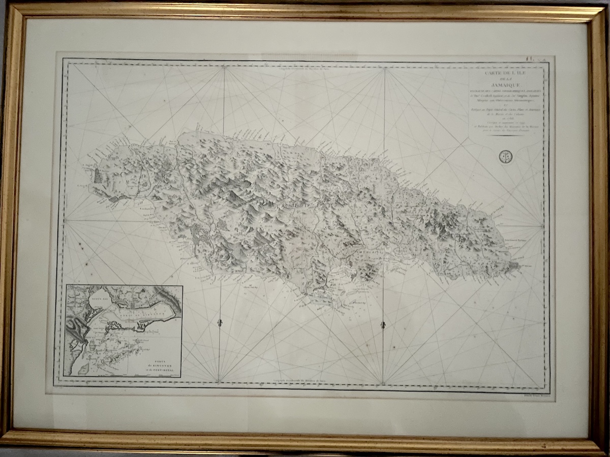
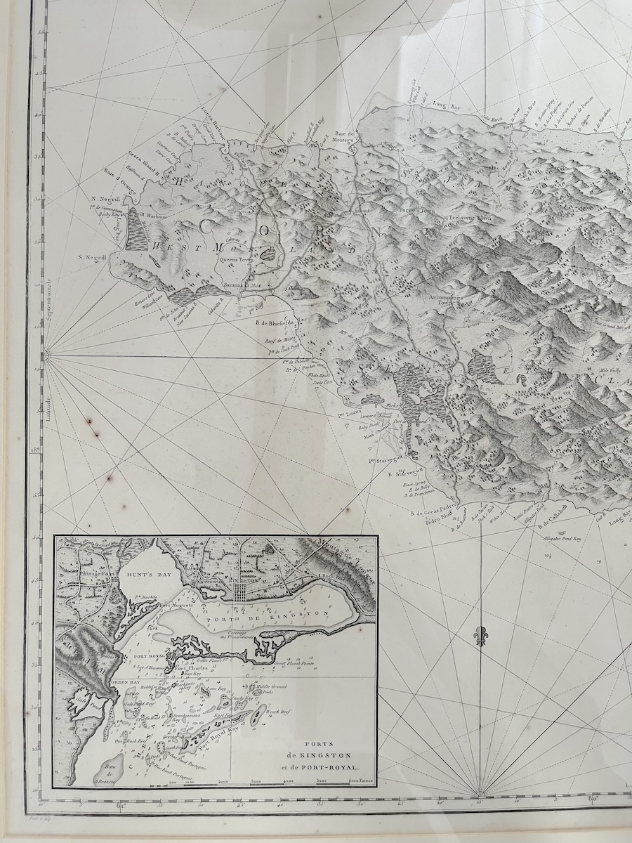
Located at the National Gallery of Jamaica in Kingston is an eighteenth-century map of Jamaica entitled Carte de l’Isle de la Jamaïque (Fig. 1). The map is one of the few eighteenth-century objects held in the museum’s permanent collection. Produced in 1799 by the French Dépôt de la Marine, a French hydrographic mapping organization founded in 1720, the map presents the island of Jamaica with remarkable topographical detail. In creating the map, the cartographer used hachuring and stippling, a cartographic and artistic print technique, to give depth and texture to the island’s mountainous terrain.[1] The cartographer’s use of hachure gives the mountainous interior a pronounced visual form, tracing the central highlands like a spine across the island. In doing so, the cartographer captured the distinctive mountain ranges of Jamaica. The Blue Mountains, for example, with its soaring peaks and dense forests, are located in the eastern part of the island, as shown on the map. The cartographer also charted the Maroon settlements located within the island’s mountain ranges, such as Accompong Town and Moore Town. The coastline is also densely detailed. The names of bays and harbors, such as Montego Bay and Kingston Harbor, identify points of maritime access. On the lower left, an inset of Kingston Harbor brings the harbor’s geography into closer focus, presenting a detailed view of Jamaica’s principal eighteenth-century port (Fig. 2).[2] Surrounding the island is the Caribbean Sea, represented through a complex series of rhumb lines used to chart maritime navigation. Together, these details distinguish Jamaica’s coastal and interior spaces and situate the island within a wider geography of maritime navigation and movement.
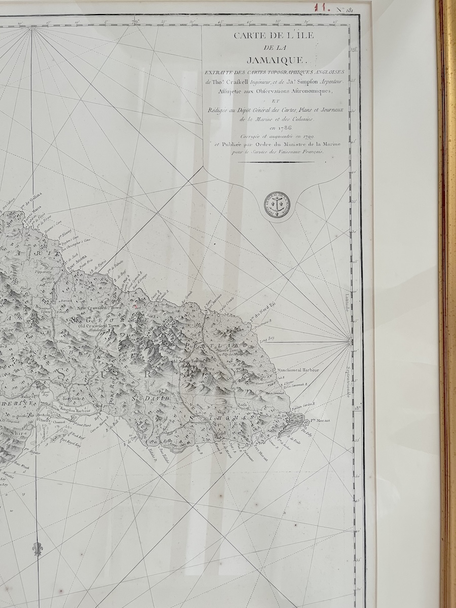
Yet the map does more than document Jamaica’s topographical features and towns. The map itself is an object shaped by cartographic knowledge and colonial interest. The cartouche, located in the upper right corner of the map, provides an important clue into this history (Fig. 3). The French inscription in the cartouche identifies an earlier topographical map made by the English cartographers Thomas Craskell and James Simpson as the map’s source. The Carte de l’Isle de la Jamaïque is thus not an original survey. Rather, the inscription attests to the compilation, correction, and augmentation of Craskell’s and Simpson’s geographic knowledge by the French Dépôt de la Marine in 1799. The Carte de l’Isle de la Jamaïque is also inscribed “prix: Trois Francs” at the lower right, which indicates the map was intended, at some point, to be a commercial item available for purchase. Through the selection, arrangement, and emphasis of geographic information in the Carte de l’Isle de la Jamaïque, the map invites critical reflection on the systems that produced Jamaican landscapes, identities, and histories.
Thomas Craskell’s and James Simpson’s original survey was commissioned by His Majesty’s Lieutenant Governor Henry Moore Esquire, and it was conducted between 1756 and 1761 by traversing the entire island on foot.[3] The map was dedicated to the Earl of Halifax, known as the “Father of the Colonies” and the President of the Board of Trade between 1748-1761.[4] At the time of production, the map made by Craskell and Simpson was considered the most geographically accurate depiction of Jamaica, but it did not fully convey through visual representation the island’s central mountain systems.[5] Produced in 1763, the map gathers basic geographic knowledge of Jamaica’s terrain to combat slave insurrection and Maroon insurgence, especially in the aftermath of the First Maroon Wars (1728-1740) and Tacky’s Revolt (1760-1761).[6] The island’s eastern and western mountain systems played a vital role in the resistance to slavery and colonial oppression. The mountains were not merely physical features within a colonial possession, but inhabited spaces in which colonial authority had been challenged and negotiated.[7] The absence of Jamaica’s mountain ranges in the Craskell and Simpson map obscures this history. Nearly two decades after the map was printed, the map crossed imperial boundaries and became source material for the Carte de L’Ile de la Jamaïque (1799), which extended Craskell’s and Simpson’s depiction of the island.
The differences between the two maps are striking. The Craskell and Simpson survey extensively detailed estates, proprietors, and colonial infrastructure, whereas the map commissioned by the Dépôt de la Marine was more selective in the choice of settlements included and focused on rendering the island’s topography. One detail that remains consistent between the two maps is the documentation of Maroon settlements, placing them within their proximity to British towns, military barracks, and the island’s meandering waterways. On the Carte de L’Ile de la Jamaïque, for example, the Maroon town of Accompong is illustrated in west Jamaica near the Parish of St. Elizabeth; Old Crawford Town, marked on the original map as “deserted,” is translated as “abandoned” in the French version; and New Crawford Town is located in eastern Jamaica (Fig. 4).[8]
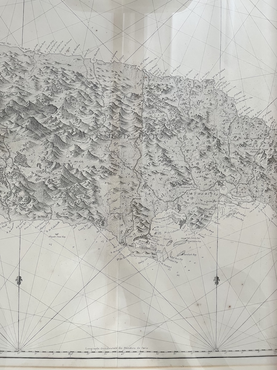
However, unlike the Craskell and Simpson map, the Carte de L’Ile de la Jamaïque places Jamaica’s Maroon towns within a detailed rendering of the island’s mountainous interior. The Carte de L’Ile de la Jamaïque represents the topography of the rugged terrain and renders visible the steep mountain ranges where Jamaica’s Maroon communities established sovereign settlements, such as Accompong Town in Cockpit Country and New Crawford Town in the Blue Mountains. The cartographer even identified the Blue Mountains on the map, engraving “Montagnes Blues” near the mountain range. The Carte de L’Ile de la Jamaïque is also bilingual. There is a deliberate move to transcribe selected locations in French. For example, “Montego Bay” is translated as “Baie de Montego,” while “Long Bay,” a few kilometers to the east, remains unchanged. The bilingual nature of the Carte de L’Ile de la Jamaïque demonstrates that the map was not simply copied but actively translated and reworked as it moved between British and French imperial systems.
In 1999, the Carte de L’Ile de la Jamaïque entered the National Gallery of Jamaica’s collection as part of an initiative by Dr. David Boxer, then chief curator and cofounder of the National Gallery of Jamaica, to establish a topographical map collection at the museum. The map is one of fourteen historical maps gifted to Jamaica in 1999 through a legacy donation from the Matalon family and offers valuable insight into the representation of British colonial Jamaica.[9] The colonial cartographic representation of Jamaica, as the map evidences, did not simply record the island; it actively constructed a colonial understanding of territory, imposing borders, colonial settlements, and administrative divisions that reflected imperial intent and priorities. In this context, surveyors and cartographers became active participants in the production of colonial spaces, transforming landscapes into legible territories for administration, settlement, military planning, and resource extraction.[10]
The map invites critical reflection on the systems that produced Jamaican landscapes, as well as how these landscapes were divided and identified as resources and administrative entities rather than lived spaces shaped by community, memory and resistance. The map as a document embodies successive acts of movement that shaped Jamaica’s history: geographical movement through surveying land; intellectual movement through the transfer of British geographical knowledge into French cartographic practice, and the physical movement from an instrument of empire to a collectable commodity before ultimately entering Jamaica’s National Collection. It also raises questions about how eighteenth-century colonial powers sought to render visible Black geographies, mapping and documenting the locations of Maroons towns across eighteenth-century Jamaica. What becomes visible when the island is mapped and what disappears? Who enabled the survey beyond the named cartographers? And as a museum object, how will the map continue to generate new relationships between the past and the present?
Joelle Salkey is a Conservator at the National Gallery of Jamaica and an Adjunct Lecturer at the Edna Manley College of the Visual and Performing Arts in Kingston, Jamaica
[1] “Depot des Cartes Et Plans de la Marine,” Geographicus Rare Antique Maps, n.d., https://www.geographicus.com/P/ctgy&Category_Code=depotcartes.
[2] The detail of Kingston Harbor is a copy of the “A Chart of Port Royal and Kingston Harbour, in the island of Jamaica” made by J F W DesBarres and published in 1781. See also “Carte de l’Ile de la Jamaique, extraite des Cartes topographiques Anglaises de T. Craskell… et de J. Simpson. Rédigée en 1786, corrigée et augmentée en 1799,” Geographicus Rare Antique Maps, n.d., https://www.geographicus.com/P/AntiqueMap/jamaica-depot-1799
[3] The survey by Thomas Craskell and James Simpson was originally produced in three parts, corresponding to the newly designated administrative counties in Jamaica: Cornwall, Middlesex, and Surrey. The resulting maps were engraved and published in London in 1763. “1763 Craskell and Simpson 3-Part Wall Map of Jamaica,” Geographicus Rare Antique Maps, n.d., https://www.geographicus.com/P/AntiqueMap/jamaica-craskellsimpson-1763.
[4] The Board of Trade was an administrative authority which monitored information gathering in the British Colonies. Maps were an important part of that information infrastructure. See Andrew D.M. Beaumont, Colonial America and the Earl of Halifax, 1748-1761 (Oxford University Press, 2014), 7.
[5] “1763 Craskell and Simpson 3-Part Wall Map of Jamaica,” Geographicus Rare Antique Maps, n.d., https://www.geographicus.com/P/AntiqueMap/jamaica-craskellsimpson-1763.
[6] “Carte de l’Ile de La Jamaïque.” For Tacky’s Revolt, see Vincent Brown, Tacky’s Revolt: The Story of an Atlantic Slave War (The Belknap Press of Harvard University Press, 2020).
[7] In the Maroon Peace Treaties of 1739 and 1740, the British recognized the freedom of the Maroons. SeeAnonymous, “Treaty between the British and the Maroons,” in The Jamaica Reader: History, Culture, Politics, ed. Diana Paton and Matthew Smith (Duke University Press, 2021), 74-77.
[8] Following the violent conflict in 1754, involving a struggle over Maroon leadership and colonial supervision, inhabitants migrated to the neighboring towns of Scotts Hall, New Crawford Town, and Nanny Town. See Campbell C. Mavis, The Maroons of Jamaica, 1655-1796: A History of Resistance, Collaboration and Betrayal (Bergin & Garvey, 1988), 169.
[9] Gifts for the Nation: The Donations of Aaron and Marjorie Matalon (National Gallery of Jamaica, 1999), 7.
[10] B. W. Higman, Jamaica Surveyed: Plantation Maps and Plans of the Eighteenth and Nineteenth Centuries (Institute of Jamaica Publications Limited, 1988), 19.
Cite this article as: Joelle Salkey, “Charting Conquest: Jamaica Surveyed and Commercialized,” Journal18, Issue 22 Archipelago (Fall 2026), https://www.journal18.org/8385.
License: CC BY-NC
Journal18 is published under a Creative Commons CC BY-NC International 4.0 license. Use of any content published in Journal18 must be for non-commercial purposes and appropriate credit must be given to the author of the content. Details for appropriate citation appear above.
