Sophia Bevacqua
From the last quarter of the seventeenth century, French colonial maps of the Caribbean increasingly allocated cartographic space to boundless rocaille ornament. Engraved conchal and bifurcating C-scroll “arabesque” motifs far exceeded earlier map embellishments in scale, performing a range of functions: they announce and encircle map titles, ensnare indigenous figures and detailed views of island harbors, and metamorphose into Caribbean waterways and plant life as though shaped by local climatic conditions (Figs. 1, 2, 3, 7).
Scholarship has framed such rocaille map embellishment as a seductive colonial tool used by royal and bourgeois patrons alike to incentivize investment abroad. Chet van Duzer argues that this style of ornament intimated to investors “the economic possibilities offered by the French holdings in the new world.”[1] Mary Sponberg Pedley similarly connects such ornament to the promotion of colonial resources; for both scholars, the exaggerated scale of ornament imitating natural forms conveyed the productive potential of local crops and the anticipated returns on investment.[2] Cartographic arabesques encircled enlarged views of ports, canals, and rivers linking inland territories to the sea (e.g., Fig. 7), directing the eye to ways in which harvested products entered wider circuits of exchange.[3] Camille Serchuk, Rebecca Zorach, and Tom Conley have further demonstrated how early modern ornamental styles of the metropole—be they French rocaille, Dutch strapwork, or Italian grottesche—signaled the stability of colonial investment by framing remote realms as already part of a familiar world, and access to their resources as “a foregone conclusion.”[4] Yet what of the tropical mutation of this rocaille ornament into the flora, littorals, and peoples of the Caribbean that occurs when it is deployed in Antillean cartographic space, effectively defamiliarizing it as a French style? And how might these transformations complicate the colonial assurances conveyed by cartographic ornament?
This paper proposes an “archipelagic” function of ornament across eighteenth-century French maps of the Caribbean, with four maps serving as case studies. In these maps, the cartographic arabesque captures regionally resonant botanical motifs and human figures from natural histories and colonial accounts, removes them from their surrounding depictions, and twists them together into new graphic configurations within the cartouche that we might think of as archipelagos in their own right, albeit of deracinated fragments. I explore this idea through an ecologically motivated analysis of the scalar manipulation, spatial arrangements, and textual juxtapositions of rocaille embellishment in Antillean cartographic space, alongside a socio-historical investigation of cartouche iconography as transformed by its tropical setting. These visual operations of rocaille, as well as the style’s formal genealogy in aquatic ornament, suggest that this Caribbean cartographic ornamentality participated in period anxieties about degeneration—that is, the belief that tropical climates could alter inherited bodily characteristics and unsettle distinctions that some European writers treated as racial. Thus, alongside their promotion of colonial resources, these maps can be read as registering anxieties about the tropics as a site of transformation, where French forms—ornamental and human alike—risked losing the solidity of their European identities.
The capacity of cartographic ornament to convey such theories of climate depended, in part, on the broader didactic imperative of maps to teach viewers to apprehend colonial environments. As Mireille Pastoureau has demonstrated, early French atlases were created for political and commercial purposes, and were only oriented towards pedagogy in the mid-seventeenth century alongside the expansion of religious education and geographic instruction in support of global evangelization.[5] Illustrations of Caribbean flora and fauna, which circulated through natural histories written by French Jesuit, Dominican, and Huguenot missionaries in the seventeenth century, appear frequently in the ornamental schemes of French as well as British, Dutch, and Spanish maps made at the turn of the eighteenth century. For John Brian Harley, such textually resonate ornamental cartouches “abstracted and epitomized some of the meaning of the [text] as a whole.”[6] By interpolating that meaning into the cartographic realm, such cartouches endowed the maps they adorned with a didactic function.
Likewise, it was toward the end of the seventeenth century that French (and more broadly European) map embellishment became increasingly rocaille in style. Etched and engraved C-scrolls began to expand beyond the confines of frames and cartouches into the surrounding lands and seas, becoming increasingly dominant within the cartographic plane.[7] I would like to argue that this ornamental expansion occurred most frequently and extensively in maps of the so-called torrid zone, conventionally located between the Tropics of Cancer and Capricorn and characterized in early modern European climate writing by extreme heat and excessive humidity.[8] This suggests that artists and patrons of the period deemed rocaille the most suitable style for framing a region distinguished by its climatological wetness and its many islands, characteristics that, in turn, galvanized the style’s greatest expansion and diversity of function. The graphic phenomenon that I’ve identified occurs across European map production in the eighteenth century, with the Englishman John Thornton’s 1706 map of St. Christopher and the Spaniards Jorge Juan and Antonio de Ulloa’s 1748 map of the meridian measured in the Kingdom of Quito serving as particularly compelling examples. To examine the relationship between this canonically French ornamental style and theories of climatic degeneration widely disseminated by French natural historians, I focus on four French maps within which rocaille embellishment carries out archipelagic operations that align this style with the Western tropics. These include maps accompanying two works by the Jesuit missionary Joseph-François Lafitau (1681–1746), together with maps of Saint-Domingue and Martinique produced by cartographers Nicolas de Fer (1646–1720) and Jacques-Nicolas Bellin (1703–1772).
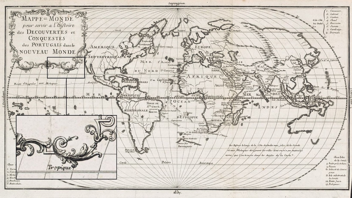
In the world map that unfolds from Lafitau’s 1733 Histoire des découvertes et conquestes des Portugais dans le Nouveau Monde, the spatial relationship between ornament and printed text establishes a deliberate association between rocaille and the tropical zone (Fig. 1). The engraver positioned the arabesque title cartouche just north of the Tropic of Cancer in the Western Hemisphere, with its lower flourish abutting the printed word Tropique. This visual conjunction of ornamental line and cartographic nomenclature encourages the viewer to accept the declarative function of the map, which is to read the rocaille as tropicalized, rather than an exclusively French decorative idiom.
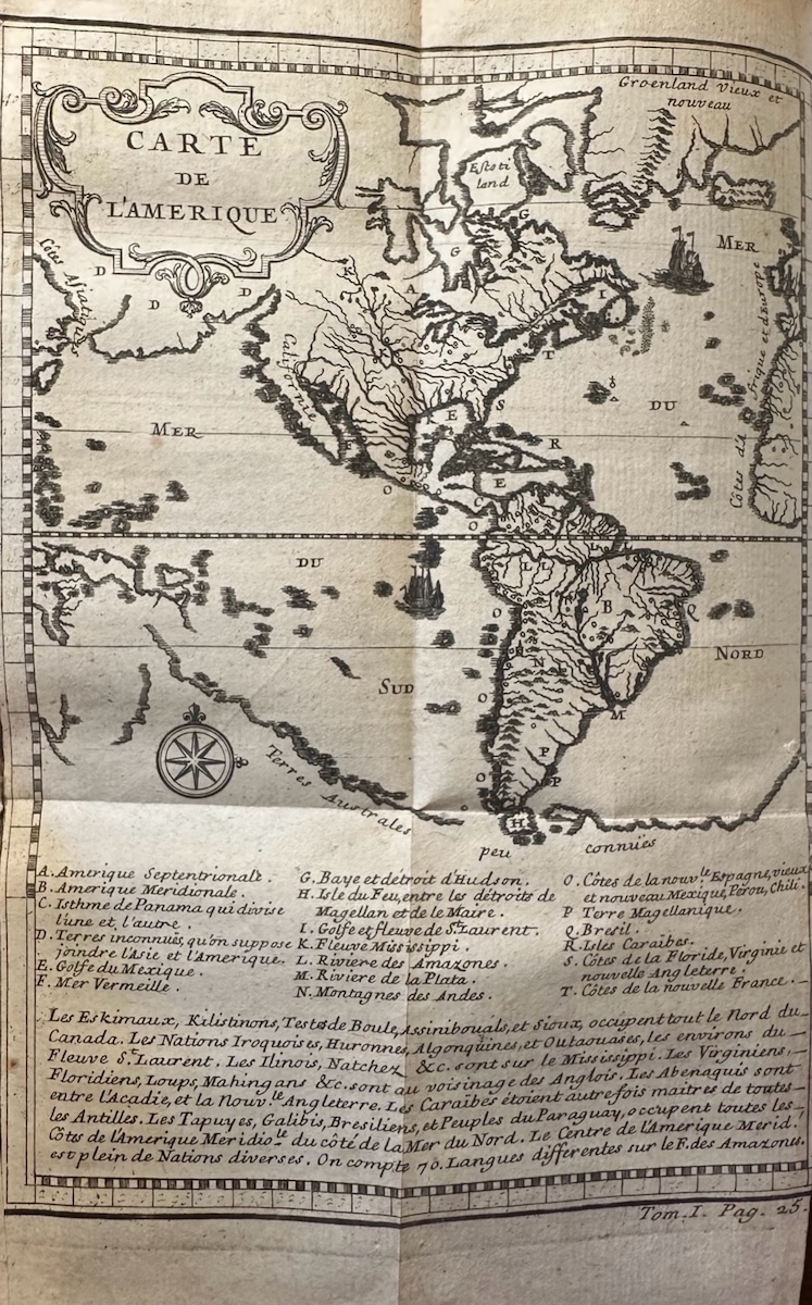
The placement appears more deliberate when the 1733 map is compared with the map engraved for Lafitau’s first major ethnography, the Mœurs des sauvages amériquains, comparées aux mœurs des premiers temps, published nine years earlier. There, on the opening map of the Americas, the cartouche occupies the vacant space above the modern-day Bering Strait, with no comparable alignment between ornament and climatic terminology (Fig. 2). The engraver of the later 1733 Histoire map appears to have reworked the relationship between ornament and text across Lafitau’s publications. Both volumes were published by Saugrain and may have employed the same engraver. In the later map, the arabesque cartouche has been floated southward to the explicitly designated tropical zone, bringing its lower flourish close to the label Tropique.
This graphic maneuver places Lafitau’s 1733 map within a broader cartographic tendency that emerged around the turn of the eighteenth century. Arabesque cartouches similarly appear beside the labeled Tropics of Cancer or Capricorn in maps by Guillaume Sanson, Nicolas de Fer, Guillaume de L’Isle, and Jacques-Nicolas Bellin, among others. This kind of graphic repetition across prints established a visual affinity between rocaille ornament and tropical geography, particularly in the Western Hemisphere. The tropics became a region in which rocaille and arabesque forms flourished.
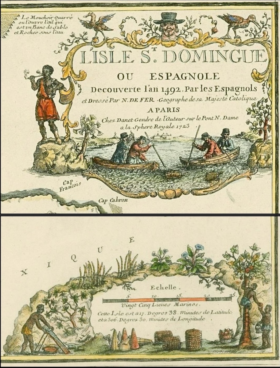
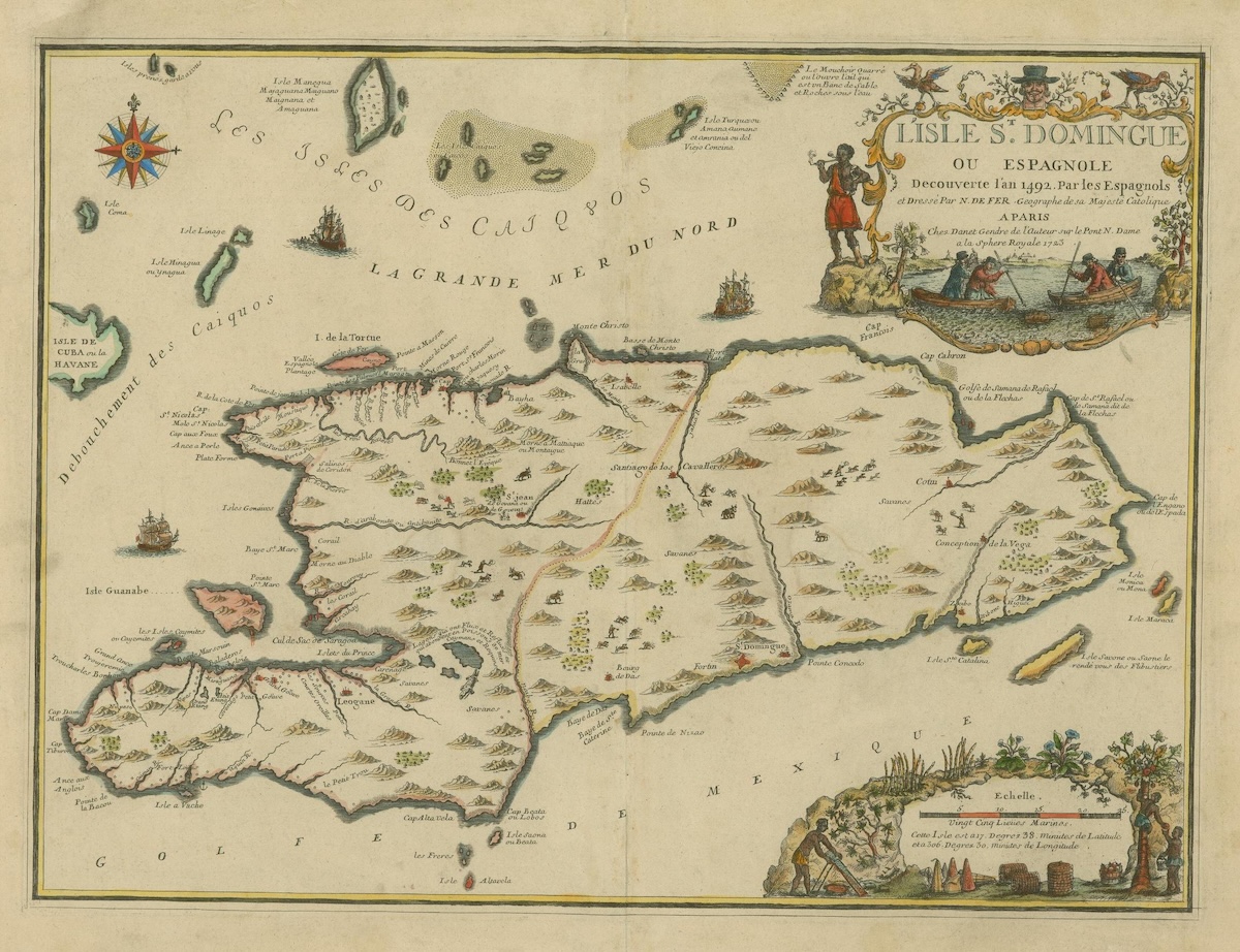
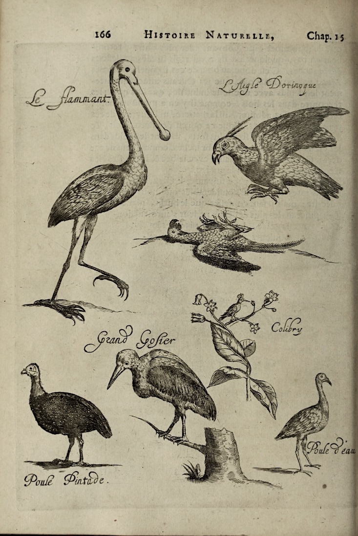
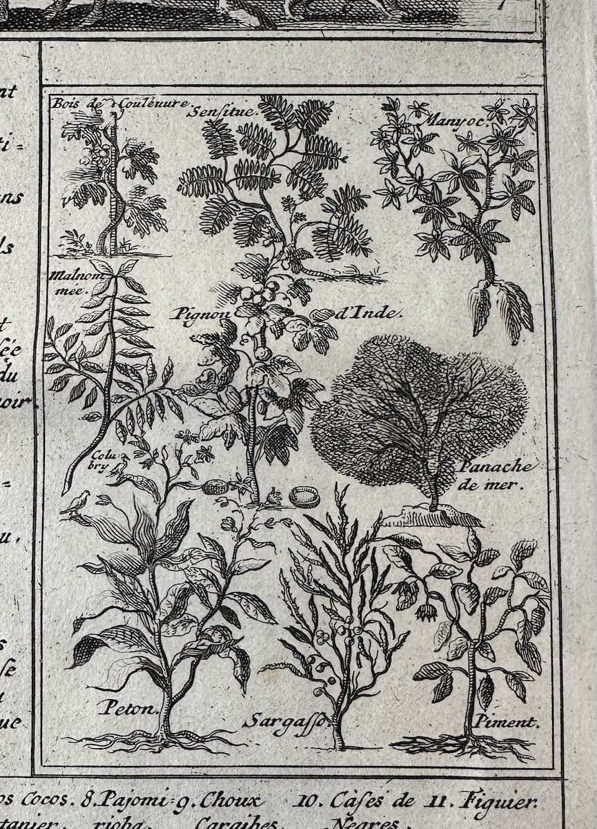
Through the repeated alignment of ornament with tropical land, sea, and text, engraved arabesques in eighteenth-century maps of the Caribbean begin to assume the forms of local plants and animals, as though transformed by tropical conditions. This adaptation is especially visible in the cartouches of Nicolas de Fer’s 1723 map L’isle St. Domingue ou Espagnole Decouverte l’an 1492 par les Espagnols (Fig. 3). Here, the surrounding arabesques merge with stalks of indigo, tobacco (peton), chili pepper (piment), and jatropha (pignon d’Inde) alongside flamingos and pelicans. These representations of local flora and fauna recall illustrations in the 1665 edition of Histoire naturelle et morale des iles Antilles de l’Amerique by the Huguenot minister Charles de Rochefort and in volume VI of Atlas historique by Henri Abraham Chatelain (1719) (Figs. 4, 5, 6).[9] The engraver’s decision to render a kind of environmental adaptation of the ornament links the charted territories to the crops they produce and, by extension, to the humid tropical climate that enabled their cultivation.
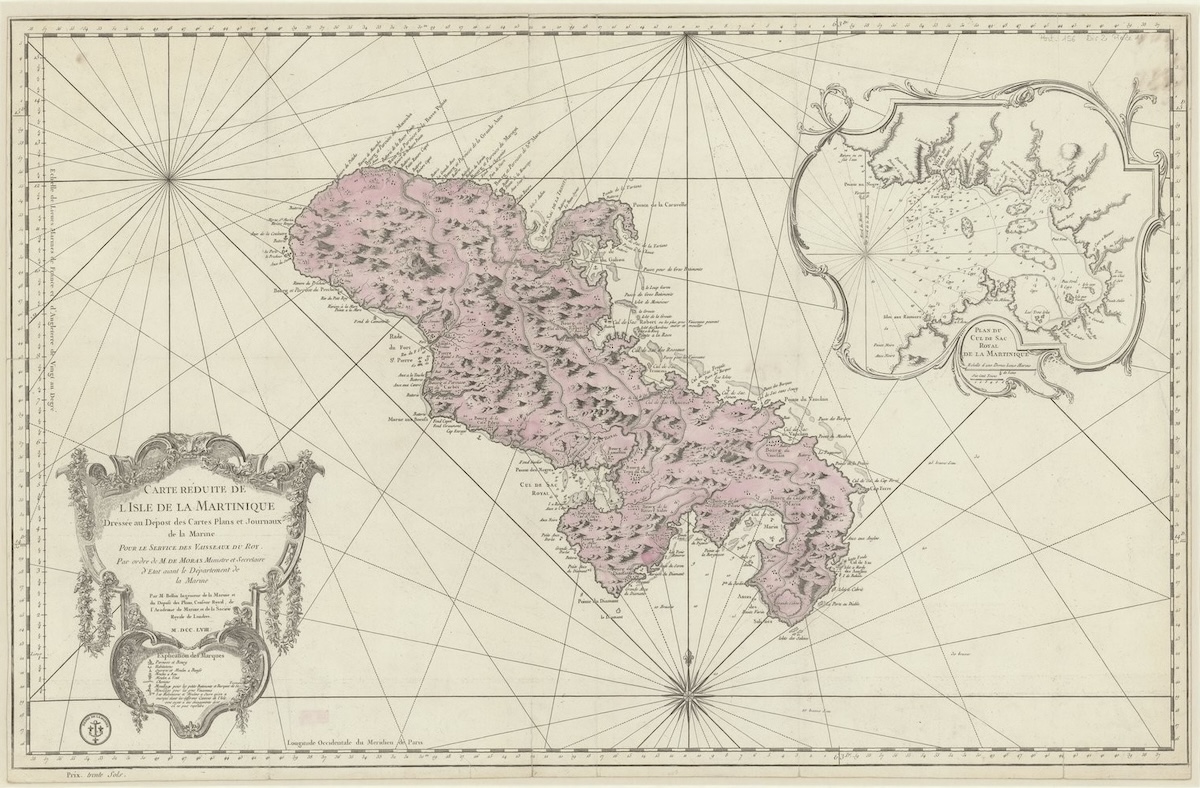
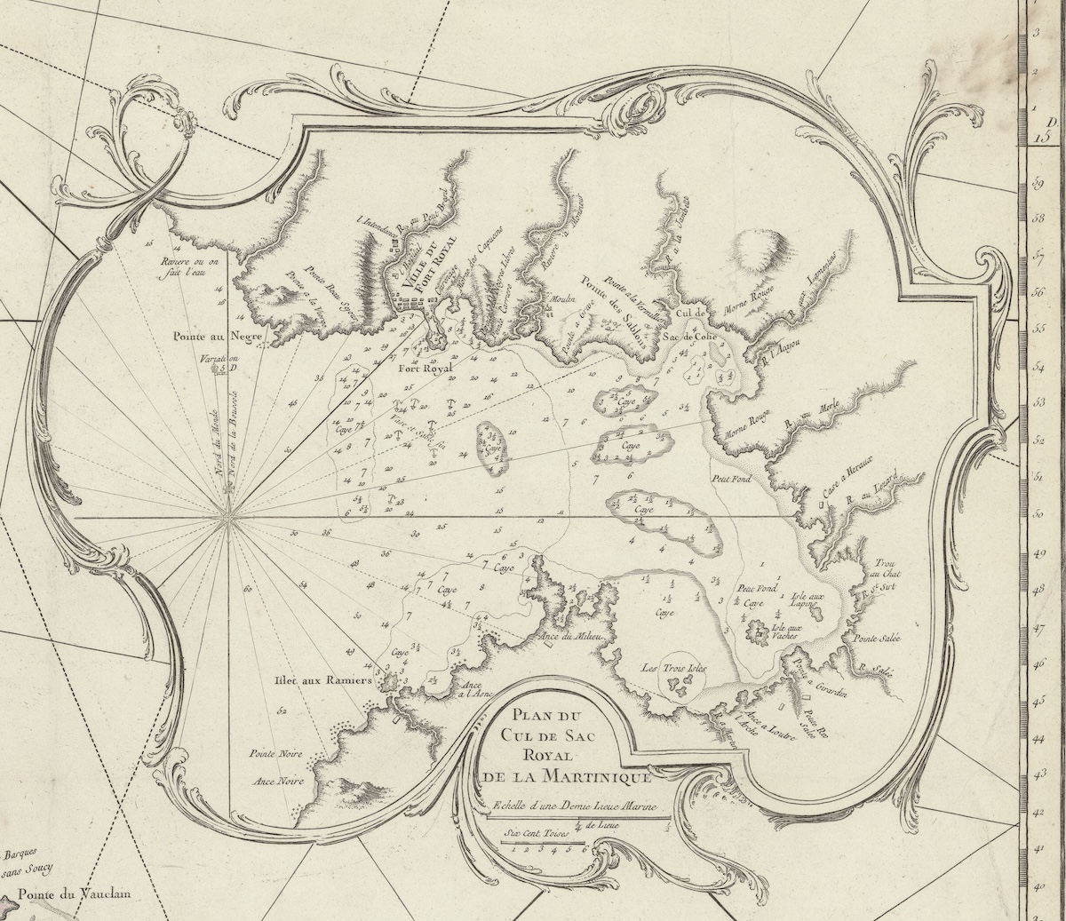
Confronted with these depictions of water that both envelops shores and permeates the air, it is little wonder that these maps teem with rocaille ornament. One need only consider the aquatic origins of the style. Its ornamental vocabulary abounds in shells, corals, algae, and streams of rushing water frozen in motion, joined by sinuous arabesque lines.[10] These oceanic ornamental configurations recall the shell-encrusted grottoes beneath Renaissance palaces that Hans Sedlmayr and Hermann Bauer identified as important precedents for the rocaille.[11] The aquatic character of rocaille is especially evident in the inset map of the Cul-de-Sac Royale in Jacques-Nicolas Bellin’s 1758 map of Martinique (Fig. 7), where the undulating curves of the rocaille border become nearly indistinguishable from the serpentine lines of nearby coastlines and rivers. Encircling a detailed view of an inlet dense with ports and waterways, the ornamental tendrils seem to extend the richly veined potamography (Fig. 8).
The evaporation of these rivers contributed to the intense humidity of the region, a condition described by European writers who visited the West Indies from the fifteenth century onward.[12] Here again, rocaille appears to adapt to local ecological forms within Caribbean cartographic space. In Bellin’s map, however, the aquatic dimensions of rocaille surge beyond the mere imitation of aqueous forms. His rocaille ornament also assumes the aqueous function of dissolving formal boundaries. Karsten Harries has identified this solvent quality as fundamental to the style, describing the rocaille frame as, first and foremost, “a boundary … rendered indefinite.”[13] “The frame, we can say, has entered the picture,” writes Harries, though in Bellin’s map, the frame additionally blurs the distinction between differently scaled views of Martinique and, more broadly, between art and nature, as rocaille merges visually with the tropical forms it represents.[14]
This aesthetic of dissolution posed a danger to the classificatory practices of the Enlightenment because it threatened the formal stability on which rigid taxonomies depended. Eighteenth-century art critics often criticized the illusionistic dissolution of form in rocaille, but the destabilizing effects of the style could extend beyond the decorative.[15] Through its metamorphosis under torrid climatic conditions and its ensnarement of nonwhite figures associated with that planetary zone, rocaille map ornament threatened to dissolve not only physical form but also the biological categories of race that seventeenth- and eighteenth-century natural historians were beginning to formulate in Western thought.[16]
The stakes of this ornamental dissolution become clearer when considered alongside contemporary theories of degeneration, which similarly imagined torrid climates as capable of transforming European bodies across supposedly stable racial boundaries.[17] In their most consequential formations, theories of degeneration held that individuals from temperate zones could undergo irreversible physical change when exposed to hot and humid climates beyond Europe.[18] Even the etymology of “degenerate” reflects the classificatory logic of this idea: The Latin prefix de- denotes movement “away from,” while genus signifies “race” or “kind.” To degenerate, then, was to depart from the bodily form associated with one’s proper race and, for European writers, ultimately from whiteness.[19]
This logic found one of its most influential formulations in the Histoire naturelle by Georges-Louis Leclerc, the Comte de Buffon. Published in 36 volumes between 1749 and 1789, the work was among the most widely read works of the eighteenth century. In the third volume, Buffon argued that “it appears that, with time, a white people transported from the north to the Equator could become brown, and even completely black.”[20] He also described degeneration as a softening of the bones and tissue through tumors and other diseases caused by excessive humidity. Buffon’s account emerged from a much longer discourse on hot climates, extending from Parmenides and Aristotle through Roger Bacon and Guillaume Delisle into colonial medical treatises, travel narratives, natural histories, and personal and administrative correspondence. Together, these sources formed an ethnographic archive that repeatedly associated tropical climate with physical decay and, by extension, racial instability.[21]
As a center of slavery under European colonial rule, the humid Caribbean became a crucial site for eighteenth-century theories of degeneration. European accounts of physical decline among colonists, attributed to torrid climatological immersion and interracial proximity, helped give form to the claims advanced by Buffon.[22] To settle in the Caribbean, in this view, was to risk bodily corruption and an erosion of recognizable form, a process that early modern thought linked to a corresponding departure from an idealized white physiological identity. Humidity, in particular, was to blame. Chatelain, writing about the Caribbean, claimed that daytime heat opened pores, allowing moisture from the night air to penetrate them and bring about “the corruption and short lifespan of everything under the Torrid Zone.”[23]
Within eighteenth-century maps of the Caribbean, humidity-induced degeneration emerges as a recurring visual logic articulated through an ornamental style associated with moisture. In this cartographic space, rocaille not only metamorphoses into local flora and littoral forms but also incorporates nonwhite figures within its arabesque branches (Figs. 3, 4). Like the torrid Caribbean climate, the ornament appears to “soften” both the rigidity of formal boundaries, such as frames, and the stability of Enlightenment racial categories. Through strategies of scalar manipulation, botanical and aquatic mimicry, and the visual entrapment of racialized bodies, these maps render rocaille increasingly unstable in its relationship to its French stylistic origins. The ornament becomes a visual index of degeneration: As it enters the Caribbean, it loses the formal and cultural coherence associated with hexagonal France, becoming instead entangled with local vegetation, waters, and racialized inhabitants. Caribbean cartographic ornament could thus function as a cautionary visualization of the perceived capacity of torrid climates to transform and ultimately estrange forms understood as native to France.
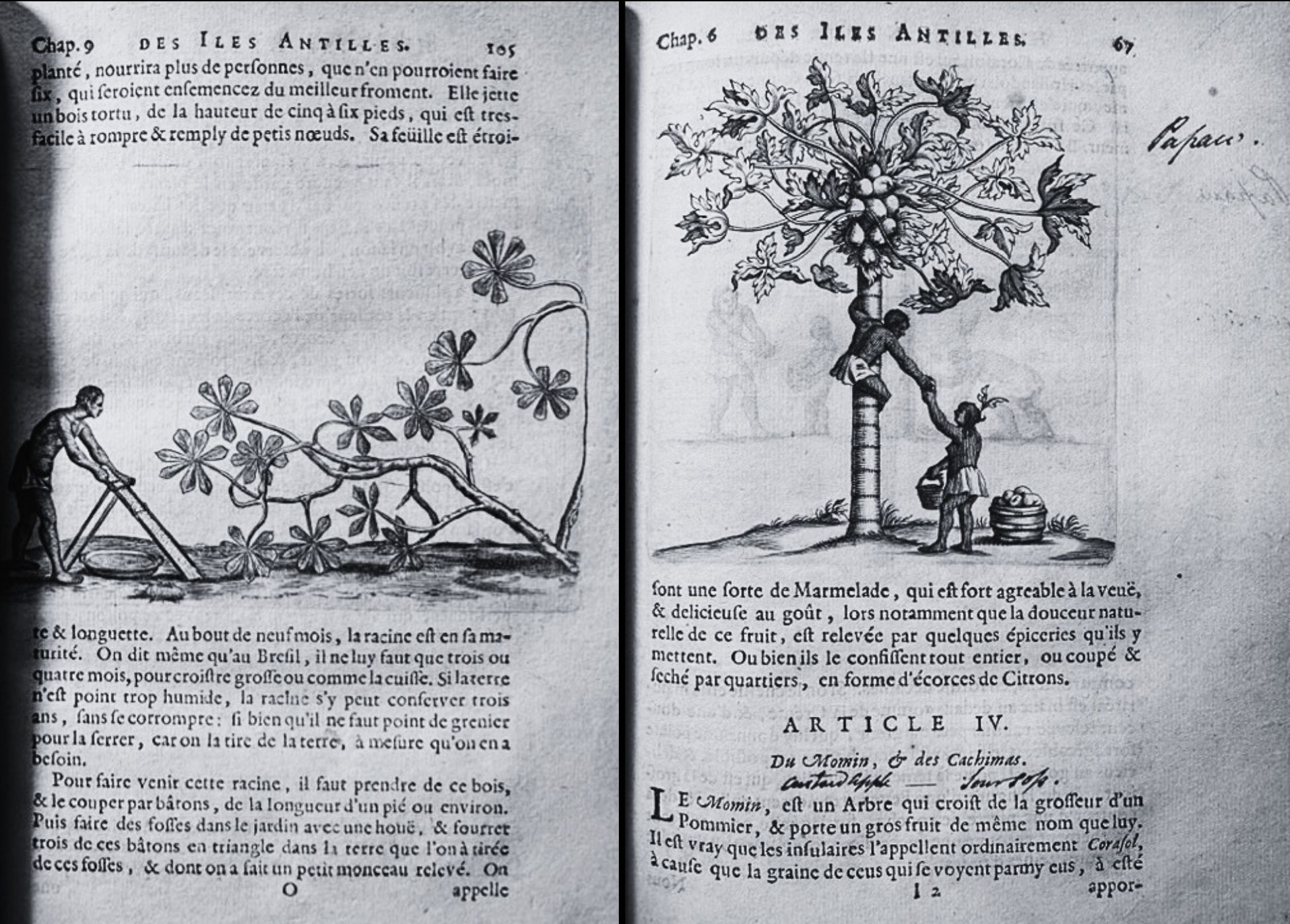
The dark-skinned figures enclosed by the ornament in Nicolas de Fer’s 1723 map of St. Domingue (Fig. 4)offer an especially striking visual allusion to Caribbean degeneration and the bodily deterioration associated with it.[24] The cartouche hovering off the southern coast of the island contains three laboring figures drawn directly from the illustrations accompanying the manyoc (cassava) and papayer entries in Charles de Rochefort’s Histoire naturelle et morale des iles Antilles de l’Amerique, one of the earliest French natural-historical and ethnographic accounts of the Caribbean, published nearly six decades earlier (Fig. 9).[25] Although de Rochefort identifies these figures as Indigenous, their racial identity remains visually indeterminate in both the seventeenth-century illustrations and de Fer’s map. Their darkened skin tone and other graphic features allow them to be read more broadly within the racialized visual field of the colonial Caribbean, without securely identifying them as either Indigenous or African. This ambiguity contrasts with the taxonomic legibility of colonial casta painting and Albert Eckhout’s seventeenth-century representations of different populations in northeastern Brazil, where carefully calibrated skin tones, costumes, attributes, and labels work to differentiate subjects within a colonial system of classification.[26] Against these comparanda, the racial ambiguity of the de Rochefort and de Fer figures becomes significant. Rather than fixing racial identity, the images collapse distinctions among nonwhite laboring bodies within a colonial visual economy shaped by enslavement, which is repeatedly described in the Caribbean natural histories of de Rochefort, du Tertre, Jean-Baptiste Labat, and Richard Ligon, among others.[27]
Reading de Rochefort’s manyoc entry suggests that de Fer’s visual engagement of his scientific predecessor extends beyond the vignettes of laboring figures, along subtler, more morbid lines. De Rochefort recounts that the Indigenous people of Hispaniola drank the poisonous juice of the manyoc plant to end their lives rather than endure Spanish cruelty. According to his account, the so-called “Cave of the Indians” in Saint-Domingue contained the bones of more than 400 Indigenous people who made this impossible choice.[28] De Fer may have seized upon these gruesome textual details in the eighteenth century, situating de Rochefort’s manyoc juicer in front of a verdant cave of his own design.[29] Rather than depicting the bones described by de Rochefort, however, the cave contains the scale and geographic coordinates of the map. In the words of Mary Carruthers, “ornament explains how the mental instruments of [the text] are to be played.”[30] Read alongside de Rochefort’s account, de Fer’s ornament forces his viewer into an epistemological relationship with the charted island that hinges on the following proviso: The key to decoding this foreign land is not simply geometry but an immersive reckoning with the literal rotting away of one people to make way for the degeneration of the next.
Embellished maps of the Caribbean placed rocaille ornament and the humid local climate in a mutually reinforcing relationship. As if imitating the archipelagic topography they surrounded, engraved arabesques reefed together disparate cartographic scales and textual sources. This brought to maps a sense of tropical aggregation that echoed processes of colonial appropriation while also registering the perceived risks of colonial settlement. By assuming the form of local Caribbean plant life and laboring figures, as though mutated and thus defamiliarized by the local climate, map ornament intimated that European settlers likewise risked physical degeneration in these climes.
Sophia Bevacqua is a PhD candidate in art history at the Institute of Fine Arts at New York University
[1] Chet van Duzer, Frames That Speak: Cartouches on Early Modern Maps (Brill, 2023), 168.
[2] Mary Sponberg Pedley, The Commerce of Cartography: Making and Marketing Maps in Eighteenth-Century France and England (University of Chicago Press, 2005), 56; van Duzer, Frames That Speak, 56–7.
[3] van Duzer, Frames That Speak, 121, 125, 153.
[4] Camille Serchuk, Lies of the Land: Painted Maps in Late Medieval and Early Modern France (Penn State University Press, 2025), 67. See also Rebecca Zorach, Blood, Milk, Ink, Gold: Abundance and Excess in the French Renaissance (University of Chicago Press, 2005), 155–58, and Tom Conley, The Self-Made Map: Cartographic Writing in Early Modern France (University of Minnesota Press, 1996),211.
[5] Mireille Pastoureau, “French School Atlases: Sixteenth to Eighteenth Centuries,” in Images of the World: The Atlas Through History, ed. John Wolter and Ronald Grim (Library of Congress, 1997), 111.
[6] John Brian Harley, “Power and Legitimation in the English Geographical Atlases of the Eighteenth Century,”in Wolter and Grim, Images of the World, 184.
[7] Caroline Heering, “Évolution et mutation du cartouche dans l’art de nos régions du XVIe au XVIIIe siècle,” in Actes du 8e Congrès de l’Association des Cercles francophones d’Histoire et d’Archéologie de Belgique et 55e Congrès de la Fédération des Cercles d’Archéologie et d’Histoire de Belgique (Namur: Presses universitaires de Namur, 2011), 857–68. Van Duzer, Frames That Speak, 24–37, and Serchuk, Lies of the Land, 170–74, outline a similar stylistic trajectory of early modern cartographic ornament.
[8] To reach this conclusion, I surveyed more than 1,200 maps across multiple editions of atlases, travel books, natural histories, and standalone prints, published primarily in France and Britain, but also in Spain and the Netherlands, between 1675 and 1804. More than half of the maps depicting regions within the torrid zone featured rocaille ornament occupying over one-sixth of the map area, as measured using a superimposed grid. In approximately one-quarter of the atlases containing maps of multiple world regions, maps of torrid-zone areas, including the Caribbean, displayed markedly more extensive rocaille ornament than maps of other regions in the same volume. This geographic discrepancy is especially pronounced in editions of Thornton’s The English Pilot published between 1706 and 1798, Bellin’s atlases, and Le Gentil de la Barbinais’s Nouveau voyage autour du Monde (1725). For discussions of the long history of European discourse on the torrid zone, see Marie Sanderson, “The Classification of Climates from Pythagoras to Koeppen,” Bulletin of the American Meteorological Society 80, no. 4 (1999): 669–73; L. H. Roper, ed., The Torrid Zone: Caribbean Colonization and Cultural Interaction in the Long Seventeenth Century (University of South Carolina Press, 2018).
[9] See Charles de Rochefort, Histoire naturelle et morale des iles Antilles de l’Amerique (Rotterdam: Arnout Leers, 1665), and Henri Abraham Chatelain, Atlas historique, tome VI (Amsterdam: L’Honoré & Chatelain, 1719). For a history of French missionaries who functioned as natural historians in the colonial Caribbean, see James McClellan, Colonialism and Science: Saint Domingue and the Old Regime (University of Chicago Press, 2010).
[10] Hermann Bauer, Rocaille (Walter de Gruyter & Co, 1962); Hans Sedlmayr, “Zur Charakteristik des Rococo,” in Manierismo, Barocco, Rococo: concetti e termini Relazioni e Discussioni (Academia Nazionale Dei Lincei, 1962), 343–51.
[11] Hermann Bauer and Hans Sedlmayr, “Rococo,” Encyclopedia of World Art, vol. 12 (McGraw-Hill, 1966), cols. 230–74.
[12] For period writing on the catastrophic effects of Caribbean humidity on European bodily constitution, crops, and architecture, see José de Acosta, Historia Natural y Moral de las Indias (1590); Jean-Baptiste-René Pouppé Desportes, Histoire des maladies de S. Domingue (Paris: Chez Lejay, 1770);James Johnson, The Influence of Tropical Climates on European Constitutions (London: J. J. Stockdale, 1813); Karen Ordahl Kupperman, “Fear of Hot Climates in the Anglo-American Colonial Experience,” William and Mary Quarterly 41, no. 2 (1984): 213–40; Roper, The Torrid Zone.
[13] Karsten Harries, The Bavarian Rococo Church: Between Faith and Aestheticism (Yale University Press, 1983), 80.
[14] Harries, The Bavarian Rococo Church, 211.
[15] In his “Supplication aux Orfèvres, Ciseleurs, Sculpteurs en bois pour les appartemens & autres,” Mercure de France (December 1754): 180, Charles-Nicolas Cochin criticized rocaille ornament for changing the intended function of objects. He argued that a candlestick should stand straight to support the light and that its bobèche should be concave to catch dripping wax; a twisted stem and convex bobèche sacrificed those functions to ornamental effect. For a broader account of contemporary criticism of rocaille, see Bauer, Rocaille, 63–6.
[16] Andrew S. Curran, Biography of a Dangerous Idea: A New History of Race from Louis XIV to Thomas Jefferson (Other Press, 2026), 171, 175–80, 207, 249–50, 283–5, 289, and 326–32.
[17] See Andrew S. Curran, The Anatomy of Blackness: Science and Slavery in an Age of Enlightenment (Baltimore: Johns Hopkins University Press, 2011), 107–13, 159–60; and Phillip R. Sloan, “The Idea of Racial Degeneracy in Buffon’s Histoire naturelle,” Studies in Eighteenth-Century Culture 3 (1973): 293–321.
[18] For such formations, see the Comte de Buffon’s Histoire naturelle (discussed at length in Curran’s works cited in notes 16–17); Pierre Barrère, Dissertation sur la cause physique de la couleur des nègres, de la qualité de leurs cheveux, et de la dégénération de l’un et de l’autre (Paris: P. G. Simon, 1741); Montesquieu, De l’esprit des lois (A Geneve, Chez Barrillot & Fils, 1748); Cornelius de Pauw, Recherches philosophiques sur les Américains (Berlin, 1771); and in Johann Friedrich Blumenbach’s De generis humani varietate nativa (Göttingen: Friedrich Andreas Rosenbusch, 1775), De generis humani varietate nativa liber, 2nd ed. (Göttingen: Widow of Abraham Vandenhoeck, 1781), and his essay “Über den Bildungstrieb (Nisus formativus) und seinen Einfluß auf die Generation und Reproduction,” Göttingisches Magazin der Wissenschaften und Litteratur 1, no. 5 (1780): 247–66.
[19] For the Latin etymology, see Charlton T. Lewis and Charles Short, A Latin Dictionary (Oxford: Clarendon Press, 1879), s.v. “dēgener.” See also Curran, Anatomy of Blackness, 110–11.
[20] “Il y a apparence qu’avec le temps un peuple blanc transporté du nord à l’équateur pourrait devenir brun et même tout-à-fait noir,” Buffon, Histoire naturelle, vol. 3 (Paris, 1749), 482–3 and 91–5.
[21] See, for instance, Jean-Baptiste Christian Aublet, Histoire des plantes de la Guiane françoise, vol. 1 (London and Paris: Pierre-François Didot jeune, 1775), xv; Jean-Baptiste-René Pouppé Desportes, Histoire des maladies de S. Domingue (Paris: Lejay, 1770); Antoine Poissonnier-Desperrières, Traité des fièvres de l’isle de St. Domingue (Paris: L’Imprimerie Royale, 1780); Antoine Bertin, Des moyens de conserver la santé des blancs et des négres, aux Antilles ou climats chauds et humides de l’Amerique (Saint-Domingue and Paris: Méquignon l’aîné, 1786); and Colin Chisholm, Manual of the Climate and Diseases of Tropical Countries (London: Burgess and Hill, 1822).
[22] Yvonne Fabella has written extensively on the degenerative implications of creolization in the Caribbean, particularly in relation to climate and interracial proximity. Most relevant here is “Redeeming the ‘Character of the Creoles’: Whiteness, Gender and Creolization in Pre-Revolutionary Saint Domingue,” Journal of Historical Sociology 23, no. 1 (2010): 41–2 and 55.
[23] Chatelain, Atlas historique, tome VI, 156: “De là vient la corruption & le peu de durée de tout ce qui est sous la Zone Torride.”
[24] I use the term dark-skinned as a visual descriptor for figures represented with darker complexions in the maps under discussion, rather than as an assertion of racial or cultural identity. The term acknowledges the difficulty of assigning modern identity categories to historical images while providing a consistent way to describe their depiction. On the contingency of racial and ethnocultural categories and the resulting ambiguity of visual identity in the early modern Caribbean, see Mia L. Bagneris, Colouring the Caribbean: Race and the Art of Agostino Brunias (Manchester University Press, 2018); Tessa Murphy, The Creole Archipelago: Race and Borders in the Colonial Caribbean (University of Pennsylvania Press, 2021).
[25] De Rochefort, Histoire naturelle, 67, 105.
[26] Later in the eighteenth century, Agostino Brunias, a painter working for the Caribbean plantocracy, similarly rendered nonwhite figures with deliberate visual ambiguity in idealized scenes of colonial life. As Mia L. Bagneris argues, this ambiguity invited viewers into a “complex visual reckoning of race” amid the growing ethnocultural diversity of the eighteenth-century Caribbean. See Bagneris, Colouring the Caribbean, 188.
[27] Accounts of the enslavement of Indigenous and African peoples, and of increasing colonial dependence on their labor, recur throughout de Rochefort, Histoire naturelle (1665), Jean-Baptiste Du Tertre, Histoire générale des Antilles habitées par les François (Paris, 1667), Richard Ligon, A True and Exact History of the Island of Barbados (1657), and Jean-Baptiste Labat, Nouveau voyage aux Isles de l’Amérique (1722). On the enslavement of Indigenous peoples in the Caribbean, see the first chapter of Doris L. Garraway, The Libertine Colony: Creolization in the Early French Caribbean (Durham, NC: Duke University Press, 2005), 39–92. Garraway distinguishes the histories of the Taíno and the Caribe, including resistance to colonial enslavement among the latter. Here, “Indigenous peoples” refers specifically to people described as enslaved in the cited accounts; it does not exclude the Caribe from Indigenous peoples as a whole.
[28] De Rochefort, Histoire naturelle, 106.
[29] This “Cave of the Indians” may correspond to the cave depicted in the map of Central America and the Antilles in the Vallard Atlas (1547),produced nearly two centuries earlier.
[30] Mary Carruthers, The Craft of Thought: Meditation, Rhetoric, and the Making of Images, 400–1200 (Cambridge University Press, 2000), 116.
Cite this article as: Sophia Bevacqua, “The Archipelagic Function of Ornament,” Journal18, Issue 22 Archipelago (Fall 2026), https://www.journal18.org/8302.
License: CC BY-NC
Journal18 is published under a Creative Commons CC BY-NC International 4.0 license. Use of any content published in Journal18 must be for non-commercial purposes and appropriate credit must be given to the author of the content. Details for appropriate citation appear above.
