
Maria Georgopoulou
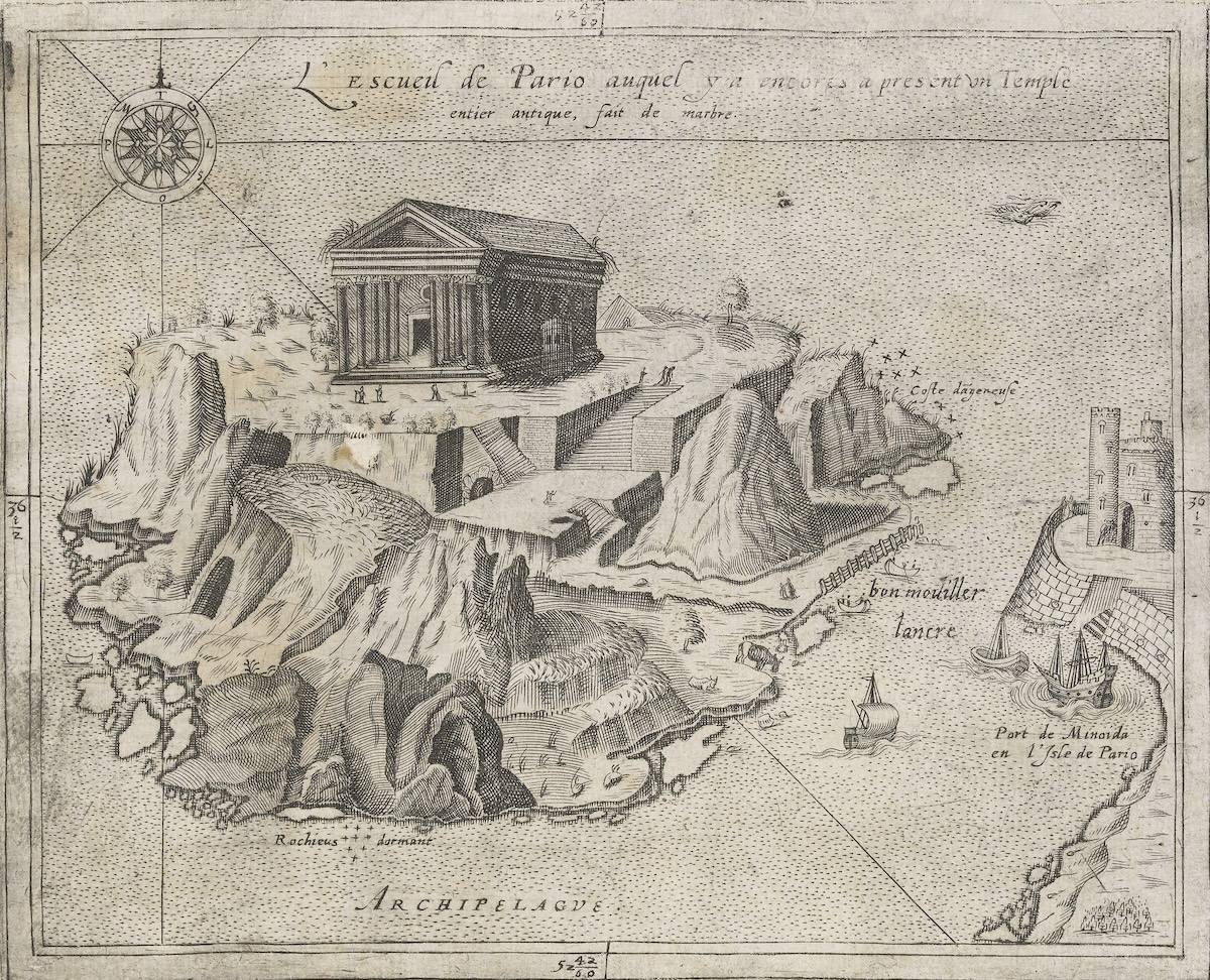
Charting the Aegean archipelago can be understood as a history of changing ways of seeing. From the Renaissance onward, maps and illustrated accounts presented the islands within different geographical and historical frameworks. A representation of an islet near Paros from the unfinished Grand Insulaire of the French cosmographer André Thevet (1516–1590), held at the Gennadius Library in Athens, is a case in point (Fig. 1).[1] Titled “L’ escueil de Pario auquel y a encore a present un temple entier antique, fait de marbre,” this image is dominated by the depiction of an ancient marble temple. Thevet, a Franciscan friar who traveled through the eastern Mediterranean between 1549 and 1552, assembled detailed maps, or rather bird’s-eye views, of individual islands that offered an encyclopedic visualization of the Aegean. Drawing on existing knowledge, these representations made the islands intelligible to elite audiences in Western Europe while largely leaving local interlocutors unacknowledged. A fragmented and potentially dangerous maritime world, whose navigation depended wholly on intimate local knowledge, became legible as a geographical and historical space through the “omniscient” perspective of the cosmographer and his readers.[2] What changed over time, in response to political exigencies, was how the islands were represented, for whom, and for what ends.
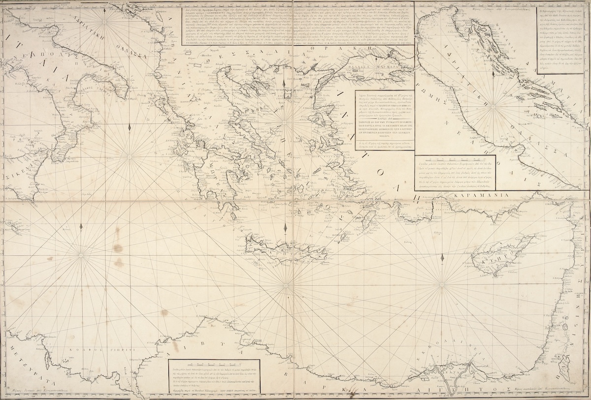
Representations of the Aegean drew on European cosmographic and antiquarian practices, navigation, trade, and local knowledge. During the eighteenth century, these overlapping practices also acquired new political uses. A nautical map of the central and eastern Mediterranean, drawn by Nikolaos Kephalas, a Greek sea captain from Zakynthos, and printed in Paris in 1818, offers a glimpse of this development (Fig. 2). The detailed chart centers on the Aegean Archipelago, while the use of Greek in its legend and throughout situates the region within what would become recognized as a modern state independent from the Ottoman Empire.[3] Published three years before the Greek Revolution, it belongs to a period when the cartographic representation of Greek space was acquiring increasing political significance. Following the Revolution of 1821, maps and historical images helped articulate competing understandings of Greek national space; put another way, the archipelago was mobilized for the articulation of a Greek national imaginary.[4] In this context, the role of cartography extended beyond scientific description to encompass relationships between geography, historical memory, and political belonging. Maps made the Aegean visible, knowable, memorable, and ultimately claimable. The question, then, is how successive forms of representation brought the islands into relation with one another, and how these changing configurations of the archipelago gave geographical knowledge new historical and political meanings.
From Islands to Archipelago
In the centuries following the Fourth Crusade, the Aegean occupied a crucial position within the political and intellectual geography of the early modern Mediterranean. It was a contested maritime region in which Byzantine, Venetian, Genoese, other Latin, and, later, Ottoman political interests intersected. These overlapping claims provided an important context for geographical representation. Renaissance scholars, in particular, approached the islands as a productive terrain where geographical knowledge inherited from ancient texts could be compared with contemporary observation. The Aegean increasingly came to be represented as a coherent geographical whole: the Archipelago. Individual islands could be surveyed, classified, measured, and incorporated into a larger system of geographical and cosmographic knowledge. They retained their distinctive topographies, especially as sites of antiquarian interest, but their particularity was increasingly understood within a larger spatial order.
Michel de Certeau’s distinction between strategies and tactics offers a way to consider the relationship between spatial knowledge, scale, and power.[5] Strategies depend on a position from which spatial relationships can be surveyed and organized, while tactics belong to those who inhabit another’s space and must respond to conditions they do not control. This distinction can be particularly useful when applied to the early modern Aegean. For the humanist cosmographer, the archipelago could be apprehended strategically as a coherent whole, available to readers removed from the world it depicted. For the majority of those who inhabited and navigated it, however, the sea was fragmented, unpredictable, and potentially dangerous. Their knowledge was situated rather than detached, grounded in familiarity with coastlines, winds, currents, passages, harbors, and neighboring islands. Though rarely acknowledged in travelers’ accounts, local expertise was essential to navigating these waters safely. Pilots, guides, and local storytellers also supplied the knowledge and curiosities that travelers sought. In this sense, those who inhabited the archipelago did more than help others navigate it: local experience also defined its boundaries, offered an intellectual framework for grasping its particularities, and guided the cosmographers’ gaze.
Cosmographic representation thus performed a kind of domestication, making the Aegean familiar and accessible to readers who might never travel there. By selecting and arranging geographical information, maps offered frameworks through which the islands became objects of European knowledge, travel, and political interest. In the process, the archipelago became more than a distant and unfamiliar world: it could be surveyed, studied, traversed, and even imagined as a space to be possessed.
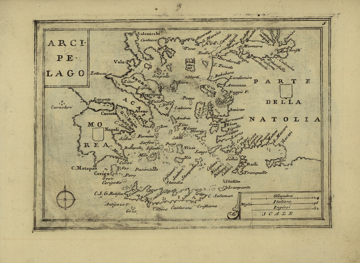
This connection between cartography and territorial ambition is particularly clear in Venetian mapmaking, which contributed to the commercial and political presence of the Republic in the Aegean and the Levant.[6] Following the loss of Crete to the Ottomans in 1669, the official Venetian cosmographer Vincenzo Coronelli (1650–1718) produced maps that evoked the Republic’s former dominion and supported territorial claims during the Morean War (1684–1699) and its aftermath. Around 1707, he compiled the Arcipelago, bringing individual Aegean islands, many formerly under Venetian rule, into a single cartographic frame (Fig. 3).
The Antiquarian Archipelago
Cosmographic representations depended upon knowledge acquired through travel and direct observation. Renaissance antiquarianism was central to this process. The Florentine Cristoforo Buondelmonti (c. 1385–c. 1430), who traveled extensively through the Aegean in the early fifteenth century, combined geographical description with the study of antiquity in his Liber insularum archipelagi, generally regarded as the first isolario (book of islands).[7] His descriptions and images presented the islands as places where the ancient Greek past could be encountered materially through temples, ruins, landscapes, and local traditions.
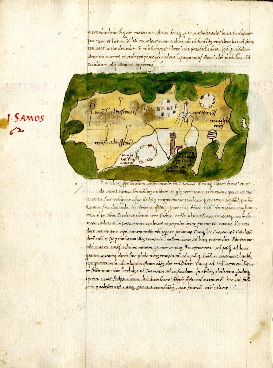
His account of Samos, for example, connects the topography of the island to ancient sites, including the Heraion (Fig. 4), the sanctuary of Hera near modern-day Pythagorion, as well as to celebrated figures such as Pythagoras, the Sibylla (prophetess) Fyrso, and the Samian tyrant Polycrates. He also records more recent historical events, including the arrival of refugees from Asia Minor during the raids of Tamerlane in the late fourteenth century. Geography and historical memory thus become intertwined, giving Samos a significance that extends beyond its geographical location.
The isolario thus operated at two scales: it described particular islands, sites, and monuments while bringing them together within an illustrated account of the Aegean, presented as a coherent historical space. Readers could move between individual sites and the archipelago, even when its islands appeared on different folios of the codex.[8] Topography supplied the tools for describing the particular, while cosmography placed those particulars within a larger spatial order. The two perspectives were complementary: the archipelago took shape through its constituent parts, while each part acquired broader significance through its place within the imagined whole.
Nautical and portolan charts offered another means of relating individual islands to the surrounding sea. Representing coastlines, bearings, routes, and navigational relationships, these charts enabled sailors to negotiate the sea in real time.[9] An important parallel to European traditions was the Ottoman cartography of Piri Reis (c. 1470–1554), whose Kitab-ı Bahriye (Book of Navigation), compiled in the early sixteenth century, combined coastal charts with detailed sailing directions for the Mediterranean. Its representations of the Aegean islands brought together navigational knowledge, descriptions of harbors and coastlines, and information concerning settlements and local conditions. Circulating in manuscript copies well into the eighteenth century, the work offers another perspective on how the archipelago could be organized and understood through the combined practices of mapping and navigation.[10]
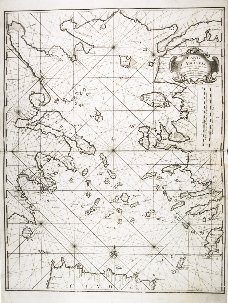
The navigational principles of early portolans found a different expression in later European hydrographic traditions, where the representation of maritime space increasingly served the practical demands of navigation. A large-format nautical atlas of the Mediterranean published in Marseille by François Berthelot around 1720–1730 offers a remarkable example of early eighteenth-century French hydrography.[11] The final chart, Carte de l’Archipel, focuses on the Aegean Sea, providing detailed coverage of the Greek archipelago and the western coast of Asia Minor (Fig. 5). This practical approach to navigation differed from the historical and imaginative descriptions assembled in an isolario, such as that of Buondelmonti. Their comparison reveals different ways of organizing geographical knowledge; together, these forms of representation connected the islands through memory and movement, contributing to an increasingly coherent conception of the Aegean as an archipelago.
Travel, Antiquarian Knowledge, and Political Geography in the Eighteenth Century
The European colonial expeditions of the late fifteenth and sixteenth centuries expanded geographical horizons without diminishing the political, commercial, and intellectual significance of the Mediterranean. While histories of early modern global exchange have often privileged the Atlantic and the “New World,” the Mediterranean remained a vital maritime space, attracting growing interest as a field of antiquarian inquiry, scientific exploration, and geographical knowledge.[12] Travel accounts allow us to trace how European understandings of the Aegean evolved, linking early modern cartographic traditions to the botanical, antiquarian, and proto-ethnographic approaches of the eighteenth century.
Eighteenth-century travel literature brought inherited cosmographic, antiquarian, and navigational practices into new descriptive frameworks, incorporating natural history, the study of local societies, and questions of political geography. The Relation d’un voyage du Levant, fait par ordre du Roy of Joseph Pitton de Tournefort (1656–1708), published posthumously in 1717, provides a revealing example.[13] Commissioned by the French crown, Tournefort traveled through the eastern Mediterranean between 1700 and 1702, combining botanical observations, geographical descriptions, antiquarian research, and accounts of local societies and economies. His treatment of Samos illustrates how these different forms of knowledge converged.[14] He begins by locating the island through compass bearings, maritime distances, and references to ancient geographers before developing a detailed narrative that interweaves personal observations with classical testimony. His account ranges from the island’s celebrated muscat grapes and the protection afforded by Tigani’s harbor against the sirocco to the Eupalinian aqueduct and the antiquities of the Heraion. Throughout his account, Tournefort repeatedly invokes Herodotus, Strabo, and Pausanias, connecting the contemporary landscape to its ancient geographical and historical representations.
Tournefort thus transforms Samos into an archive in which classical texts, material remains, local practices, and personal observation converge.[15] His work offers a useful point of comparison with earlier portolan and isolario representations, revealing continuities and changes in the organization of geographical knowledge. Although critical of seventeenth-century Venetian cartographers for their inaccuracies and lack of scientific precision, Tournefort remained indebted to the cartographic traditions he sought to supersede. His account also broadens the scope of geographical inquiry: descriptions of local customs and religious practices complement antiquarian and natural-historical observations, reflecting a growing political and geostrategic interest in the societies inhabiting the Aegean. Ottoman travel literature offers another perspective on these practices. In his seventeenth-century Seyahatname (Book of Travels), Evliya Çelebi likewise described the Aegean islands through their settlements, populations, religious institutions, and historical traditions, situating them within the political and maritime geography of the Ottoman Empire.[16] Travel literature therefore provides a bridge between early maritime representations and eighteenth-century efforts to understand the archipelago as both a historical landscape and a space of contemporary political significance.
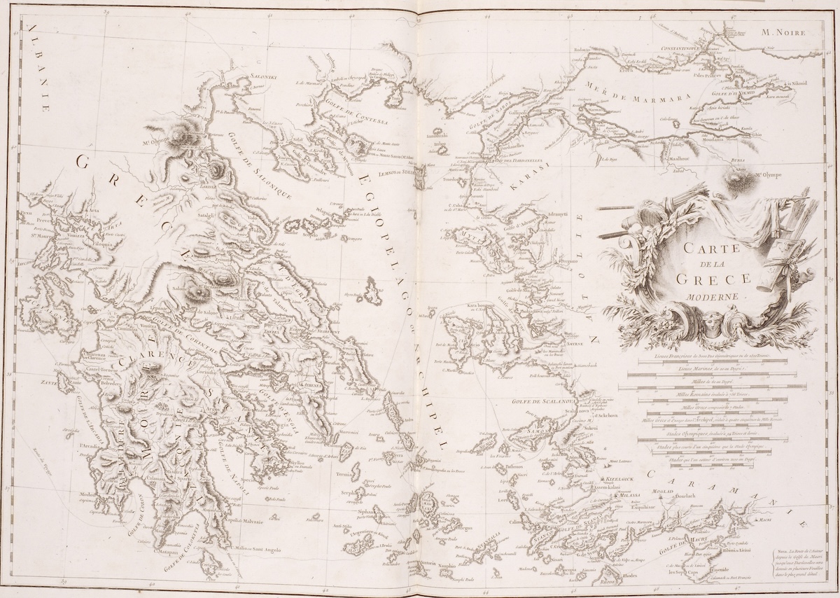
The political geography of the Aegean changed unevenly as Ottoman authority expanded and conflicts over islands and maritime routes continued. The Venetian-Ottoman rivalry gave way to increasingly consolidated Ottoman control, integrating the islands into an Ottoman Mediterranean maritime world. Within this changing environment, maps and travel accounts registered new perspectives on the region. Western visitors increasingly described the Aegean as a space inhabited, navigated, traded through, and defended by its populations. The Carte de la Grèce moderne (1782) included in the first volume of Choiseul-Gouffier’s Voyage pittoresque de la Grèce places mainland Greece, the Aegean islands, and the coast of Asia Minor within a single spatial frame (Fig. 6). Far from depicting a nation already politically unified, the map presents Greece as a coherent geographical space, bringing together the mainland and Aegean islands decades before the establishment of an independent Greek state.
Local knowledge, commercial networks, maritime skill, and ways of dealing with piracy and warfare constituted another form of mastery over the archipelago. De Certeau’s distinction between tactics and strategies helps identify both the importance and the limits of this knowledge. What appears tactical—small-scale practices of navigation, exchange, adaptation, and survival—could accumulate and collectively produce an intimate command of the maritime environment. Although those who moved repeatedly between the islands did not necessarily possess the detached strategic vision of the cosmographer, they acquired embodied and practical knowledge of the Aegean. Yet within the layered governance of the archipelago, familiarity with routes and climatic conditions did not necessarily confer authority over ports or control over access to them.
Richard Chandler’s account of his travels in the 1760s reveals how these forms of knowledge and authority intersected along the routes connecting the archipelago to the Anatolian mainland. Traveling from Mylasa toward Miletus, Chandler recalled that he and his companions “were led unexpectedly to the discovery of Myus” when an unnamed guide diverted them from the road and conducted them to a set of ruins.[17] At Iasos, the relationship between antiquarian interpretation and local knowledge became more openly contentious as a Greek priest asked him to move from an inscribed stone on which he had seated himself. Chandler had recognized an ancient text but overlooked its use as an altar. Although he dismissed the priest as “wretchedly ignorant,” his own account reveals the limits of antiquarian understanding in a place where ancient remains also belonged to contemporary religious life.[18] Access to the castle likewise required a written order from the Ottoman aga, a condition enforced by a Greek resident. On Chios, meanwhile, Chandler paid to copy three inscribed marbles transported from Iasos, encountering evidence of ancient geography through contemporary maritime circulation. Knowledge of routes, religious practice, political jurisdiction, and antiquarian interpretation thus shaped access to places and objects, giving their practitioners different, sometimes conflicting claims to authority.
The National Archipelago
By the late eighteenth century, the links between space, memory, and agency were acquiring new political meanings. Cartography offered a means of connecting places through a shared understanding of the past and imagining how they might belong together under a different political order. The Charta of Greece, published by Rigas Velestinlis in Vienna in 1796–1797, brought these possibilities into focus.[19] Across twelve sheets, ancient and modern place-names, inset plans, and representations of coins connected individual sites to a geographical field encompassing the Aegean and extending across the Balkans and into Asia Minor. The islands formed part of a larger historical world whose connections acquired renewed political significance within the democratic, pan-Balkan, and multi-ethnic Greek state envisioned by Rigas. This expansive geography exceeded the boundaries of the later independent Greek state, preserving possibilities for political association that cannot be reduced to that subsequent territorial settlement.
The Greek Revolution of 1821 recast these spatial and historical connections in a new national and revolutionary framework. The islands could be represented and understood as components of a newly imagined Greek national space. Independence, however, exposed a discrepancy between the geography of revolutionary participation and the borders of the new state. Islands could occupy a prominent place in accounts of the Revolution while remaining outside independent Greece. This discrepancy informs the visual history commissioned by Ioannis Makriyannis in the 1830s.
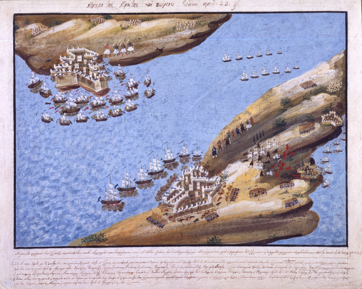
The image depicting the Battles of Crete and Samos, produced between 1836 and 1839, offers a revealing example of how the Greek Revolution was represented beyond the borders of the new state (Fig. 7). Its geographical inaccuracy is central to its meaning: Crete and Samos, separated by a considerable distance, are brought together within a single composition, with Samos in the upper left, Crete in the lower right, and ships filling the intervening sea. Rather than reproducing geographical proximity, the image brings two islands together through their shared place in the history and memory of the Revolution. The circumstances of its commission help explain this reorganization of geographical space.
The painting formed part of a series commissioned by the Greek revolutionary fighter Ioannis Makriyannis to create a visual account of the struggle for independence alongside his written Memoirs. Working with the painter Dimitrios Zographos, Makriyannis directed the representation of battles and participants, particularly those associated with mainland Greece, where he had fought.[20] The choice to depict Crete and Samos together nevertheless extends this account beyond the places most closely associated with his own experience. Together, the two islands function as a synecdoche for a wider maritime theater of revolutionary struggle: their particular histories stand for a broader collective experience, while the Aegean becomes part of an imagined Greek national space that exceeds the territorial limits of the emerging state.
The numbered caption accompanying the image reinforces this interpretation by presenting the islands through the experiences of their inhabitants. Samos, for instance, is described through its “castle and townships and battlefields,” the Ottoman attacks it endured, the Greek ships that came to its aid, and the courage and sacrifice of its defenders. The caption also names the island’s commanders, including Lykourgos, Stamatis, Lachanas, and Manolis. Crete is similarly associated with its fortified places, settlements, battles, and commanders, as well as the support provided by Greek forces on land and sea. In both cases, the accompanying text transforms the islands from geographical locations into sites of collective struggle, preserving their revolutionary histories as part of a shared national memory.
The political histories of Crete and Samos lend further weight to this representation. Samos had enjoyed a degree of self-government under Ottoman rule and joined the Revolution in 1821. With support from the Greek fleet, the island resisted repeated Ottoman attacks, while Greek naval victories, such as the battle of Gerontas in 1824, helped prevent its recapture. Crete, too, experienced repeated uprisings and severe repression during the revolutionary years. Yet neither island became part of the Greek state established under the 1830 Protocol of Independence.
This divergence gives the composition its political force. The painting does not merely record an existing political reality; it imagines a different one. By compressing the physical distance between Crete and Samos within a single pictorial field, it establishes a relationship that political geography had not yet secured. The two islands thus become fragments of an imagined territorial whole and, simultaneously, a projection of what that whole might become.
Seeing the Aegean as One’s Own
These national representations drew upon earlier geographical and historical understandings of the archipelago, reconfiguring inherited cartographic conventions and historical associations to articulate new claims of political belonging. The movement from Renaissance cosmography to nineteenth-century nationalism reveals changing relationships between scale, memory, and sovereignty. The cosmographer begins with the whole, transforming scattered islands into an ordered archipelago. The antiquarian turns to particular sites through which the historical meaning of that whole can be established. The local sailor experiences the space from within, connecting its fragments through movement and practice. Finally, the revolutionary reverses the process: a particular island, battle, or community becomes a fragment capable of standing for the imagined whole of the nation. The image of Crete and Samos makes this reversal visible. To see Samos and Crete is to imagine the archipelago; to imagine the archipelago is to imagine a Greek national space.
The local and cosmographic perspectives remain mutually constitutive: the whole becomes meaningful through its fragments, while the fragments acquire political significance through their place within an imagined whole. Historical memory provides the connection between them: references to antiquity establish a common past; navigation and commerce establish connections in lived space; revolutionary warfare turns those connections into a shared history of struggle; and nationalism transforms them into claims about a common future.
The history of mapping the Aegean archipelago is thus a history of learning to see it as one’s own. Across its successive representations, European efforts to comprehend and claim a complex maritime world gradually intersected with Greek projects of defining that world through historical memory, lived experience, and political imagination. Maps and images reveal their power to do more than show where the islands were. They could suggest how the islands belonged to a historical whole and, crucially, where they might belong in the future.
Maria Georgopoulou is the Director of the Gennadius Library of the American School of Classical Studies in Athens, Greece
Acknowledgments: I would like to thank Demetra Vogiatzaki for inviting me to participate in this issue and for her editorial contributions to the discussion of eighteenth-century material.
[1] André Thevet, Cosmographie de Levant, ed. Frank Lestringant (Droz, 1985); Frank Lestringant, André Thevet, cosmographe des derniers Valois (Droz, 1991). The most famous work of Thevet is a book titled Les singularitez de la France Antarctique published in 1557 after his return from the Americas. On the Grand Insulaire, see also F. W. Hasluck, “Thevet’s Grand Insulaire and His Travels in the Levant,” Annual of the British School at Athens 20 (1913–14), 59–69. The maps of the Aegean islands would have constituted the second volume of a comprehensive book of islands that contained those of the New World in volume one. A manuscript is held in the Bibliothèque nationale de France in Paris (MS Français 15452–15453), whereas the maps held at the Gennadius Library belong to a proof copy in an album bought by Joannes Gennadius (shelfmark GT 229q). The image discussed here appears on page 18f.
[2] Michael Loy, “Early Modern Travellers in the Aegean: Routes and Networks,” Annual of the British School at Athens 114 (2019): 369–98, esp. 392.
[3] Entitled in Greek Χάρτα ναυτική συμμαζωμένη του β΄ μέρους της Μεσογυίου θαλάσσης από Μάλτας, έως Αλεξανδρέτας, και μέχρι Κωνσταντινουπόλεως [Nautical Map of the Second Part of the Mediterranean Sea, from Malta to Alexandretta and Constantinople], the chart measures 66 × 97.5 cm and includes an extensive legend detailing its sources and scientific parameters. Gennadius Library, shelfmark GT 311–312q.
[4] In this context, see also George Tolias, “Military Mapping, Philhellenic Geography, and the Making of Greece, 1811–1827,” The Historical Review/La Revue Historique, 19, no. 1 (2022): 143–66.
[5] Michel de Certeau, The Practice of Everyday Life, trans. Steven Rendall (University of California Press, 1984), 29–42.
[6] George Tolias, “The Politics of the Isolario: Maritime Cosmography and Overseas Expansion During the Renaissance,” The Historical Review/La Revue Historique 9, no. 1 (2013): 27–52.
[7] Hilary Louise Turner, “Christopher Buondelmonti: Adventurer, Explorer and Cartographer,” in Géographie du monde au Moyen Âge et à la Renaissance, ed. Monique Pelletier (Éditions du CTHS, 1989), 207–16.
[8] Tolias, “The Politics of the Isolario”; George Tolias, “Isolarii, Fifteenth to Seventeenth Century,” in The History of Cartography, vol. 3: Cartography in the European Renaissance, ed. David Woodward (University of Chicago Press, 2007), 263–84; Frank Lestringant, Le livre des îles: Atlas et récits insulaires de la Genèse à Jules Verne (Droz, 2002).
[9] Tony Campbell, “Portolan Charts from the Late Thirteenth Century to 1500,” in The History of Cartography, vol. 1, Cartography in Prehistoric, Ancient, and Medieval Europe and the Mediterranean, ed. J. B. Harley and David Woodward (University of Chicago Press, 1987), 371–463; George Tolias, The Greek Portolan Charts, 15th–17th Centuries: A Contribution to the Mediterranean Cartography of the Modern Period, trans. Geoffrey Cox and John Solman (Olkos, 1999).
[10] Svat Soucek, “Islamic Charting in the Mediterranean,” in The History of Cartography, vol. 2, bk. 1, Cartography in the Traditional Islamic and South Asian Societies, ed. J. B. Harley and David Woodward (University of Chicago Press, 1992), 263–92.
[11] The atlas opens with the Nouvelle carte de partie des cotes de terre Ferme et isles situées sur l’océan, illustrating the approaches to the Mediterranean from the Atlantic, including the coasts of Portugal, Spain, France, the British Isles, and northwest Africa, together with the Azores, Madeira, and the Canary Islands. Two adjoining charts, entitled Carte des Cotes de la Mediterranée, provide a detailed survey of the western and eastern Mediterranean.
[12] Molly Greene, Catholic Pirates and Greek Merchants: A Maritime History of the Early Modern Mediterranean (Princeton University Press, 2010).
[13] Joseph Pitton de Tournefort, Relation d’un voyage du Levant, fait par ordre du Roy, 3 vols. (Lyon: Anisson et Posuel, 1717); Émile Kolodny, “Tournefort, un voyageur provençal dans l’Archipel grec au début du XVIIIe siècle,” Provence historique 47, no. 190 (1997): 637–45.
[14] Tournefort, Relation d’un voyage du Levant, 2:101–40.
[15] Frank Lestringant, “L’herbier des îles, ou le ‘Voyage du Levant’ de Joseph Pitton de Tournefort (1717),” Littérales 7 (1990): 55–56.
[16] Suraiya Faroqhi, “Istanbul and Crete in the Mid-1600s: Evliya Çelebi’s Discourse on Orthodox Christians,” Medieval History Journal 22, no. 2 (2019): 321–42.
[17] Richard Chandler, Travels in Asia Minor; or, An Account of a Tour Made at the Expense of the Society of Dilettanti (Oxford: Clarendon Press, 1775), 171. Choiseul-Gouffier subsequently identified the ruins as those of Heracleia at Latmos. See Marie-Gabriel-Florent-Auguste de Choiseul-Gouffier, Voyage pittoresque de la Grèce, vol. 1 (Paris: J.-J. Blaise, 1782), 176.
[18] Chandler, Travels in Asia Minor, 182–83.
[19] George Tolias, “Antiquarianism, Patriotism and Empire: Transfer of the Cartography of the Travels of Anacharsis the Younger, 1788–1811,” e-Perimetron 3, no. 3 (2008): 101–19; Evangelos Livieratos, “On the Cartography of Rigas Charta,” e-Perimetron, 3, no. 3 (2008): 120–45; and George Tolias, Challenged Territories: Cartographies of Greece and the Levant during the Ottoman Era (Isis Press, 2010).
[20] Maria Georgopoulou, ed., Ioannis Makriyannis: Vital Expression, exh. cat. (Gennadius Library and Kapon Editions, 2018), 160–63. See also Ioannis Makriyannis, The Memoirs of General Makriyannis, 1797–1864, ed. and trans. H. A. Lidderdale (Oxford University Press, 1966).
Cite this article as: Maria Georgopoulou, “The Aegean Archipelago: Cartography, Historical Memory, and National Identity,” Journal18, Issue 22 Archipelago (Fall 2026), https://www.journal18.org/8414.
License: CC BY-NC
Journal18 is published under a Creative Commons CC BY-NC International 4.0 license. Use of any content published in Journal18 must be for non-commercial purposes and appropriate credit must be given to the author of the content. Details for appropriate citation appear above.
