Íris Kantor
Milena Natividade da Cruz
In April 1754, the French literary gazette Mercure de France announced the publication of five large mural maps made by the geographers Jean Janvier and Sébastien-G. Longchamps, comprising a mappa mundi and additional large maps dedicated to the four continents: America, Asia, Africa, and Europe, all engraved by Gobert-Denis Chambon.[1] These maps are richly ornamented by illustrations and texts addressing historical, political, and economic events related to European activities in all four continents, informed by the editorial agenda of Abbé Raynal (1713-1796). This short essay explores how cartography interacted with visual and textual inscriptions to produce meaning in the mural maps of Janvier and Longchamps.[2] Here, we pay special attention to the mural map of Africa (Fig. 1).
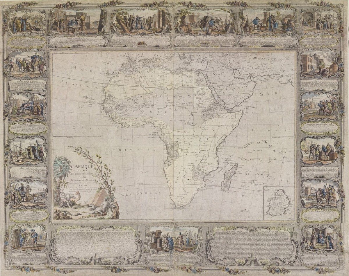
Generally speaking, scholars tend to employ two ways of understanding European cartography of Africa in this period: firstly, focusing on the development of cartographic techniques and the history of surveying;[3] and secondly, attending to their role in Europe’s imperial project, either as a site of symbolic projection or as an instrument used to govern populations and manage colonial resources.[4] Building on these approaches, we consider how French cartographic imagery produced in the first half of the eighteenth century participated in the racialization of African peoples. French geography played a key role, for example, in Immanuel Kant’s Of the Different Races of Human Beings (1775). Kant used the cartographer Philippe Buache de la Neuville’s (1700-1773) concept of geophysical platôs to spatialize his theory of racial hierarchization. [5] In this article, however, we focus exclusively on how a handful of cartographic objects enacted racial ways of thinking. France is a privileged field of observation in this regard due to its central role producing and disseminating Enlightenment epistemologies. The Janvier and Longchamps mural map of the African continent, in particular, serves as a rich carto-bibliographic corpus that allows us to begin to confront, distinguish, and evaluate the different meanings attached to cartographic imagery in this context.[6]
In the first instance, we could consider how the map encoded a relationship between skin color and the peoples of each continent. In the mural map of Africa, the cartouches adopt a self-consciously “modern” understanding of Black skin, at least according to the perspective of European sources at the time. The two mapmakers critique what they regarded as an antiquated notion about how darker skin color results from sunstroke:
Most people in Africa are noirs; others are heavily tanned. It cannot be denied that the burning of the sun contributed to making them such, but that is not the only cause, because Americans who are in the same climate do not have such a noir complexion, and “nègres” who are born in cold countries keep the same hue.[7]
While this assertion might initially appear to de-couple skin color and geographical location, the mapmakers ultimately insisted upon the distinctness of the African continent’s climatic conditions—a fundamental theme for Enlightenment thought—and the skin colors of its peoples.[8] Janvier and Longchamps were not the first to question the role of climate in determining the skin color of populations below the Equator; since at least the sixteenth century, travel reports had been calling this hypothesis into question.[9] However, in the eighteenth century the nature of Black skin color had become a topic of intensifying anatomical and physiological study. For the French naturalist Pierre Louis Moreau de Maupertuis (1698-1759), for example, the phenomenon of albinism in Black people proved that Adam and Eve must have been of white complexion.[10] Tellingly, only the map of Europe omits a discussion of the skin color of its inhabitants. In doing so, the Janvier and Longchamps collection of mural maps implicitly stage European whiteness as a normative skin color from which all other geographies and all other skin colors deviate.
Among the questions at stake in ascendant debates about human variety was whether the races constitute fundamentally different species with distinct origins, or whether all races descended from the same shared origin—positions that would later be called ‘polygenesis’ (multiple origins) and ‘monogenesis’ (single origin). Janvier and Longchamps invoke an explicitly Biblical genealogy associated with monogenesis, identifying the population of Africa as the descendants of Ham in their map. The “curse of Ham” recounted in the Book of Genesis was a punishment inflicted by Noah onto Ham, condemning his son Canaan to perpetual servitude—a widely-referenced parable for the claim that people with melanated skin tones were (like Canaan) the subjects of divine punishment destined for subjugation.[11] In the map’s textual description of the founding of the Kingdom of Egypt, it’s noted that Noah’s curse fell specifically on Ham’s son Canaan. But Janvier and Longchamps’s text does not link skin color, servitude, and the “curse of Ham.” On the contrary, their discussion of enslavement and servitude in the Africa map is framed in decidedly mercantile (rather than Biblical) language, with enslaved people listed alongside goods like ivory and gold.
A similar perspective can be found twenty-six years earlier in the Nouvelle relation de l’Afrique occidental (1728) of Jean-Baptiste Labat. For Labat, a Dominican priest and plantation owner in Martinique, the myth of Ham didn’t prove that skin color was the result of a malediction. Yet it did, in his view, justify the enslavement of Africans.[12] Related questions about shared origins and phenotypes likewise appeared in Montesquieu’s best-seller L’Esprit des lois (1748), which popularized the theory that hot climates produced a natural tendency for servitude and, in doing so, reaffirmed for a broader audience the key role that geography played in the classification of humanity.[13]
In other contemporaneous mural maps, such as Jean-Baptiste Nolin’s L’Afrique dressée sur les relations les plus récentes et rectifiées sur les dernières observations (1740) and Jean-Baptiste Louis Clouet’s L’Afrique divisée en ses principales états (1776), illustrations and inscriptions dedicated to the religious conversion of Nubia, Abyssinia, and Congo aligned enslavement with the project of Christian missionaries.[14] Converting kidnapped Africans to Christianity served as a potential justification for their enslavement according to some accounts. While Janvier and Longchamps invoke Biblical exegesis repeatedly, they do not appeal to it nor to the mission of Christian conversion in order to defend chattel slavery. Yet we could not say they critique it, either. As noted earlier, the map of Africa lists enslaved people among the material goods available in African ports, especially in “Nigritie” and Guinea. In this sense, slavery does not represent a means of religious conversion; it instead converts peoples of Africa into desired commodities.
The naming of regions serves as another important register in which we can think about how the map articulates a relationship between geography and racial difference. Toponyms reflect the association that European maps make between African territories and the phenotype of their inhabitants. The “Nigritie” region, whose etymology given by Janvier and Longchamps is “so called because its inhabitants are noir,” was debated by renowned cabinet geographers. Guillaume Delisle in his Introduction à la géographie (1746) and Jean-Baptiste Bourguignon d’Anville in the Afrique map (1749) both disagreed with the definition proposed in Janvier and Longchamps’s mural map, since the region’s name originates from the Niger river.[15] Janvier and Longchamps, then, were being polemical when insisting that the name of the place stemmed from the racial identity of its inhabitants, again forging a link between spatial difference and racial difference—a difference that was also a hierarchy privileging a European vantage point. The language used to describe the African continent in the mural map exemplified how European cartography, more broadly speaking, presented African spaces as a prospective source of forced labor for colonized territories in the Americas.[16] Thus, the map assigned toponyms that were foreign to native peoples and that took on meaning within a system of racial classification which reified and naturalized European whiteness. Naming a space according to the presumed skin color of its peoples, as a strategy of cartographic knowledge production, was closely aligned with European efforts to enslave such peoples. Janvier and Longchamps treated the slave trade as the result of an internal market that already existed on the African continent, which effectively minimized the role of European slave traffickers in actively building such a network. Especially in “Nigritie,” trade in leather, ivory, and powdered gold coincided with the traffic of enslaved women and children from neighboring communities.
On the America mural map, enslaved Africans are repeatedly called “nègres,” a derogative historical term that is now regarded as a violently racist slur.[17] The inscription argues that the mestizo population of the colonies resulted from the relationship between Europeans and Indigenous peoples: “[America] is divided between Northern and Southern, united by the Isthmus of Panama. These two large parts are populated by four types of inhabitants: 1st the Europeans, who settled there; 2nd Americans, or natives of that country; 3rd the Mestizos who are born of a European and an American, or of an American and an American; 4th the ‘Nègres’ who are transported from Africa.”[18] The lack of reference to Black mestizos perhaps reflects the repercussions of the 1724 edition of Code Noir, which prohibited marriages between white and Black subjects from Louisiana.[19] The nomenclature supplies a taxonomy that binds together geographical origin, skin tone, and status. It is yet another example of how mural maps portrayed Africa in light of prospective French economic gain and an emergent idea of skin color as the ultimate signifier of racial identity.
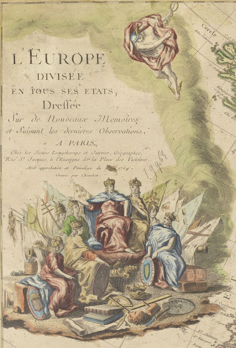
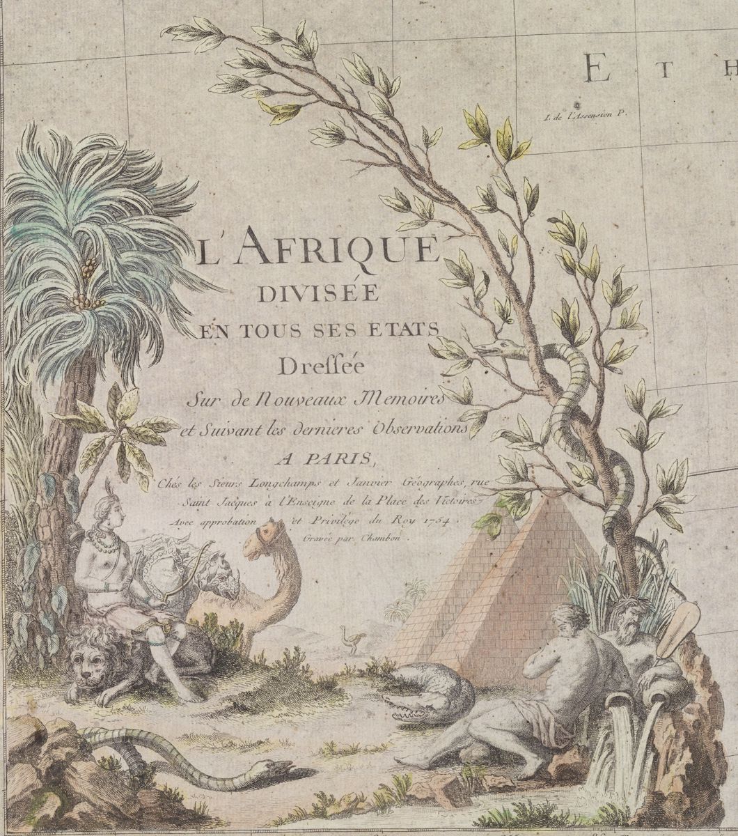
In the cartouche that titles the map (Fig. 2), the allegorical figure of Africa is portrayed as a young white woman, contradicting artistic conventions of the time.[20] Adorned with necklaces and feathers in her straight hair, with her chest and legs left bare, she holds a bow and arrow. At the young woman’s feet are a lion and a serpent. In contrast, the allegory on the map of Europe (Fig. 3) is composed of a group of women in long dresses that cover their entire bodies. Above their heads are crowns, and under their feet one finds books, maps, compasses, and a terrestrial globe. In subsequent editions of the map of Africa, produced solely by Janvier, there is a reduction in the symbolic elements that make up the allegories of each continent (Figs. 4 and 5).[21] The association of allegories with the spaces they represent further articulates a hierarchy between the continents, in which material and symbolic asymmetries govern the mural map’s portrayal of different national, racial, and ethnic identities.[22]
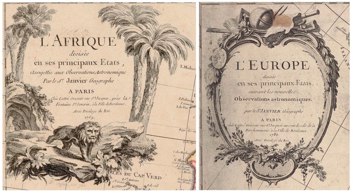
RIGHT: Fig. 5. Jean Denis Janvier, L’Europe divisée en ses principaux Etats assujettie aux Observations Astronomique (Paris: Chez Jean Lattré, 1769 ; reprint of 1760 original). Engraving, 65 x 48 cm. Image in the public domain. Image source: gallica.bnf.fr / Bibliothèque nationale de France.
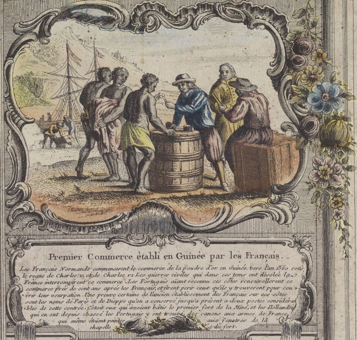
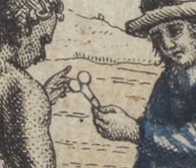
In the ornament titled “Premier commerce établi en Guinée par les français [sic.],” a similar asymmetry can be found. A French merchant handing scissors to an African buyer is seen in the foreground (Figs. 6 and 7). According to Nicolas Villault’s Relation (1669), one of the likely sources of Janvier and Longchamps, the peoples of “Grand-Sestre” dominated the kind of iron metallurgy capable of repairing French scissors.[23] However, African technologies are not acknowledged in the image nor in the ornamental text. Garments signal a difference between African and European cultures, exemplified in the contrast between nudity and clothing (details found in Figs. 6 and 7). In other ornaments, political and cultural events are described in relation to Mediterranean Africa, whereas commercial activities refer to “Black” Africa, reducing the complexity and political dynamism of this portion of the continent.[24]
On wall maps of Africa, Asia, and America the historical developments depicted in the ornaments culminate in a description of French settlements on each continent. The last caption of the mural map, finally, delimits which portion of the coast of Africa comprises the “Compagnie de Guinée.” In contrast with mural maps made by contemporary geographers, such as Jean Baptiste Nolin (1740) or Jean Baptiste Louis Clouet (1776), only in the Janvier and Longchamps series is the state of the French presence on the continents foregrounded in the ornamental narratives. It is worth noting that Janvier and Longchamps produced the wall maps series after the Madrid Treatise (1750), when the Spanish crown disrupted the “asiento de los negros,” a monopoly contract that had been part of the Peace of Utrecht (1713-1715) with England. This raises important questions we have discussed elsewhere about which interests presided over the production of the series, especially if the French trading companies (like their Dutch counterparts) played a significant role.[25] The different symbolic languages that constitute the mural maps of Janvier and Longchamps disclose much about how the producers and consumers of French maps understood their relationship to the continents of the world. Close study of their inscriptions, toponyms, and iconography reveals just how multi-faceted and important mural maps were in the European construction of racial difference. As histories of race in the Enlightenment have shown us, the process of constructing whiteness as a norm was tortuous and long-lasting, in which racial others were constituted through forms of negation, cultural degradation, and subalternity.[26] Cartography had an unexpected, yet central, role to play.
Íris Kantor is Professor of History at the Universidade de São Paulo, where she also oversees the Laboratório de Estudos de Cartografia História USP
Milena Natividade da Cruz is a Masters student in Social History and a researcher at the Laboratório de Estudos de Cartografia História USP
Acknowledgments: We are grateful to Stephanie O’Rourke and Susannah Evelyn Blair for their insightful feedback on drafts of this essay.
[1] Mercure de France (April 1754), 162-168; Ronald Vere Tooley, Tooley’s Dictionary of Mapmakers (Riverside, CT: Early World Press, 2001); Franz Reitinger, “Voltaire’s Valet: The Career of Sebastian G. Longchamps from Servant to Map Publisher,” Sjuttonhundratal (2010), 74-96; Franz Reitinger, “Wall Maps with Historiated Borders: A New Map Type in the Eighteenth Century,” IMCoS Journal, Quendon, Essex, 141 (2015), 34-46.
[2] Louis Marin, “La ville dans sa carte et son portrait,” in Daniel Arasse, ed., De la répresentation (Paris: Gallimard, 1994), 204–218.
[3] Jaime Cortesão, “África nostra (I): descobriram os franceses, antes de nós, a Guiné, o Cabo da Boa Esperança e o caminho marítimo para a Índia?,” Boletim da Agência Geral das Colónias (1925), 90-106; Avelino T. Mota, Cartografia antiga da África Central e a travessia entre Angola e Moçambique (1500-1860) (Moçambique: Lourenco Marques, 1964).
[4] Isabelle Surun, “Le blanc de la carte, matrice de nouvelles représentations des espaces africains,” in Isabelle Laboulais-Lesage, ed., Combler les blancs de la carte: modalités et enjeux de la construction des savoirs géographiques (XVIIe-XXe siècle) (Strasbourg : Presses universitaires de Strasbourg, 2004), 117-144; Helene Blais, “Coloniser l’espace: territoires, identités, spatialité,” Genèses 74:1 (2009), 145-159; Júnia F. Furtado, “Evolving Ideas: J.B. D’Anville’s Maps of Southern Africa, 1725–1749,” Imago mundi 69:2 (2017), 202-215; Francesc Relaño, The Shaping of Africa: Cosmographic Discourse and Cartographic Science in Late Medieval and Early Modern Europe (Aldershot: Ashgate, 2002).
[5] Immanuel Kant, Of the Different Races of Human Beings, 1775. Translated and noted by Alexandre Hahn, Kant e-Prints 5 (2010), 26.
[6] John Brian Harley, La nueva naturaleza de los mapas: ensayos sobre la historia de la cartografía (México: Fondo de Cultura Económica, 2005).
[7] “La plupart des Peuples de l’Afrique sont noirs; les autres sont fort basanés. On ne peut nier que l’ardeur du soleil n’ait contribué a [sic.] les rendre tels ; mais ce n’en est pas la seule cause, puisque les Americains qui sont dans le mème [sic.] climat n’ont pas le téint si noir, et que les Nègres qui naissent dans le païs froids conservent le même téint.” Jean Janvier and Sebastien-G. Longchamps, “Idée Historique de l’Afrique Ancienne,” L’Afrique divisée en tous ses États… , (Paris, 1754). This article avoids employing the word “nègre” unless it is an important part of a historical quote or title, in keeping with recently published scholarship in the field. For a discussion of this see Lafont, L’Art et la race, 35-36. The reclaiming of this term within the context of twentieth-century négritude has its own complex history. See Ligia Fonseca Ferreira, “Negritude”, “negridade”, “negrícia”: história e sentidos de três conceitos viajantes, Via Atlântica, 9 (2006), 163-183; Kabenguele Munanga, Negritude: usos e sentidos (Ática, 1986).
[8] Lorelay Kury, “La nature de la nation: le climat et les gens du Brésil (1780-1836),” Annales Historiques de la Révolution Française 3 (2011), 136.
[9] Duarte Lopes and Filippo Pigafetta, Relação do Reino do Congo e das terras circunvizinhas (Lisboa: Agência Geral do Ultramar, 1951), 29.
[10] Andrew S. Curran, The Anatomy of Blackness: Science and Slavery in an Age of Enlightenment (Baltimore: John Hopkins University Press, 2011), 94.
[11] The story of Noah and Ham was subsequently used to defend the enslavement of Black peoples, perhaps most famously invoked by plantation owners in the Antebellum southern United States. On the plasticity of the Ham myth, see: Alphonse Quentun, Eglises chrétiennes et la traite atlantique du XVe au XIXe siècle [1993] (Paris: Karthala, 2008), 27-35; Carlos Almeida, “‘Habitantes desta negra Etiópia, descendentes de Ham’: a maldição de Ham na literatura missionária sobre a região centro-ocidental do continente africano (sécs. XVI-XVII),” Estudos Ibero-Americanos 44:3 (2018), 409-420.
[12] Jean Baptiste-Labat, Nouvelle relation de l’Afrique occidental, 4 vols. (Paris: Pierre-François Giffart, 1728), 2: 252-271; Alberto da Costa e Silva, A manilha e o libambo (Rio de Janeiro: Nova Fronteira, 2002), 850; Curran, The Anatomy of Blackness, 78.
[13] Pierre Bourdieu, “Le Nord et le Midi: contribution à une analyse de l’effet Montesquieu,” Actes de la recherche en sciences sociales 35 (1980), 22.
[14] Jean-Baptiste Nolin II, L’Afrique dressée sur les relations les plus récentes et rectifiées… (Paris,1740): https://gallica.bnf.fr/ark:/12148/btv1b77590957; Jean-Baptiste-Louis Clouet, Carte d’Afrique divisée en ses principaux Etats… (Paris, 1776): https://gallica.bnf.fr/ark:/12148/btv1b550131582
[15] “Ainsi apellé parce que les habitans en sont noirs.” “Idée Historique de l’Afrique Moderne,” Jean Janvier and Sebastien-G. Longchamps, L’Afrique divisée en tous ses États…, engraved by Gobert-Denis Chambon (Paris, 1754).
[16] Maurício Waldmann, “Cartografia de África: toponímia, africanidade e imaginário,” Revista Equador 3:1 (UFPI), 29.
[17] See note 7 for more on the history and usage of this term.
[18] “On la divise en Septentrionale et Meridionale jointes par l’Isthme de Panama. Ces deux grandes Parties sont peuplées par quarte sortes d’habitans. 1º les Europeans qui si sont établis. 2º les Americains ou naturels du Païs. 3º les Metis qui sont nés d’un European et d’une Americaine, ou d’un Americain et d’une Europeane. 4º et les Nègres que l’on y transporte de l’Afrique.” “Idée de l’Etat Actuel de L’Amerique,” Jean Janvier and Sébastien-G. Longchamps, L’Amerique divisée en tous ses Pays et États…, (Paris, 1754).
[19] CODE NOIR, Artigo VI, 1724. See: Marcel Dorigny and Bernard Gainot, Atlas das escravidões: da Antiguidade até nossos dias (Editora Vozes, 2017). See also Louis Sala-Molins, Le Code noir ou le calvaire de Canaan (Paris: Presses Universitaires de France, 1987).
[20] Jean Devisse, Michel Mollat, and Hugh Honour, eds., L’Image du Noir dans l’art Occidental (Gallimard / Office du livre, 1979-1989); T. F. Earle and K. J. P. Lowe, eds., Black Africans in Renaissance Europe (Cambridge: Cambridge University Press, 2005); Elizabeth McGrath and Jean Michel Massing, eds., The Slave in European Art: From Renaissance Trophy to Abolitionist Emblem (London: Warburg Institute, 2012); Agnes Lugo-Ortiz and Angela Rosenthal, eds., Slave Portraiture in the Atlantic World (Cambridge: Cambridge University Press, 2013); Anne Lafont, L’art et la race: l’Africain (tout) contre l’œil des Lumières (Dijon: Les presses du réel, 2019).
[21] Jean Janvier, L’Afrique divisée en ses principaux Etats… (Paris, 1760). Bibliothèque nationale de France: http://catalogue.bnf.fr/ark:/12148/cb406742323 ; Jean Janvier, L’Europe divisée en ses principaux Etats… (Paris, first print in 1760; edition of 1769). Bibliothèque nationale de France: http://catalogue.bnf.fr/ark:/12148/cb40749324h ; Jean Janvier, L’Afrique divisée en ses principaux Etats… in Jean Lattré, ed., Atlas Moderne (Ville de Bourdeaux, 1762); Biblioteca Digital Hispánica: http://bdh-rd.bne.es/viewer.vm?id=0000001766. On Janvier’s role in the composition of the atlas edited by Jean Lattré, see: Matthew H. Edney and Mary Sponberg Pedley, eds., “Map Trade,” in The History of Cartography, volume 4: Cartography in the European Enlightenment (Chicago: University of Chicago Press, 2019), 793.
[22] Diane S. Butler, Of Bodies and Borders: Images of Africans on Early Modern Maps (PhD dissertation, Cornell University, 2004); Francisco Bethencourt, Racismos: das cruzadas ao século XX, trans. Luís Oliveira Santos (São Paulo: Companhia das Letras, 2018), 125-147; Michael Wintle, The Image of Europe: Visualizing Europe in Cartography and Iconography throughout the Ages (Cambridge: Cambridge University Press, 2009); Oliver Wunsch, “Rosalba Carriera’s Four Continents and the Commerce of Skin,” Journal18, Issue 10 1720 (Fall 2020).
[23] Nicolas Villaut, Relation des costes d’Afrique, appelées Guinée… (Paris: Denis Thierry, 1669), 156.
[24] This is different from Dieppe’s cartography, such as Vallard’s atlas (1547) or Pierre Descelier’s world map, in which several Black political leaders are highlighted in most parts of the continent. See nautical charts for Africa, f. 41 and f. 51. Available at: https://catalog.huntington.org/record=b1842785. See also: Luís Filipe FR Thomaz, ed., Vallard Atlas (Barcelona: M. Moleiro Editor, 2010); Jean Michel Massing, “The Image of Africa and the Iconography of Lip-plated Africans in Pierre Descelier’s World Map of 1550,” in Earle and Lowe, eds., Black Africans in Renaissance Europe (Cambridge: Cambridge University Press, 2005), 48–69.
[25] Íris Kantor, “O tráfico negreiro na cartografia luso-afro-brasileira: a circulação da informação geográfica no Atlântico Sul,” Revista USP 113 (2017), 81-102; see also Camille Mathieu, “An Effortless Empire: John Law and the Imagery of French Louisiana, 1683-1735,” Journal 18, Issue 10 1720 (Fall 2020).
[26] William B. Cohen, Français et Africains: Les Noirs dans le regard des Blancs, 1530-1880, trans. Camille Garnier (Paris: Gallimard, 1981); Curran, The Anatomy of Blackness; Sue Peabody, There Are No Slaves in France: The Political Culture of Race and Slavery in the Ancien Régime (Oxford: Oxford University Press, 1996); Aparecida Sueli Carneiro. A construção do outro como não-ser como fundamento do ser (PhD dissertation, Universidade de São Paulo, 2005).
Cite this article as: Íris Kantor and Milena Natividade da Cruz, “Ethno-geographies in the Making of Enlightenment Cartography: The Mural Maps of Jean Janvier and Sébastien-G. Longchamps (1754)”, Journal18, Issue 13 Race (Spring 2022), https://www.journal18.org/6264.
Licence: CC BY-NC
Journal18 is published under a Creative Commons CC BY-NC International 4.0 license. Use of any content published in Journal18 must be for non-commercial purposes and appropriate credit must be given to the author of the content. Details for appropriate citation appear above.