A functional truism of eighteenth-century French cartography is that it enshrined a topographical way of understanding space—that it mapped with growing precision the features and dimensions of land surfaces.[1] The famous Cassini Map, under way for much of the century, was the first project to use triangulation to survey all of territorial France. At the same time, topographical draftsmanship and surveying were becoming routine elements of instruction in Europe’s military academies and universities, where students learned triangulation and other techniques for producing detailed transcriptions of a given terrain.[2] Although these maps attended carefully to the elevation of land formations such as mountains, they were resolutely topographical in their approach. The vertical depths of the earth remained out of view.
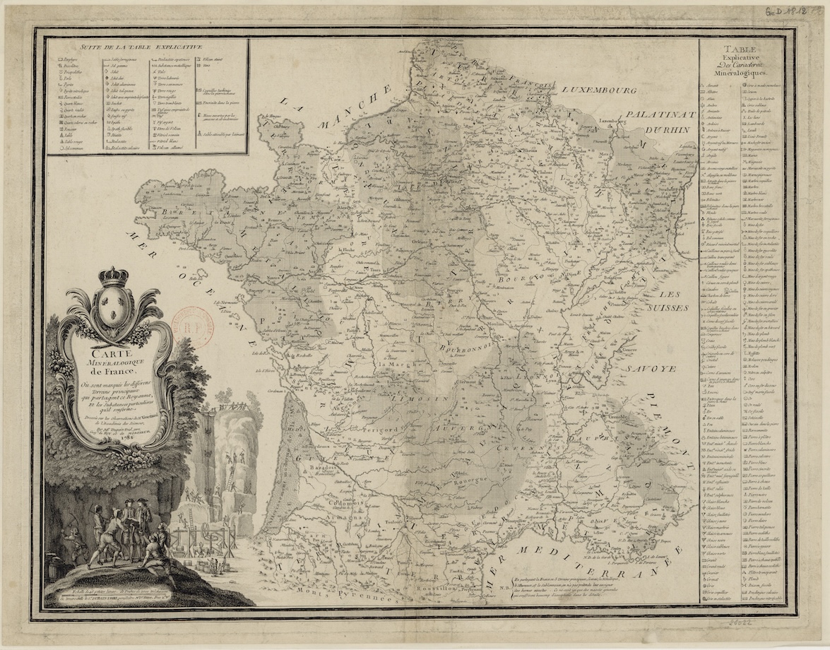
When Jean-Louis Dupain-Triel produced the first comprehensive mineralogical map of France in 1781 (Fig. 1), he was among a small but growing group of cartographers and scientists who were debating how the topographical logic of mapping could best register the profound depths of the subsurface world. In the emerging field of geology, an emphatically vertical way of conceptualizing space was coming into conflict with the lateral format through which existing mapping techniques pictured landscapes. This development was shaped, moreover, by the economic imperatives of resource extraction. Produced in the service of French mining administrators, Dupain-Triel’s map registered a growing tension between lateral and vertical ways of picturing the world in late eighteenth-century France. Through his map, we can glimpse how the growth of industrial resource extraction in France instigated a larger shift in which landscape was increasingly oriented and conceptualized through a vertical rather than a horizontal axis.[3]
The extraction of minerals expanded significantly over the course of the eighteenth century, although French mining lagged meaningfully behind that of Britain, Sweden, and the Germanic states. Metals and coal were becoming major engines of economic growth.[4] Iron, for example, was vital for agricultural tools and building. Coal grew in value as the expansion of energy-intensive industries such as glassworks and ironworks confronted timber shortages across France.[5] Seen as key to the economic and military interests of the nation, mines became both a focal point of state action and a vehicle for the formation of a modern technocratic state.[6] As Isabelle Laboulais has argued, the late eighteenth-century French state used topography as a rubric for ordering knowledge about the nation’s mineral wealth, sponsoring projects to centralize information about “the territorial distribution” of its valuable ores.[7] The first report devoted to cataloguing the nation’s mineral resources, which was produced between 1716 and 1718, reflected the state’s twin desires to inventory its natural wealth and to assess how its resources could be utilized in economic terms.[8] In 1744, the state asserted sovereign ownership of all subsoil property in France and required landowners to obtain formal concessions to operate mines.[9] This stood in contrast to Britain, where landowners retained ownership of the mineral wealth that lay beneath the surface of their property.
Dupain-Triel’s 1781 map consolidated the information gathered in an earlier, ground-breaking atlas of France’s mineral resources for which Dupain-Triel had also produced several plates. The Atlas minéralogique de France was commissioned in 1766 by Henri Bertin, the Minister and Secretary of State in charge of mining. It was conceived and initially overseen by the scientists Antoine Lavoisier and Jean-Etienne Guettard, who planned to author a text accompanied by 214 maps. The maps of the Atlas minéralogique—a half-dozen of which were engraved by Dupain-Triel—diagram the territorial distribution of valuable minerals such as alum, marble, iron, copper, lead, and cobalt, in addition to more quotidian materials like sand and natural wonders like volcanos.
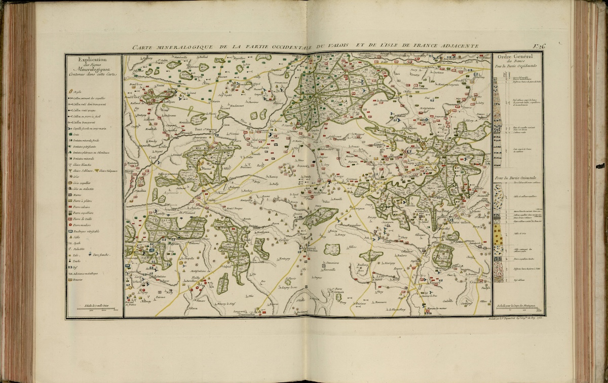
The Atlas was marked, however, by the divergent aims of its creators and the irreconcilable pictorial modes each required.[10] On the left of this Lavoisier and Guettard 1766 plate (Fig. 2), engraved by Dupain-Triel, a key informs the viewer which symbols on the map correspond to each kind of underground mineral deposit. Spread laterally across the print, the symbols denote where a given kind of deposit has been found—a technique called “spot distribution.” The map’s spot distribution was overseen by Guettard and drew upon over a decade of his fieldwork. While it enables the viewer to identify the precise location of a deposit, what this technique omits is information about the deposit’s depth, extent, pattern, and mineral context. On the right margin of the print, two vertical cross-sections show the general subterranean distribution of rock in the region’s eastern and western portions. Based upon the measurements and techniques pioneered by Lavoisier, such cross-sections portrayed either the vertical distribution of rock strata at a specific mine or quarry or a hypothetical view denoting the general layering of strata in a larger region.[11] These two modes of picturing reflected fundamentally different imperatives: Guettard sought to diagram the geographical location of mineral deposits, whereas Lavoisier was interested in showing the physical and historical sequence through which various kinds of rock had formed. Each necessitated a different spatial axis: Guettard’s information was best expressed laterally, whereas Lavoisier’s information could only be conveyed through a vertical cross-section.

Lavoisier’s diagrams belonged to the ascendant study of stratigraphy, an account of the historical formation and vertical layering of different kinds of rock. Stratigraphy, although it did not yet have a name, marked a new direction for geology, which was essentially concerned with the deep history of the earth as recorded through the layering of rock strata.[12] Within early stratigraphic illustrations, time was expressed as a function of depth: the deeper a layer, the older it was thought to be.[13] Already spreading through German geological literature and diagrams in the late eighteenth century, stratigraphy’s dominance in France would not be formalized until the publication of Georges Cuvier and Alexandre Brongniart’s 1811 geological map of the Paris Basin (Fig. 3).[14]
When the still-unfinished Atlas project was taken over in 1777 by a high-ranking civil servant in the Department of Mines named Antoine-Grimoald Monnet, Lavoisier’s measurements were omitted from the remaining maps. The margins of the resulting plates included some cross-sections of specific locations, and they also portrayed landscape profiles and illustrations of rock specimens.[15] Under Monnet, Lavoisier’s scientific interest in the temporal sequence in which rock strata formed was subordinated to the needs of mining administrators to optimize the extraction of the nation’s mineral resources.[16] In the end, only 45 of the projected 214 maps were produced. Monnet authored the accompanying text, which gave some credit to Guettard but made only passing reference to Lavoisier’s decade-long work on the project.
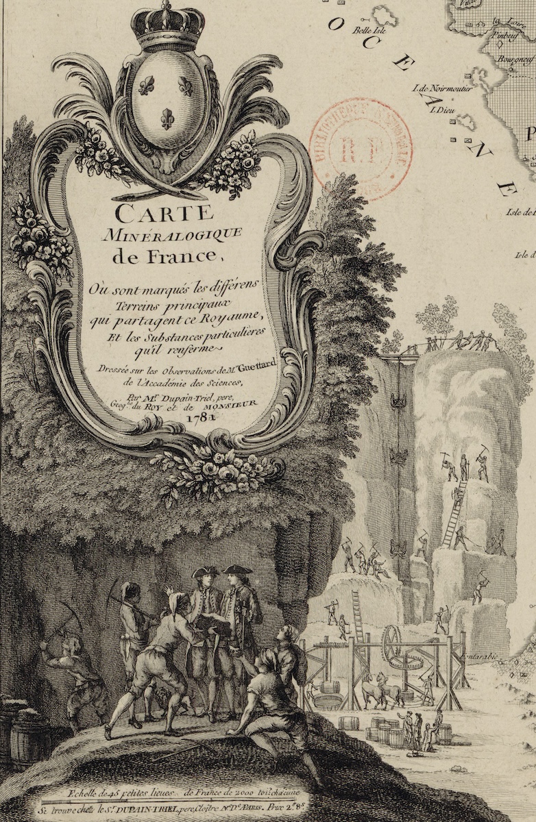
Dupain-Triel’s subsequent 1781 mineralogical map of France consolidated the findings of Guettard and Lavoisier onto a single sheet. Crucially, the omission of any cross-sections signals the map’s allegiance to the practicalities of mining administration over the emerging study of stratigraphy within geology. It also suggests the endurance of a lateral way of picturing and perhaps also conceptualizing the natural world even after initial forays into the vertical orientation of stratigraphic mapping. An allegorical scene at the base of the map’s cartouche (Fig. 4) portrays two mining administrators in conversation, while laborers felicitously present them with extracted ore. More faintly, an illustration of open-pit mining (a technique used for limestone, coal, granite, and marble, among other materials) takes the place of a stratigraphic vertical cross-section of the earth. Shown from deep within the mine, this vertical cross-section is well ordered, with rock shelves placed at regular intervals and a pulley system bringing material up from its depths. Rather than diagram a historical sequence of rock formations, the illustration portrays the frictionless removal of materials from the physical landscape. At the base, two horses power another vertical transit system that was used for transporting water, laborers, and extracted minerals from the depths of a closed mine shaft to the earth’s surface. Here, an even deeper world is alluded to but not pictured: the hidden extension of galleries beneath the visible surface of the landscape. The hypothetical cross-section of the mining pit is contrasted with the emphatically lateral logic of the diegetic space of the map it accompanies.
From this vantage point, Dupain-Triel’s 1781 map emerges as a transition object. Shaped by the needs of France’s fledgling mining industry, it prioritized spot distribution and topography over the vertical orientation required by the ascendant field of stratigraphy. The map’s underlying intellectual affiliations are clarified by the cartouche’s citation of Guettard but not Lavoisier. For the first time, territorial France came into view as a terrain whose latent mineral resources far exceeded its present mining infrastructure. It was a space whose geographical coordinates had already been established but whose subsurface economic value could only now be properly apprehended within a single sheet.
The Carte minéralogique de France retained a lateral framework for organizing and picturing the mineral world. Within a few decades, though, the vertical logic exemplified in Cuvier and Brongniart’s stratigraphic diagram came to dominate the visual culture of mining and geology. The vertical cross-section employed by Lavoisier and popularized by Cuvier and Brongniart gave pictorial form to a broader spatial reorientation taking place in the late eighteenth century: the protocols of European capitalism shifted, Jason Moore argues, from the “horizontal frontiers” of territorial expansion and trade to “vertical frontiers…whose most prominent manifestation was the coal seam.”[17] Produced in the midst of this shift, Dupain-Triel’s 1781 mineralogical map compels us to take more seriously the extent to which mining placed specific and lasting demands upon the picturing of space in eighteenth-century France. And it requires us to see, in turn, how pictorial representations of the physical environment were mobilized in the service of a modernizing French economy predicated on resource extraction.
Stephanie O’Rourke is a Senior Lecturer in art history at the University of St Andrews in Scotland
[1] This stands in contrast to the emerging field of hydrography, which was more explicitly concerned with picturing sub-surface phenomena. See Josef Konvitz, Cartography in France 1669-1848: Science, Engineering, and Statecraft (Chicago: University of Chicago Press, 1987), 63-81.
[2] On the integration of military training and surveying at the turn of the nineteenth century see Mirela Altić, “Building the Great Chain, Expanding the Empire: Triangulation in the Time of Napoleon,” The Cartographic Journal 60 (July 2023). DOI: 10.1080/00087041.2023.2172535.
[3] My approach is indebted to work by historians of geology on verticality, mining, and natural history at the turn of the nineteenth century. See Patrick Anthony, “Mines, Mountains, and the Making of a Vertical Consciousness in Germany ca. 1800,” Centaurus 62 (2020): 612-630; and Bruce Braun, “Producing Vertical Territory: Geology and Governmentality in Late Victorian Canada,” Ecumene 7 no. 1 (2000): 7-46. On diagrammatic verticality see note 13.
[4] Although I focus on the material and economic aspects of mining, recent scholarship has sought to illuminate its social and cultural dynamics. I recommend Hjalmar Fors, The Limits of Matter: Chemistry, Mining, and Enlightenment (Chicago: University of Chicago Press, 2015). On the early modern origins of these developments, see the special issue Tina Asmussen, ed., “Cultural and Material Worlds of Mining in Early Modern Europe,” Renaissance Studies 34, no. 1 (2020): 1-148.
[5] On timber shortages and conflicts over woodland use, see Kieko Matteson, Forests in Revolutionary France: Conservation, Community, and Conflict, 1669-1848 (Cambridge: Cambridge University Press, 2015).
[6] This argument was originally put forward in relation to industrial forest management in James Scott, Seeing like a State: How Certain Schemes to Improve the Human Condition Have Failed (New Haven: Yale University Press, 1998). Although its most acute expression can be found in the Germanic states, Isabelle Laboulais demonstrates its relevance to French mining administration at the turn of the nineteenth century in Laboulais, “Serving Science and the State: Mining Science in France, 1794-1810,” Minerva 46, no. 1 (March 2008): 17-36. The broader context for this was explored in Eric Brian, La Mesure de l’Etat: Administrateurs et géomètres au XVIIIe siècle (Paris: Albin Michel, 1994). On the relationship between mining administration and cameralism in Germany, see E.P. Hamm, “Knowledge from Underground: Leibniz Mines the Enlightenment,” Earth Sciences History 16, no. 2 (1997): 77-99; and Bernd-Stefan Grewe and Richard Hölzl, “Forestry in Germany, c. 1550-2000” in Managing Northern Europe’s Forests: Histories from the Age of Improvement to the Age of Ecology, eds. K. Jan Oosthoek and Richard Hölz (Oxford: Berghahn Books, 2018): 15-65.
[7] Isabelle Laboulais, “Territorialisation and the Logistics of Knowledge and Learning: The Case of Mineral Resource Surveys in France in the Eighteenth Century,” in Transnational Cultures of Expertise: Circulating State-Related Knowledge in the 18th and 19th Centuries, ed. L. Schilling and J. Vogel (Berlin: De Gruyter Oldenbourg, 2019), 150. It also played a significant role in maps of colonial North America, as analyzed in Camille Mathieu, “An Effortless Empire: John Law and the Imagery of French Louisiana, 1683-1735,” Journal18 Issue 10 1720 (Fall 2020), https://www.journal18.org/5285.
[8] An exceptional source of documents on this can be found in Christiane Demeulenaere-Douyere and David J. Sturdy, eds., L’Enquête du Régent, 1716-1718. Sciences, techniques et politique dans la France pré-industrielle (Paris: Brepols, 2008). On the creation of an administrative unit dedicated to mining, see Arthur Birembaut, “L’Enseignement de la Minéralogie et des Techniques Minières,” in Écoles techniques et militaires au XVIIIe siècle, eds. Roger Hahn and René Taton(Paris: Hermann, 1986), 384-5.
[9] Thomas le Roux, “Mines et environnement en France, 1740-1820. Le Filon des concessions,” Annales historiques de la Révolution française 399, no. 1 (2020): 39-67.
[10] Isabelle Laboulais, “Le voyage minéralogique de Guettard et Lavoisier,” in Le voyage à l’époque modern, Actes du Colloque de l’Association des historiens modernistes des universités (Paris: Presses de l’Université de Paris-Sorbonne, 2004), 65-82.
[11] Lavoisier pioneered the use of a barometer for creating the measurements that informed these cross sections. Rhoda Rappaport, “The Early Disputes between Lavoisier and Monnet, 1777-1781,” The British Journal for the History of Science 4, no. 3 (1969): 236-7.
[12] Rhoda Rappaport, When Geologists Were Historians, 1665-1750 (Ithaca: Cornell University Press, 1997).
[13] Nicholaas A. Rupke, “‘The End of History’ in the Early Picturing of Geological Time,” History of Science 36, no. 1 (1998): 61-90. On the relationship between art, deep time, and stratigraphy in the German context, see Stephanie O’Rourke, “Staring into the Abyss of Time,” Representations 148, no. 1 (2019): 30-56.
[14] Early stratigraphic theories gained some prominence in France through the publication of the Comte de Buffon’s Théorie de la terre in 1749. The Encyclopédie’sentry on mining expresses ambivalence about the specifics of the theory but affirms broader claims about the formation of rock strata through successive events. Paul Henri d’Holbach, “Mine,” Encyclopédie, ou dictionnaire raisonné des sciences, des arts et des métiers, etc., eds. Denis Diderot and Jean le Rond d’Alembert. University of Chicago: ARTFL Encyclopédie Project (Autumn 2022 Edition), eds. Robert Morrissey and Glenn Roe: https://encyclopedie.uchicago.edu. Accessed on January 11, 2024.
[15] Rhoda Rappaport, “The Geological Atlas of Guettard, Lavoisier, and Monnet: Conflicting Views of the Nature of Geology,” in Towards a History of Geology, ed. C.J. Schneer (Cambridge: MIT Press, 1969), 272–87.
[16] Rappaport, “The Early Disputes,” 237.
[17] Jason W. Moore, “Ecology, Capital, and the Nature of Our Times: Accumulation and Crisis in the Capitalist World-Ecology,” American Sociological Association 17 no. 1 (2011), 124.
Cite this note as: Stephanie O’Rourke, “Jean-Louis Dupain-Triel’s Carte minéralogique de France (1781),” Journal18 (February 2024), https://www.journal18.org/7196.
License: CC BY-NC
Journal18 is published under a Creative Commons CC BY-NC International 4.0 license. Use of any content published in Journal18 must be for non-commercial purposes and appropriate credit must be given to the author of the content. Details for appropriate citation appear above.